<< Our Photo Pages >> Castro do Zambujal - Castro or Chafurdão in Portugal in Lisboa
Submitted by Bak_teria on Tuesday, 09 September 2014 Page Views: 3175
Iron Age and Later PrehistorySite Name: Castro do Zambujal Alternative Name: Monumento pré-histórico do Casal do ZambujalCountry: Portugal Distrito: Lisboa Type: Castro or Chafurdão
Nearest Town: Torres Vedras Nearest Village: Casal do Zambujal
Latitude: 39.074371N Longitude: 9.285526W
Condition:
| 5 | Perfect |
| 4 | Almost Perfect |
| 3 | Reasonable but with some damage |
| 2 | Ruined but still recognisable as an ancient site |
| 1 | Pretty much destroyed, possibly visible as crop marks |
| 0 | No data. |
| -1 | Completely destroyed |
| 5 | Superb |
| 4 | Good |
| 3 | Ordinary |
| 2 | Not Good |
| 1 | Awful |
| 0 | No data. |
| 5 | Can be driven to, probably with disabled access |
| 4 | Short walk on a footpath |
| 3 | Requiring a bit more of a walk |
| 2 | A long walk |
| 1 | In the middle of nowhere, a nightmare to find |
| 0 | No data. |
| 5 | co-ordinates taken by GPS or official recorded co-ordinates |
| 4 | co-ordinates scaled from a detailed map |
| 3 | co-ordinates scaled from a bad map |
| 2 | co-ordinates of the nearest village |
| 1 | co-ordinates of the nearest town |
| 0 | no data |
Internal Links:
External Links:
I have visited· I would like to visit
Bak_teria visited on 6th Sep 2014 - their rating: Cond: 4 Amb: 4 Access: 5
Ana visited on 6th Sep 2014 - their rating: Cond: 4 Amb: 4 Access: 5
Average ratings for this site from all visit loggers: Condition: 4 Ambience: 4 Access: 5
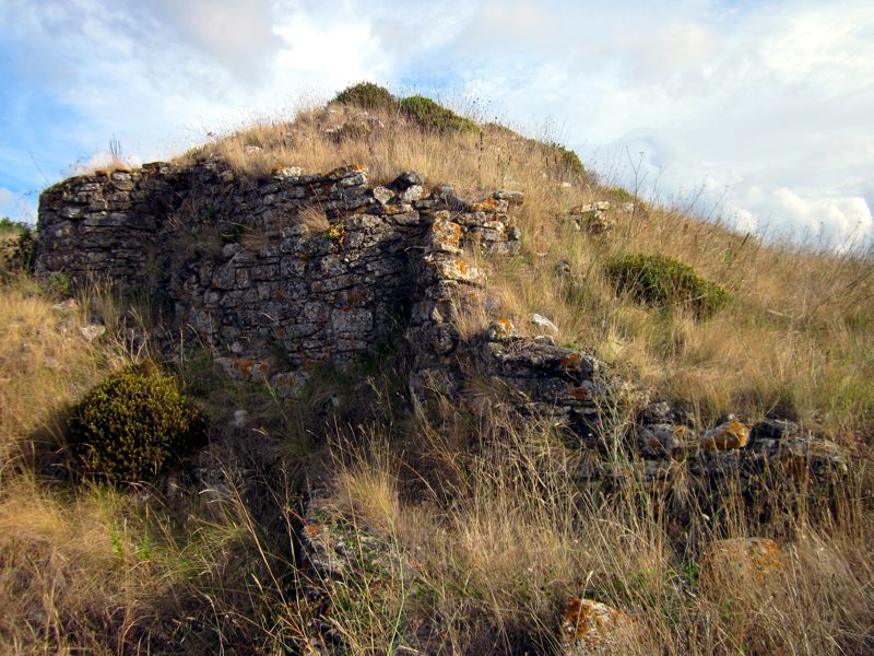
The first systematic excavations took place under the leadership of Leonel Trindade himself during the period from 1959 to 1961. From 1964 and until 1973 the excavations were carried out and organized by the Madrid section of the German Archaeological Institute and were again repeated in 1994/95 . Since 1996 periodic excavations resulted from a partnership between that institute and the Portuguese Institute of Archaeology with the support of the Municipality of Torres Vedras.
The four building phases
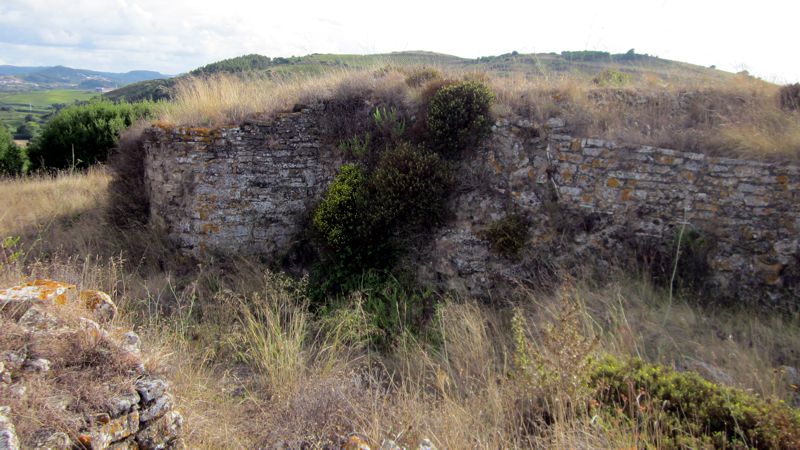
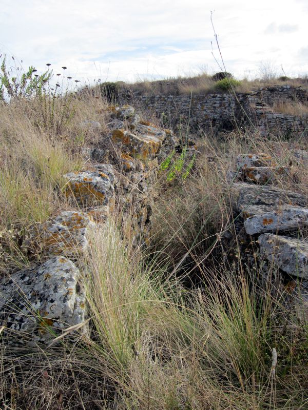
This Castro is one of the most paradigmatic examples of the innovative aspects of the Chalcolithic in Extremadura, the building of fortified villages was a result of the profound socio-economic transformations that occurred during this period. It has an inner enclosure of about 50 metres long reinforced with circular and semicircular bastions with a thickness of 5 to 10 metres. In the beginning this site would be protected only by a central fortress with massive towers and relatively narrow walls. In the second phase of its occupation came the need to strengthen these structures. It was for this reason that there arose two more lines of walls while it was proceeded to build a barbican added to the initial fortress. These new elevations have 'loopholes' but its purpose still remains unknown.
Also identified is a third reinforcing phase of this complex defence system at a time when the functionality and purpose of the "barbican" and the corresponding input line of the second walls were clearly alleviated. There was a tendency to empower the defensive logistics of each of the walls. Finally we are seeing what is considered as the fourth and final phase of the construction of this system, from the rise of hollow towers to the partial destruction of the town which occurred around 1700 BC.
About the location
There is no certainty for the motifs that led to the choice of this site for the construction of this Castro and what were the reasons for their apparent commercial and strategic dominance. However given the available data we can assume by the morphology of the terrain and by the existence at the time of a possible natural harbour at the confluence of the Pedrulhos river and Sizandro river and that it allowed navigable access to the sea.
The emergence of these towns and their historical framework allow us to suppose the existence of a certain degree of social stratification. The central enclosure was designed for the people of higher status and for the protection of products resulting from metallurgical and commercial practice. The majority of the population lived from agriculture and cattle raising and used the surroundings of the village for that purpose.
About the culture
The accumulation of wealth is reflected in found ornaments of precious stones and in an industry that has become the cultural paradigm of the era: the bell shaped ceramic. In this region was found the oldest traces of this production that would extend slightly throughout Europe.
Given the importance and the relevance of the local in European Prehistory it's intended to continue the excavations so it can reveal the full extent of the ancient settlement and then to be built an interpretive centre for the preservation and dissemination for the general public. Local authorities are considering proposing the Castro of Zambujal to UNESCO's ranking of World Heritage Sites.
Links and information sources (all texts written in Portuguese):
- IGESPAR
- Portal do Arqueólogo
- Deutsches Archäologisches Institut
You may be viewing yesterday's version of this page. To see the most up to date information please register for a free account.



Do not use the above information on other web sites or publications without permission of the contributor.
Click here to see more info for this site
Nearby sites
Click here to view sites on an interactive map of the areaKey: Red: member's photo, Blue: 3rd party photo, Yellow: other image, Green: no photo - please go there and take one, Grey: site destroyed
Download sites to:
KML (Google Earth)
GPX (GPS waypoints)
CSV (Garmin/Navman)
CSV (Excel)
To unlock full downloads you need to sign up as a Contributory Member. Otherwise downloads are limited to 50 sites.
Turn off the page maps and other distractions
Nearby sites listing. In the following links * = Image available
2.1km ESE 111° Tholos do Barro* Chambered Tomb
16.2km SSE 156° Tholos da Tituaria* Chambered Tomb
18.8km N 353° Museu da Lourinhã* Museum
21.8km SSE 164° Anta de Carcavelos* Burial Chamber or Dolmen
21.8km SSW 200° Conjunto Megalítico de Barreira* Standing Stones
23.2km SSE 162° Gruta de Salemas* Cave or Rock Shelter
23.4km SSE 162° Anta do Alto da Toupeira* Burial Chamber or Dolmen
23.8km SSE 155° Anta de Casaínhos* Burial Chamber or Dolmen
23.9km NE 55° Castro de Pragança* Castro or Chafurdão
26.5km SE 139° Dólmen de Monte Serves* Burial Chamber or Dolmen
30.3km S 169° Anta das Pedras Grandes* Burial Chamber or Dolmen
31.6km SSW 195° Sintra Menhir* Standing Stone (Menhir)
32.6km SSW 196° Castelo dos Mouros, Sintra* Cave or Rock Shelter
32.9km NNW 342° Gruta da Furninha* Cave or Rock Shelter
33.5km S 180° Anta da Agualva* Burial Chamber or Dolmen
33.5km S 177° Anta do Senhor da Serra* Burial Chamber or Dolmen
33.7km S 174° Necrópole de Carenque* Rock Cut Tomb
33.9km S 177° Anta da Estria* Burial Chamber or Dolmen
34.1km S 177° Anta do Monte Abraão* Burial Chamber or Dolmen
34.5km NNE 21° Cidade Romana de Eburobritium Ancient Village or Settlement
36.0km SSW 202° Tholos do Monge* Chambered Tomb
36.4km SSW 205° Anta de Adrenunes* Burial Chamber or Dolmen
37.1km S 180° Fábrica da Pólvora de Barcarena* Museum
37.8km SSE 154° Humming Stone Lisbon (Summstein) Modern Stone Circle etc
38.5km S 180° Castro de Leceia* Castro or Chafurdão
View more nearby sites and additional images




 We would like to know more about this location. Please feel free to add a brief description and any relevant information in your own language.
 Wir möchten mehr über diese Stätte erfahren. Bitte zögern Sie nicht, eine kurze Beschreibung und relevante Informationen in Deutsch hinzuzufügen.
 Nous aimerions en savoir encore un peu sur les lieux. S'il vous plaît n'hesitez pas à ajouter une courte description et tous les renseignements pertinents dans votre propre langue.
 Quisieramos informarnos un poco más de las lugares. No dude en añadir una breve descripción y otros datos relevantes en su propio idioma.