

<< Our Photo Pages >> Bamble Offerlund - Timber Circle in Norway in Telemark
Submitted by kenntha88 on Thursday, 27 September 2012 Page Views: 1918
Neolithic and Bronze AgeSite Name: Bamble OfferlundCountry: Norway Fylke: Telemark Type: Timber Circle
Nearest Town: Porsgrunn Nearest Village: Bamble
Latitude: 59.009740N Longitude: 9.667861E
Condition:
| 5 | Perfect |
| 4 | Almost Perfect |
| 3 | Reasonable but with some damage |
| 2 | Ruined but still recognisable as an ancient site |
| 1 | Pretty much destroyed, possibly visible as crop marks |
| 0 | No data. |
| -1 | Completely destroyed |
| 5 | Superb |
| 4 | Good |
| 3 | Ordinary |
| 2 | Not Good |
| 1 | Awful |
| 0 | No data. |
| 5 | Can be driven to, probably with disabled access |
| 4 | Short walk on a footpath |
| 3 | Requiring a bit more of a walk |
| 2 | A long walk |
| 1 | In the middle of nowhere, a nightmare to find |
| 0 | No data. |
| 5 | co-ordinates taken by GPS or official recorded co-ordinates |
| 4 | co-ordinates scaled from a detailed map |
| 3 | co-ordinates scaled from a bad map |
| 2 | co-ordinates of the nearest village |
| 1 | co-ordinates of the nearest town |
| 0 | no data |
Internal Links:
External Links:
")
This is perhaps one of the most interesting and unusual ancient sites of my visit this summer! It is not barrows, stones or carvings, but actually trees from what is said to have been a "holy grove" from the iron age. I didnt know exactly what type of site i could put this in, but I choosed the closest I could think of, though it is not a exactly a timber circle.
According to historical sources, the use of holy groves have probably been widely used in the iron age.
The German chronicler Adam of Bremen has described how it was done at the Temple at Uppsala at Old Uppsala in Sweden, ca 1070:
"Every ninth year there is a blót of nine days, a common feast for everyone in Sweden. Then they sacrifice nine males of each species, even men, and the bodies are hung from the branches of a grove near the temple. No one is exempt from this blót and everyone sends gifts to the shrine, even the kings. Those who are Christian have to pay a fee not to take part in the blót."
This particular site however is close to the old Bamble church. It is an old church ruin from the 1200s. In many places there are examples of modern churches and cemeteries been placed near old pagan ritualistic sites. Probably to "clean" the place from old traditions.
The site today consists of two huge and very old oak trees that is said to have been here since pagan times. It is also said it has once been a "hov" or a construction for ancient rites on this spot, and the trees originally comes from the holy grove.
Another thing that fascinates me is that the local people have continued some of the old traditions up to this day! At midwinter it is custom to pour beer at the base of the trees! It is probably remains from the ancient pagan culture.
You may be viewing yesterday's version of this page. To see the most up to date information please register for a free account.
")
")
")
Do not use the above information on other web sites or publications without permission of the contributor.
Nearby Images from Flickr
The above images may not be of the site on this page, but were taken nearby. They are loaded from Flickr so please click on them for image credits.
Click here to see more info for this site
Nearby sites
Click here to view sites on an interactive map of the areaKey: Red: member's photo, Blue: 3rd party photo, Yellow: other image, Green: no photo - please go there and take one, Grey: site destroyed
Download sites to:
KML (Google Earth)
GPX (GPS waypoints)
CSV (Garmin/Navman)
CSV (Excel)
To unlock full downloads you need to sign up as a Contributory Member. Otherwise downloads are limited to 50 sites.
Turn off the page maps and other distractions
Nearby sites listing. In the following links * = Image available
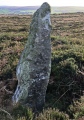
313m WSW 236° Bamble standing stone* Standing Stone (Menhir)
901m SW 232° Steinsjordene sacrificial marsh* Natural Stone / Erratic / Other Natural Feature
2.7km NNE 12° Rugtvedt Settlement* Ancient Village or Settlement
8.2km NNE 22° Lerstang* Stone Circle
8.3km NNE 22° Rødvik-Slottet* Hillfort
9.8km ESE 114° Mølen* Cairn
11.7km NE 42° Landgangen* Rock Art
12.2km N 9° Eidanger Prestegård* Barrow Cemetery
14.5km E 90° Sannisteinen* Standing Stone (Menhir)
15.3km E 85° Kongerødhaugen Barrow* Round Barrow(s)
15.4km ESE 104° Hummerbakken-Høgvik* Ancient Village or Settlement
15.6km NNE 15° Bjørkedalen-Flogstad* Barrow Cemetery
15.7km N 351° Østre Klyve* Barrow Cemetery
16.4km E 87° Hvatum Standing Stone* Standing Stone (Menhir)
16.6km E 87° Bratthaugåsen* Barrow Cemetery
17.2km N 356° Borgestad* Stone Circle
17.3km E 84° Presteåsen* Standing Stone (Menhir)
17.6km N 350° Lyngbakken* Barrow Cemetery
17.8km NE 40° Omsland* Barrow Cemetery
18.0km NNW 341° Findal Nordre* Barrow Cemetery
18.6km NNW 338° Holtan* Barrow Cemetery
19.9km NNW 345° Gimsø Kloster* Barrow Cemetery
20.1km E 90° Brunla cemetery* Barrow Cemetery
21.0km E 88° Agnes stones* Stone Circle
21.1km ENE 75° Bøkeskogen* Barrow Cemetery
View more nearby sites and additional images


 We would like to know more about this location. Please feel free to add a brief description and any relevant information in your own language.
 Wir möchten mehr über diese Stätte erfahren. Bitte zögern Sie nicht, eine kurze Beschreibung und relevante Informationen in Deutsch hinzuzufügen.
 Nous aimerions en savoir encore un peu sur les lieux. S'il vous plaît n'hesitez pas à ajouter une courte description et tous les renseignements pertinents dans votre propre langue.
 Quisieramos informarnos un poco más de las lugares. No dude en añadir una breve descripción y otros datos relevantes en su propio idioma.