

<< Our Photo Pages >> Knock Stone Circle - Modern Stone Circle etc in Scotland in West Lothian
Submitted by h_fenton on Saturday, 12 March 2011 Page Views: 16915
Modern SitesSite Name: Knock Stone CircleCountry: Scotland County: West Lothian Type: Modern Stone Circle etc
Nearest Town: Bathgate
Map Ref: NS99137133
Latitude: 55.924431N Longitude: 3.615799W
Condition:
| 5 | Perfect |
| 4 | Almost Perfect |
| 3 | Reasonable but with some damage |
| 2 | Ruined but still recognisable as an ancient site |
| 1 | Pretty much destroyed, possibly visible as crop marks |
| 0 | No data. |
| -1 | Completely destroyed |
| 5 | Superb |
| 4 | Good |
| 3 | Ordinary |
| 2 | Not Good |
| 1 | Awful |
| 0 | No data. |
| 5 | Can be driven to, probably with disabled access |
| 4 | Short walk on a footpath |
| 3 | Requiring a bit more of a walk |
| 2 | A long walk |
| 1 | In the middle of nowhere, a nightmare to find |
| 0 | No data. |
| 5 | co-ordinates taken by GPS or official recorded co-ordinates |
| 4 | co-ordinates scaled from a detailed map |
| 3 | co-ordinates scaled from a bad map |
| 2 | co-ordinates of the nearest village |
| 1 | co-ordinates of the nearest town |
| 0 | no data |
Internal Links:
External Links:
I have visited· I would like to visit
AstroGeologist visited on 25th Aug 2018 - their rating: Cond: 4 Amb: 4 Access: 3 Knock Stone Circle :
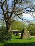
The Knock Stone Circle has 50 stones, with 17 of them in the smaller circle (although an 18th one may have been moved and now laying in the centre next to the Dolmen)
Inside the inner circle is a mini Dolmen raised up off the grass by 3 tiny stones, and a small Menhir to the West of the Dolmen.
Outside the circle, around 60m to the NE, standing on a small ridge is a waist height Menhir, it has an unusual shape to it, reminding me of a Cetacea of some sort.
The Mystery Stones ;
No one knows exactly when these stones got put up, there are several stories doing the rounds regarding them. The stones look old, but we are told they only got put up less than 25 years ago.
*Some sources say it was built in 1998 by the farmers son at Knock Farm as a surprise for his dads 50th - would his dad not have noticed this massive circle being built?
*Others have told me it was actually built in memory of his father when he passed away - it may be difficult to find out when he passed away.
*And lastly, the comment below suggests it wasn't built in 2006 when an artist was painting the area - why was he painting an empty, featureless field l wonder? could this painter be mistaken?
Is it possible some of these stones were there already and the farmers son rebuilt them? Or perhaps the NE Menhir was always there, No one really knows, and the farmers son has never been interviewed.
Whatever the case may be, the Stone Circle looks spectacular, especially on a Sunny day. I like the small Dolmen in the centre, it is a nice touch.
Definitely worth a look when on your way to Cairnpapple Henge & Cairn, which is visible from the Stone Circle.
*Getting There ; About an hour walk from Bathgate train station, which is 3.9km away.
Coming from the Gala Braes Menhir, continue North on along the country road for 1.6km. There are no turns to take, just a slight bend in the road, getting here is pretty straightforward.
Anne T visited on 18th May 2017 - their rating: Cond: 4 Amb: 4 Access: 5 Knock Modern Stone Circle, West Lothian: Having passed this stone circle on the way to Cairnpapple, it looked impressive and I couldn’t wait to get back for a closer look. “Is this what a real stone circle looks like?” my friend (who is a relatively novice Megalith-hunter) asked. I chuckled as I read out the description from the Portal page which I’d printed off before I left home
It certainly looks as if it’s been here longer than 20 years!
The field was full of enormous sheep. The farmer has kindly built a small stile into the fence by the gate, which allowed us access into the field. We wandered round taking photographs. I really liked the little stone ‘seat’ in the inner ring, which the sheep gathered round.
I walked over to the outlier, which sits on a mound to the north-east of the circle.
On our way out, a car pulled out, parking half an inch from the bumper of our car. Out popped a photographer with a really big lens on his camera. He wandered up and down the road by the fence, taking photographs. We told him he could get into the field, either through the gate or over the stile. He said ‘thanks, but I’m waiting to get photos without the sheep’. As there were around 50 or so sheep in the field, I’m guessing he might have had some time to wait.
We headed off to Torphinchen for a snack and to visit the Preceptory (which was closed, even though the sign said it should have been open).
ModernExplorers visited on 4th Mar 2013 - their rating: Cond: 5 Amb: 2 Access: 5 Looks good, I'm curious why the farmer decided to build it
h_fenton Andy B have visited here
Average ratings for this site from all visit loggers: Condition: 4.33 Ambience: 3.33 Access: 4.33
")
Two concentric circles of standing stones (comprising 50 massive stones in all, with one horizontal stone supported on three vertical ones at the centre of the circles)
Note: If you visit Cairnpapple Hill, don't miss this modern wonder down the road
You may be viewing yesterday's version of this page. To see the most up to date information please register for a free account.
")
")
")
")
")
")
")
")
")
")
")
")
")
")
")
")
")
")
")
")
")
")
")
Do not use the above information on other web sites or publications without permission of the contributor.
Click here to see more info for this site
Nearby sites
Key: Red: member's photo, Blue: 3rd party photo, Yellow: other image, Green: no photo - please go there and take one, Grey: site destroyed
Download sites to:
KML (Google Earth)
GPX (GPS waypoints)
CSV (Garmin/Navman)
CSV (Excel)
To unlock full downloads you need to sign up as a Contributory Member. Otherwise downloads are limited to 50 sites.
Turn off the page maps and other distractions
Nearby sites listing. In the following links * = Image available
586m NW 314° Cairnpapple Hill* Round Cairn (NS98727175)
1.0km NNW 329° Lower Craigmailing (Torphichen)* Ancient Cross (NS98627222)
1.4km N 357° Craigmailing Boundary Marker (Torphichen)* Marker Stone (NS99097270)
1.5km S 190° Galabraes* Standing Stone (Menhir) (NS9881869839)
2.1km NNW 328° Gormyre* Standing Stone (Menhir) (NS98067311)
2.5km N 358° Kipps Farm* Round Cairn (NS99087387)
2.6km WNW 296° Torphichen Churchyard Stone* Standing Stone (Menhir) (NS96847250)
3.1km N 355° Cockleroy Hill (Beecraigs)* Hillfort (NS98947438)
3.5km W 260° North Couston Refuge Stone* Early Christian Sculptured Stone (NS95637078)
3.6km NE 47° Beecraigs Round Cairn (NT01827372)
4.1km N 357° Williamcraigs Standing Stone* Natural Stone / Erratic / Other Natural Feature (NS99037544)
4.8km W 278° Westfield Farm Refuge Stone* Early Christian Sculptured Stone (NS94377211)
5.7km N 355° The Boarstane (Linlithgow) Standing Stone (Menhir) (NS98757706)
5.9km N 9° Cross Well (Linlithgow)* Holy Well or Sacred Spring (NT0021677170)
6.8km WSW 256° Hillhouse (Torphichen) Standing Stone (Menhir) (NS92456984)
7.5km WSW 244° Boar Stone (Armadale)* Natural Stone / Erratic / Other Natural Feature (NS92336820)
10.9km NE 54° Justice Stone Standing Stone (Menhir) (NT08087759)
11.7km SSE 154° Cromwell's Stone (West Calder) Natural Stone / Erratic / Other Natural Feature (NT03986068)
11.9km NE 48° Abercorn Sculptured Stone (NT08147910)
13.0km NW 309° Marion's Well (Falkirk) Holy Well or Sacred Spring (NS89267977)
13.0km ESE 108° Kirknewton stone Sculptured Stone (NT11426693)
13.2km E 83° Huly Hill Standing Stones* Standing Stones (NT1234272610)
13.2km E 83° Huly Hill Cairn* Round Cairn (NT1234272610)
13.6km E 83° Lochend menhir* Standing Stone (Menhir) (NT12667263)
13.7km E 95° Witches' Stone (Ratho)* Rock Art (NT12736973)
View more nearby sites and additional images


 We would like to know more about this location. Please feel free to add a brief description and any relevant information in your own language.
 Wir möchten mehr über diese Stätte erfahren. Bitte zögern Sie nicht, eine kurze Beschreibung und relevante Informationen in Deutsch hinzuzufügen.
 Nous aimerions en savoir encore un peu sur les lieux. S'il vous plaît n'hesitez pas à ajouter une courte description et tous les renseignements pertinents dans votre propre langue.
 Quisieramos informarnos un poco más de las lugares. No dude en añadir una breve descripción y otros datos relevantes en su propio idioma.