<< Our Photo Pages >> Wycoller Iron Age Bridge (Standing Stone) - Standing Stone (Menhir) in England in Lancashire
Submitted by Sunny100 on Sunday, 01 August 2010 Page Views: 15742
Iron Age and Later PrehistorySite Name: Wycoller Iron Age Bridge (Standing Stone) Alternative Name: The Clam Bridge, Wycoller Slab BridgeCountry: England County: Lancashire Type: Standing Stone (Menhir)
Nearest Town: Colne Nearest Village: Wycoller
Map Ref: SD93583889
Latitude: 53.846210N Longitude: 2.099062W
Condition:
| 5 | Perfect |
| 4 | Almost Perfect |
| 3 | Reasonable but with some damage |
| 2 | Ruined but still recognisable as an ancient site |
| 1 | Pretty much destroyed, possibly visible as crop marks |
| 0 | No data. |
| -1 | Completely destroyed |
| 5 | Superb |
| 4 | Good |
| 3 | Ordinary |
| 2 | Not Good |
| 1 | Awful |
| 0 | No data. |
| 5 | Can be driven to, probably with disabled access |
| 4 | Short walk on a footpath |
| 3 | Requiring a bit more of a walk |
| 2 | A long walk |
| 1 | In the middle of nowhere, a nightmare to find |
| 0 | No data. |
| 5 | co-ordinates taken by GPS or official recorded co-ordinates |
| 4 | co-ordinates scaled from a detailed map |
| 3 | co-ordinates scaled from a bad map |
| 2 | co-ordinates of the nearest village |
| 1 | co-ordinates of the nearest town |
| 0 | no data |
Internal Links:
External Links:
I have visited· I would like to visit
FrothNinja has visited here
 (PID:62018)")
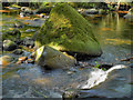
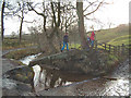
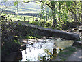
This one is a bit of an oddity, I know. But, according to local historians and others, this long slab-stone that spans Wycoller Beck is a former standing stone (menhir).
Apparently it dates from the Iron Age and used to stand somewhere on the moors to the NE of the little, secluded village. The warden of the Wycoller Country Park assures me that this is correct.
It was apparently brought down to the beck (or rolled along on logs) in a similar way, perhaps, to the great sarsons at Stonehenge. It was then placed across the beck to afford access. It is made of gritstone and roughly measures 12 foot long. In fact, it is one single length of stone, now flattened and worn by time. In the floods of 1989 and 1990 it was brought crashing down and broken in two places. However, the slab was restored again; you can see where the breaks occured due to the iron clasps on the underside. There was once a rail attached to the slab - now only its holes remain.
On the moors overlooking Wycoller there was a Bronze Age burial mound and also an Iron Age settlement. Over the years objects of antiquity have been found including arrow heads, flint scrapers, a large anvil-shaped stone and also a flint knapping stone.
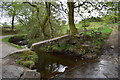
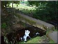
Back down the footpath to Wycoller's ruined hall there is the Clapper Bridge - two long stone slabs supported by a central stone pier. It is deeply worn in the middle by two centuries of weavers' feet. This bridge is also called Druids Bridge - the thinking being than it led to a sort of amphitheatre where druidical sacrifices were carried out. However, this is just the stuff of myth and legend and without any real truth. The clapper bridge is probably medieval.
For more information see Pastscape Monument No. 46147 which does not give a date for the millstone grit bridge, but says it is of historical important, there are plans to rebuild it.
The Journal of Antiquities also features an entry for the The Three Ancient Bridges, Wycoller, Lancashire; scroll down their webpage for information about this bridge, along with photographs and a list of reference sources for more information. Whilst in the area, the JoA also includes information about two other bridges nearby: the Old Packhorse Bridge or Sally's Bridge at SD 932383 39247 and the Druid's Bridge (also known as Weaver's Bridge or Hall Bridge) which is near the ruins of Wycoller Hall (see The History of Wycoller for more details).
You may be viewing yesterday's version of this page. To see the most up to date information please register for a free account.
 (PID:62021)")
 (PID:62011)")
 (PID:62023)")
 (PID:62013)")
Do not use the above information on other web sites or publications without permission of the contributor.
Nearby Images from Geograph Britain and Ireland:
©2011(licence)
©2019(licence)
©2014(licence)
©2005(licence)
©2007(licence)
The above images may not be of the site on this page, they are loaded from Geograph.
Please Submit an Image of this site or go out and take one for us!
Click here to see more info for this site
Nearby sites
Key: Red: member's photo, Blue: 3rd party photo, Yellow: other image, Green: no photo - please go there and take one, Grey: site destroyed
Download sites to:
KML (Google Earth)
GPX (GPS waypoints)
CSV (Garmin/Navman)
CSV (Excel)
To unlock full downloads you need to sign up as a Contributory Member. Otherwise downloads are limited to 50 sites.
Turn off the page maps and other distractions
Nearby sites listing. In the following links * = Image available
630m NW 310° Wycoller Cup-marked Stones* Rock Art (SD931393)
673m NE 45° Herder's Cross (Wycoller) Ancient Cross (SD9405639367)
685m NW 323° Lowlands Well (Wycoller) Holy Well or Sacred Spring (SD93173944)
951m NNE 26° Ratten Clough Cross (Emmot Moor) Ancient Cross (SD9399739746)
1.1km SSE 156° Brink Ends Cairn Cairn (SD94033786)
1.8km NE 40° Emmott Moor Rock Art (SD9475040285)
1.8km NNW 348° Hullown Well* Holy Well or Sacred Spring (SD93204067)
2.0km E 98° Coombe Hill (Wycoller) Ancient Cross (SD9558638608)
2.7km S 171° Boulsworth Hill Carvings* Carving (SD9397836237)
3.0km NW 323° Cold Well (Laneshawbridge)* Holy Well or Sacred Spring (SD91804125)
3.3km E 98° Great Moss (Emmott Moor) Standing Stone (Menhir) (SD969384)
3.6km E 100° Watersheddles Cross* Standing Stone (Menhir) (SD9712338276)
3.8km ENE 61° Ickornshaw Moor* Rock Art (SD9689040731)
3.9km ESE 119° Lad of Crow Hill* Not Known (by us) (SD970370)
4.1km S 183° Dove Stones (Widdop Moor)* Natural Stone / Erratic / Other Natural Feature (SD93333479)
4.2km E 90° Old Bess Stone (Oakworth Moor) Standing Stone (Menhir) (SD978389)
4.4km WSW 244° Knave Hill (Nelson)* Cairn (SD8963636991)
4.4km WSW 251° Walton Spire Stone* Standing Stone (Menhir) (SD8939137498)
4.4km WSW 249° Walton Spire Cross* Standing Stone (Menhir) (SD8941637328)
4.6km W 280° St. Helen's Well (Waterside, Colne)* Holy Well or Sacred Spring (SD890397)
4.7km ESE 107° Silver Hill* Round Barrow(s) (SD981375)
4.7km WSW 245° Ring Stones Hill Stone Circle (SD89263693)
4.9km SE 130° Alcomden Stones* Rock Outcrop (SD9731335737)
4.9km WNW 284° Emmott Cross (Colne) Ancient Cross (SD888401)
4.9km SW 222° Broadbank* Ancient Village or Settlement (SD9023935227)
View more nearby sites and additional images


 We would like to know more about this location. Please feel free to add a brief description and any relevant information in your own language.
 Wir möchten mehr über diese Stätte erfahren. Bitte zögern Sie nicht, eine kurze Beschreibung und relevante Informationen in Deutsch hinzuzufügen.
 Nous aimerions en savoir encore un peu sur les lieux. S'il vous plaît n'hesitez pas à ajouter une courte description et tous les renseignements pertinents dans votre propre langue.
 Quisieramos informarnos un poco más de las lugares. No dude en añadir una breve descripción y otros datos relevantes en su propio idioma.