 with our Megalithic Portal iPhone app")

<< Our Photo Pages >> Heysham Rock-Cut tombs - Rock Cut Tomb in England in Lancashire
Submitted by Sunny100 on Friday, 14 June 2019 Page Views: 32990
Multi-periodSite Name: Heysham Rock-Cut tombs Alternative Name: Heysham Stone Graves, St Patrick's Rock TombsCountry: England County: Lancashire Type: Rock Cut Tomb
Nearest Town: Morecambe Nearest Village: Heysham
Map Ref: SD4098461655
Latitude: 54.047466N Longitude: 2.902829W
Condition:
| 5 | Perfect |
| 4 | Almost Perfect |
| 3 | Reasonable but with some damage |
| 2 | Ruined but still recognisable as an ancient site |
| 1 | Pretty much destroyed, possibly visible as crop marks |
| 0 | No data. |
| -1 | Completely destroyed |
| 5 | Superb |
| 4 | Good |
| 3 | Ordinary |
| 2 | Not Good |
| 1 | Awful |
| 0 | No data. |
| 5 | Can be driven to, probably with disabled access |
| 4 | Short walk on a footpath |
| 3 | Requiring a bit more of a walk |
| 2 | A long walk |
| 1 | In the middle of nowhere, a nightmare to find |
| 0 | No data. |
| 5 | co-ordinates taken by GPS or official recorded co-ordinates |
| 4 | co-ordinates scaled from a detailed map |
| 3 | co-ordinates scaled from a bad map |
| 2 | co-ordinates of the nearest village |
| 1 | co-ordinates of the nearest town |
| 0 | no data |
Internal Links:
External Links:
I have visited· I would like to visit
TysonM AmyBlahBlahBlah would like to visit
bishop_pam visited on 17th Nov 2022 - their rating: Cond: 5 Amb: 5 Access: 4
cactus_chris visited on 8th Aug 2020 - their rating: Cond: 5 Amb: 5 Access: 4
coin visited - their rating: Cond: 4 Amb: 4 Access: 4
WhiskyRiver visited - their rating: Cond: 5 Amb: 5 Access: 4
rldixon have visited here
Average ratings for this site from all visit loggers: Condition: 4.75 Ambience: 4.75 Access: 4
")
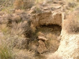
A set of six of these, two straight-sided and four body-shaped all with socket holes at the top where a wooden cross would have been placed. Two more rock-cut graves can be seen close by. The graves are often filled with rain water.
In 1970 a cemetary to the S of this site was excavated and 85 sets of bones were found and dated to the 10th-11th century. The rock cut graves are grade 1 listed and a Scheduled Ancient Monument.
Also of interest here is the ruined St Patrick's Chapel, possibly dating back to 750 AD or a little later. The rectangular-shaped chapel measures roughly 27 feet by 9 feet. One of the best bits is the curved Anglo-Saxon doorway. The stonework consists of large lumps of rough-hewn sandstone with thiner stonework sections between and at the top. St Patrick may well have visited this place in the 5th century, though the chapel is much later - although it could have been built to commemorate his landing here. Certainly this is quite a fascinating early Christian site.
This site is scheduled as Historic England List ID 1020535 (St Patrick's early Christian chapel and associated cemetery, Lower Heysham), with a number of associated records:
Rock cut tombs 10m west of chapel: List ID 1292902;
Chapel of St Patrick: List ID 1208949; and
Rock Cut Tombs 4m SE of chapel: List ID 1207215.
The Journal of Antiquities also includes an entry for the hogback - see their page for St Patrick’s Chapel And Rock Graves, Heysham, Lancashire, which includes photographs, directions for finding this site, a description, and a list of reference sources for more information.
You may be viewing yesterday's version of this page. To see the most up to date information please register for a free account.
")
")
")
")
")
")
")
")
")
")
")
")
")
")
")
")
")
")
")
")
")
")
")
")
These are just the first 25 photos of Heysham Rock-Cut tombs. If you log in with a free user account you will be able to see our entire collection.
Do not use the above information on other web sites or publications without permission of the contributor.
Click here to see more info for this site
Nearby sites
Key: Red: member's photo, Blue: 3rd party photo, Yellow: other image, Green: no photo - please go there and take one, Grey: site destroyed
Download sites to:
KML (Google Earth)
GPX (GPS waypoints)
CSV (Garmin/Navman)
CSV (Excel)
To unlock full downloads you need to sign up as a Contributory Member. Otherwise downloads are limited to 50 sites.
Turn off the page maps and other distractions
Nearby sites listing. In the following links * = Image available
88m ESE 120° Heysham St Peter's Churchyard* Ancient Cross (SD41066161)
123m ESE 121° St Patrick's Well (Heysham)* Holy Well or Sacred Spring (SD4108961591)
288m WSW 258° Heysham Labyrinth* Carving (SD407616)
973m SE 140° Church Well (Heysham) Holy Well or Sacred Spring (SD416609)
4.3km NE 40° Fartle Barrow* Cairn (SD4380364966)
5.6km ENE 62° Torrisholme* Round Barrow(s) (SD45966425)
6.4km E 87° Lancaster Priory Cross* Ancient Cross (SD474619)
6.6km E 89° Lancaster City Museum* Museum (SD4761161729)
7.7km E 93° Golgotha Lodge (Williamson Park) Cairn (SD48666121)
9.4km ENE 70° Halton St Wilfrid's Churchyard* Ancient Cross (SD49916469)
9.5km NE 50° Bolton Le Sands Early Christian Sculptured Stone (SD48336765)
9.5km NE 49° St Michael's Well (Lancashire) Holy Well or Sacred Spring (SD4828567831)
9.9km ENE 70° The Lancaster Cross* Ancient Cross (SD504649)
10.0km NE 53° Bolton-le-Sands Barrow* Ring Cairn (SD4901467624)
11.7km E 86° Askew Heights* Ancient Village or Settlement (SD52726239)
11.9km N 350° Fairy Stone (Humphrey Head)* Natural Stone / Erratic / Other Natural Feature (SD39157344)
12.0km NE 41° Hunting Hill* Round Barrow(s) (SD49037065)
12.4km N 350° Holy Well (Humphrey Head)* Holy Well or Sacred Spring (SD39017391)
12.5km NE 34° Cote Stones Cairn (SD482719)
13.3km NNE 31° Ings Point Natural Stone / Erratic / Other Natural Feature (SD479730)
13.3km NNE 32° Badger Hole (Lancashire)* Cave or Rock Shelter (SD48187285)
13.3km NNE 21° Woodwell* Holy Well or Sacred Spring (SD4674)
13.5km NNE 32° Dog Holes* Cave or Rock Shelter (SD48337303)
13.7km NE 36° Warton Crag* Hillfort (SD492727)
14.3km N 352° Kirkhead Cave Cave or Rock Shelter (SD391758)
View more nearby sites and additional images


 We would like to know more about this location. Please feel free to add a brief description and any relevant information in your own language.
 Wir möchten mehr über diese Stätte erfahren. Bitte zögern Sie nicht, eine kurze Beschreibung und relevante Informationen in Deutsch hinzuzufügen.
 Nous aimerions en savoir encore un peu sur les lieux. S'il vous plaît n'hesitez pas à ajouter une courte description et tous les renseignements pertinents dans votre propre langue.
 Quisieramos informarnos un poco más de las lugares. No dude en añadir una breve descripción y otros datos relevantes en su propio idioma.