<< Other Photo Pages >> Bow Castle Broch - Broch or Nuraghe in Scotland in Scottish Borders
Submitted by Andy B on Sunday, 18 April 2010 Page Views: 9106
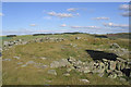
Iron Age and Later PrehistorySite Name: Bow Castle BrochCountry: Scotland County: Scottish Borders Type: Broch or Nuraghe
Nearest Town: Galashiels Nearest Village: Torsonce
Map Ref: NT4613541717
Latitude: 55.665960N Longitude: 2.857845W
Condition:
| 5 | Perfect |
| 4 | Almost Perfect |
| 3 | Reasonable but with some damage |
| 2 | Ruined but still recognisable as an ancient site |
| 1 | Pretty much destroyed, possibly visible as crop marks |
| 0 | No data. |
| -1 | Completely destroyed |
| 5 | Superb |
| 4 | Good |
| 3 | Ordinary |
| 2 | Not Good |
| 1 | Awful |
| 0 | No data. |
| 5 | Can be driven to, probably with disabled access |
| 4 | Short walk on a footpath |
| 3 | Requiring a bit more of a walk |
| 2 | A long walk |
| 1 | In the middle of nowhere, a nightmare to find |
| 0 | No data. |
| 5 | co-ordinates taken by GPS or official recorded co-ordinates |
| 4 | co-ordinates scaled from a detailed map |
| 3 | co-ordinates scaled from a bad map |
| 2 | co-ordinates of the nearest village |
| 1 | co-ordinates of the nearest town |
| 0 | no data |
Internal Links:
External Links:
I have visited· I would like to visit
Andy B has visited here
")
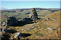
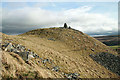
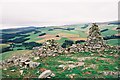
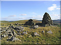
This is one of only three brochs in the Scottish Borders, the other two being at Torwoodlee near Galashiels and Edin's Hall near Abbey St Bathans.
For further information see Canmore ID 54520 which says: "This broch stands on level ground on the brink of a steep descent SW to the valley of the Gala Water. The ruin of its wall is surmounted by a tall modern cairn built out of the debris. The broch was originally formed by a wall 15ft thick, enclosing an area 31ft in diameter, with the entrance in the NE. It was excavated in 1890 when pottery, including some 2nd century Roman amphora fragments, were found, and in 1922 a 2nd century Roman enamelled bronze brooch in the form of a cock was found among the ruins of the wall. This, and other small finds, are in the NMAS. ( R W Feachem 1963) ..... The rubble remains of this broch occupy the summit of a hill. Its wall, 4.5m thick and 0.5m maximum height, encloses a 10.0m diameter court, with an entrance in the E. It has a small modern cairn on its W side. On the gentle slope E of the broch are the slight remains of walls and the occasional scooped area."
You may be viewing yesterday's version of this page. To see the most up to date information please register for a free account.
")
Do not use the above information on other web sites or publications without permission of the contributor.
Nearby Images from Geograph Britain and Ireland:
©2011(licence)
©2008(licence)
©2010(licence)
©2006(licence)
©2006(licence)
The above images may not be of the site on this page, they are loaded from Geograph.
Please Submit an Image of this site or go out and take one for us!
Click here to see more info for this site
Nearby sites
Key: Red: member's photo, Blue: 3rd party photo, Yellow: other image, Green: no photo - please go there and take one, Grey: site destroyed
Download sites to:
KML (Google Earth)
GPX (GPS waypoints)
CSV (Garmin/Navman)
CSV (Excel)
To unlock full downloads you need to sign up as a Contributory Member. Otherwise downloads are limited to 50 sites.
Turn off the page maps and other distractions
Nearby sites listing. In the following links * = Image available
2.2km NNW 343° Our Lady's Well (Borders)* Holy Well or Sacred Spring (NT45524386)
3.3km S 172° Torwoodlee* Broch or Nuraghe (NT46553847)
4.0km ESE 110° Hawksnest (Langshaw) Ring Cairn (NT499403)
5.3km N 9° Cathpair Standing Stone (Menhir) (NT47004700)
6.6km SSW 199° Caddonlee* Hillfort (NT43963551)
9.2km SSE 168° Rink Hill (Boleside) Hillfort (NT48023270)
12.3km N 3° Kirktonhill Stone Circle (NT470540)
12.8km NE 41° Dabshead Hill* Standing Stone (Menhir) (NT54715124)
12.8km ENE 58° Thirlestane Hill Hillfort (NT57054845)
12.9km SE 133° Eildon Hill North* Hillfort (NT55453280)
12.9km ENE 68° Dods Corse Stone (Boon)* Ancient Cross (NT58214633)
13.1km ESE 123° Trimontium* Ancient Village or Settlement (NT57033435)
13.2km SE 127° Rhymer's Stone (Melrose)* Marker Stone (NT5651833592)
13.2km SW 231° Cheese Well* Holy Well or Sacred Spring (NT35693357)
13.4km NNE 27° Addinston Hill fort* Hillfort (NT523536)
13.6km E 98° Purveshaugh* Standing Stone (Menhir) (NT59663973)
13.8km S 174° Mungo's Well (Selkirk)* Holy Well or Sacred Spring (NT47342795)
13.8km S 172° Caulks Well (Selkirk)* Holy Well or Sacred Spring (NT4789127983)
13.9km ENE 61° Cambridge Standing Stone* Standing Stone (Menhir) (NT58434826)
14.2km NE 42° Borrowstone Rig Round Cairn (NT55775223)
14.3km NE 41° Borrowstone Rig* Stone Circle (NT55765231)
14.3km NE 41° Borrowston Rigg* Stone Circle (NT5576052315)
14.3km ENE 57° Blythe Fort Hillfort (NT58244941)
15.1km S 188° Tamlane's Well (Carterhaugh)* Holy Well or Sacred Spring (NT43742681)
15.8km ENE 59° Bruntaburn Mill* Standing Stone (Menhir) (NT59814979)
View more nearby sites and additional images


 We would like to know more about this location. Please feel free to add a brief description and any relevant information in your own language.
 Wir möchten mehr über diese Stätte erfahren. Bitte zögern Sie nicht, eine kurze Beschreibung und relevante Informationen in Deutsch hinzuzufügen.
 Nous aimerions en savoir encore un peu sur les lieux. S'il vous plaît n'hesitez pas à ajouter une courte description et tous les renseignements pertinents dans votre propre langue.
 Quisieramos informarnos un poco más de las lugares. No dude en añadir una breve descripción y otros datos relevantes en su propio idioma.