<< Our Photo Pages >> Poulawack Cairn - Cairn in Ireland (Republic of) in Co. Clare
Submitted by jeffrep on Thursday, 21 August 2008 Page Views: 7177
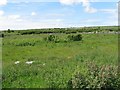
Neolithic and Bronze AgeSite Name: Poulawack CairnCountry: Ireland (Republic of) County: Co. Clare Type: Cairn
Nearest Town: Ennis Nearest Village: Poulawack
Map Ref: R2323998520
Latitude: 53.032152N Longitude: 9.14491W
Condition:
| 5 | Perfect |
| 4 | Almost Perfect |
| 3 | Reasonable but with some damage |
| 2 | Ruined but still recognisable as an ancient site |
| 1 | Pretty much destroyed, possibly visible as crop marks |
| 0 | No data. |
| -1 | Completely destroyed |
| 5 | Superb |
| 4 | Good |
| 3 | Ordinary |
| 2 | Not Good |
| 1 | Awful |
| 0 | No data. |
| 5 | Can be driven to, probably with disabled access |
| 4 | Short walk on a footpath |
| 3 | Requiring a bit more of a walk |
| 2 | A long walk |
| 1 | In the middle of nowhere, a nightmare to find |
| 0 | No data. |
| 5 | co-ordinates taken by GPS or official recorded co-ordinates |
| 4 | co-ordinates scaled from a detailed map |
| 3 | co-ordinates scaled from a bad map |
| 2 | co-ordinates of the nearest village |
| 1 | co-ordinates of the nearest town |
| 0 | no data |
Internal Links:
External Links:
I have visited· I would like to visit
jeffrep visited on 17th Apr 2008 - their rating: Cond: 3 Amb: 3 Access: 3
")
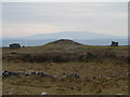
Poulawack Cairn has been dated variously by several observers to be between 3000 and 1900 BCE. Excavation in 1935 revealed the remains of 16 people buried in 10 separate graves. Since so few people were buried here over such a long period indicates that this cairn was a burial place for high-ranking individuals. One observation claims that very few bodies were cremated at this site, indicating Bronze Age origin, a period when unburnt burials were quite common. Nearby, and frankly more visually if not archaeologically interesting, is an extremely elaborate souterrain (see photos).
You may be viewing yesterday's version of this page. To see the most up to date information please register for a free account.
Do not use the above information on other web sites or publications without permission of the contributor.
Nearby Images from Geograph Britain and Ireland:
©2006(licence)
©2008(licence)
©2009(licence)
©2018(licence)
©2008(licence)
The above images may not be of the site on this page, they are loaded from Geograph.
Please Submit an Image of this site or go out and take one for us!
Click here to see more info for this site
Nearby sites
Click here to view sites on an interactive map of the areaKey: Red: member's photo, Blue: 3rd party photo, Yellow: other image, Green: no photo - please go there and take one, Grey: site destroyed
Download sites to:
KML (Google Earth)
GPX (GPS waypoints)
CSV (Garmin/Navman)
CSV (Excel)
To unlock full downloads you need to sign up as a Contributory Member. Otherwise downloads are limited to 50 sites.
Turn off the page maps and other distractions
Nearby sites listing. In the following links * = Image available
265m NE 52° Poulawack Rath and Souterrain* Souterrain (Fogou, Earth House)
1.0km NNE 19° Caherconnell* Stone Fort or Dun (R236995)
1.5km S 188° Iskancullin* Wedge Tomb (R230970)
1.9km N 10° Poulnabrone* Portal Tomb (M2359500356)
2.1km NW 314° Baur South Cairn* Cairn
2.2km NNW 334° Baur North* Wedge Tomb (M223005)
2.2km NW 315° Baur South* Wedge Tomb (M217001)
2.2km WNW 287° Lissylisheen* Wedge Tomb (R211992)
2.6km E 83° Meggagh* Wedge Tomb (R258988)
3.0km NW 324° Poulnabrucky* Wedge Tomb (M215010)
3.2km NNE 32° Ballymihil* Wedge Tomb (M250012)
3.7km N 355° Gleninsheen 1* Wedge Tomb (M230022)
3.8km N 357° Gleninsheen 2* Wedge Tomb (M231023)
3.9km WNW 293° Cahermacnaughten Stone Fort or Dun (M197001)
4.5km NE 44° Poulaphuca* Wedge Tomb (M264017)
5.0km ESE 122° Creevagh* Wedge Tomb (R274958)
5.0km SW 218° Ballykinvarga* Stone Fort or Dun (R201946)
5.1km NNE 28° Boloona* Wedge Tomb (M257030)
5.3km ESE 111° Cahercommaun* Hillfort (R282965)
5.7km SSE 150° Parknabinnia Court Tomb* Court Tomb (R2602193585)
5.7km SSE 153° Parknabinnia 1* Wedge Tomb (R25749341)
5.8km ESE 108° Tullycommon* Wedge Tomb (R287966)
5.8km E 96° Castletown Wedge Tomb* Wedge Tomb (R290978)
5.8km SE 140° Commons North 2* Wedge Tomb (R269940)
5.8km SE 140° Commons North 1* Wedge Tomb (R269940)
View more nearby sites and additional images


 We would like to know more about this location. Please feel free to add a brief description and any relevant information in your own language.
 Wir möchten mehr über diese Stätte erfahren. Bitte zögern Sie nicht, eine kurze Beschreibung und relevante Informationen in Deutsch hinzuzufügen.
 Nous aimerions en savoir encore un peu sur les lieux. S'il vous plaît n'hesitez pas à ajouter une courte description et tous les renseignements pertinents dans votre propre langue.
 Quisieramos informarnos un poco más de las lugares. No dude en añadir una breve descripción y otros datos relevantes en su propio idioma.