 with our Megalithic Portal iPhone app")

<< Our Photo Pages >> Rotensande Langbett 4 - Long Barrow in Germany in Schleswig-Holstein, Hamburg
Submitted by holger_rix on Monday, 24 September 2007 Page Views: 3156
Neolithic and Bronze AgeSite Name: Rotensande Langbett 4 Alternative Name: Sprockhoff 64, Riesenbetten RothensandeCountry: Germany Land: Schleswig-Holstein, Hamburg Type: Long Barrow
Nearest Town: Eckernfoerde Nearest Village: Waabs
Latitude: 54.534772N Longitude: 9.951083E
Condition:
| 5 | Perfect |
| 4 | Almost Perfect |
| 3 | Reasonable but with some damage |
| 2 | Ruined but still recognisable as an ancient site |
| 1 | Pretty much destroyed, possibly visible as crop marks |
| 0 | No data. |
| -1 | Completely destroyed |
| 5 | Superb |
| 4 | Good |
| 3 | Ordinary |
| 2 | Not Good |
| 1 | Awful |
| 0 | No data. |
| 5 | Can be driven to, probably with disabled access |
| 4 | Short walk on a footpath |
| 3 | Requiring a bit more of a walk |
| 2 | A long walk |
| 1 | In the middle of nowhere, a nightmare to find |
| 0 | No data. |
| 5 | co-ordinates taken by GPS or official recorded co-ordinates |
| 4 | co-ordinates scaled from a detailed map |
| 3 | co-ordinates scaled from a bad map |
| 2 | co-ordinates of the nearest village |
| 1 | co-ordinates of the nearest town |
| 0 | no data |
Internal Links:
External Links:
")
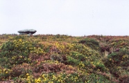
The four Long Barrows of Rotensande.
Located on a very beautiful spot on the Schwansen peninsula.
Three barrows close together, one more a little distant.
This is Long Barrow 4
You may be viewing yesterday's version of this page. To see the most up to date information please register for a free account.
")
")
")
")
")
")
")
")
")
Do not use the above information on other web sites or publications without permission of the contributor.
Click here to see more info for this site
Nearby sites
Click here to view sites on an interactive map of the areaKey: Red: member's photo, Blue: 3rd party photo, Yellow: other image, Green: no photo - please go there and take one, Grey: site destroyed
Download sites to:
KML (Google Earth)
GPX (GPS waypoints)
CSV (Garmin/Navman)
CSV (Excel)
To unlock full downloads you need to sign up as a Contributory Member. Otherwise downloads are limited to 50 sites.
Turn off the page maps and other distractions
Nearby sites listing. In the following links * = Image available
260m SE 144° Rotensande Langbett 1* Long Barrow
381m SSE 147° Rotensande Langbett 2* Long Barrow
386m SSE 159° Rotensande Langbett 3* Long Barrow
980m E 94° Klein Waabs Huenenbett 1 Long Barrow
1.1km E 91° Klein Waabs Huenenbett 2 Long Barrow
1.1km SE 145° Sophienhof Dolmen* Burial Chamber or Dolmen
1.7km WNW 298° Holzdorf Dolmen* Burial Chamber or Dolmen
2.3km SSE 156° Lehmberg Langbett* Long Barrow
2.6km SE 129° Langholz Steingrab* Burial Chamber or Dolmen
3.5km W 269° Loose Dolmen* Burial Chamber or Dolmen
3.7km SSW 209° Karlsminde Langbett* Long Barrow
5.7km SW 226° Hemmelmark Steingrab (1)* Long Barrow
5.7km SW 226° Hemmelmark Steingrab (2)* Burial Chamber or Dolmen
5.9km SW 227° Hemmelmark Steingrab (5)* Burial Chamber or Dolmen
6.0km SW 227° Hemmelmark Steingrab (4)* Burial Chamber or Dolmen
6.0km SW 226° Hemmelmark Steingrab (6)* Burial Chamber or Dolmen
6.2km NNE 28° Damp Huenenbett Long Barrow
6.2km SW 228° Hemmelmark Steingrab (7)* Burial Chamber or Dolmen
6.6km NNE 28° Damp Steinkreis [Rote Maas]* Stone Circle
6.6km SW 228° Hemmelmark Steingrab (8)* Burial Chamber or Dolmen
6.8km SW 230° Hemmelmark Steingrab (11)* Long Barrow
6.8km SW 230° Hemmelmark Steingrab (9b)* Burial Chamber or Dolmen
6.9km SW 230° Hemmelmark Steingrab (10)* Long Barrow
6.9km SW 230° Hemmelmark Steingrab (14)* Chambered Tomb
6.9km SW 230° Hemmelmark Steingrab (9)* Long Barrow
View more nearby sites and additional images


 We would like to know more about this location. Please feel free to add a brief description and any relevant information in your own language.
 Wir möchten mehr über diese Stätte erfahren. Bitte zögern Sie nicht, eine kurze Beschreibung und relevante Informationen in Deutsch hinzuzufügen.
 Nous aimerions en savoir encore un peu sur les lieux. S'il vous plaît n'hesitez pas à ajouter une courte description et tous les renseignements pertinents dans votre propre langue.
 Quisieramos informarnos un poco más de las lugares. No dude en añadir una breve descripción y otros datos relevantes en su propio idioma.