

<< Our Photo Pages >> Cromeleque da Portela de Mogos - Stone Circle in Portugal in Évora
Submitted by Bak_teria on Saturday, 14 March 2020 Page Views: 16270
Neolithic and Bronze AgeSite Name: Cromeleque da Portela de Mogos Alternative Name: Cromeleque da Portela de ModosCountry: Portugal Distrito: Évora Type: Stone Circle
Nearest Town: Évora
Latitude: 38.626405N Longitude: 8.025635W
Condition:
| 5 | Perfect |
| 4 | Almost Perfect |
| 3 | Reasonable but with some damage |
| 2 | Ruined but still recognisable as an ancient site |
| 1 | Pretty much destroyed, possibly visible as crop marks |
| 0 | No data. |
| -1 | Completely destroyed |
| 5 | Superb |
| 4 | Good |
| 3 | Ordinary |
| 2 | Not Good |
| 1 | Awful |
| 0 | No data. |
| 5 | Can be driven to, probably with disabled access |
| 4 | Short walk on a footpath |
| 3 | Requiring a bit more of a walk |
| 2 | A long walk |
| 1 | In the middle of nowhere, a nightmare to find |
| 0 | No data. |
| 5 | co-ordinates taken by GPS or official recorded co-ordinates |
| 4 | co-ordinates scaled from a detailed map |
| 3 | co-ordinates scaled from a bad map |
| 2 | co-ordinates of the nearest village |
| 1 | co-ordinates of the nearest town |
| 0 | no data |
Internal Links:
External Links:
I have visited· I would like to visit
markhewins would like to visit
TheCaptain visited on 13th Oct 2019 - their rating: Cond: 4 Amb: 5 Access: 4 I have time to look for one or two more sites, the Cromeleque da Portela de Mogos is not far off, and I now remember spending quite some time looking how to find this before the trip. Back to the road from Cromeleque de Vale Maria do Meio, and half a kilometre to the west it goes up over a wooded hill, and I find a place to park beside the road in a layby. The cromlech should be just away from the road on the south side up the hill. Indeed, there is a footpath which can be seen going off into the woodland from a sort of gap in the fence, which can be opened.
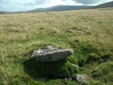
A hundred yards or so up into the woods and a large standing stone can be seen, and then the other stones can also be seen, forming a circular shape around the large one with arms going down the slope. Again it is very like Almendres and Vale Maria do Meio, in that it seems to make an open horseshoe facing down the slope towards the east, although with a circle at the top. There are about 40 stones, and again many are beautifully shaped and have motifs carved onto them.
I am alone here in this lovely wooded place, and think that this is perhaps my favourite place of all my visits, so just linger for a fair while before leaving. After this, it feels wrong to search out any other lesser places, so decide to head back to Evora via the Alto de São Bento viewpoint and the aquaduct.
rrmoser visited on 8th Jun 2018 - their rating: Cond: 4 Amb: 5 Access: 4 The path to the site is not marked on the road but you will see a small pullover and a pallet used as a gate through which you can access the site. Enter and head left or uphill to find the site in the cork forest. This is a tremendous site with great ambiance.
Catrinm visited on 14th Sep 2017 - their rating: Cond: 3 Amb: 5 Access: 4 Very accessible and beautiful site in the woods. We could have done with some directions, so here goes... you need to stop in a lay by on the left coming from Evora, cross road to rhs and look for a kind of gap in barbed wire fence with red and white sign. Climb over wire fence follow path into woods about 100m max.Site is impressive with one very large stone and about 30 others. Some campers have treated it inconsiderately with toilet paper etc.
Bak_teria visited on 4th Apr 2015 - their rating: Cond: 4 Amb: 4 Access: 4
Average ratings for this site from all visit loggers: Condition: 3.75 Ambience: 4.75 Access: 4
")
It is possible that there had been a third circle, now very deteriorated. It was used and reused at the Neolithic, Chalcolithic and Neo-Bronze Age. The lowest menhir has only 5m in diameter and the largest 12.5 m. Three of the monoliths have dimples in the tops, having been recognized two embossed representations of staffs. It's a monument classified as IIP – Imóvel de Interesse Público (Property of Public Interest).
About the architecture and chronology
Within the enclosure can be detected a line formed by five monoliths which marks the north-south axis; one of them is central and has larger dimensions. On the eastern side, there are six menhirs forming an alignment. The menhirs, carved from granodiorite and, in general roughly shaped, present a varied morphology, some having been decorated with motifs, engraved or in relief, namely circles, wavy lines, cup-marks and crozier shapes. Others were leveled during the Late Neolithic period, fixed in a stellar form, and decorated with anthropomorphized compositions in relief, where a face and a half-moon collar can be discerned.
The architecture of this monument as much as the typology and decoration of the menihrs, and also the artifacts exhumed, indicate that it was built and used during the Middle and Late Neolithic periods (5th and 4th millennia BC). However, it would have been used, still with purposes of magico-religious nature, in the middle of the 2nd millennium, as the number of carenated vessels found there testifies, perhaps following a period of abandonment, or of very sporadic use, during the Chalcolithic. In the excavations were also found some articles: a polished stone axe with sub-rectangular section, an exhausted edge and an adze.
About the location
Near by is possible to visit another megalithic gem, the Vale Maria do Meio cromlech. These two megalithic enclosures that are only distant from each other just over a kilometer, have plans and similar arrangements to the Almendres cromlech, although with more modest dimensions.
About the access
It's important to mention you are entering in private property but also that the access is open. There is only one place in the fence of the property and that is the only possible way to get to this site. The following coordinates are very important, memorize them: 38.626543 -8.027737. Without this location you will be lost in the wilderness for hours as I have been. In this particular case it was the geocaching location that saved me.
Most of the information was taken from Mário Varela Gomes, from the blog A Lente Verde.
Webpages where the official classification and asset of this monument is referenced (all texts written in Portuguese):
- IGESPAR
- Portal do Arqueólogo
Links and information sources (texts written in Portuguese and English)
- Portuguese Wikipedia page
- A Lente Verde Blog
Aditional information:
- You are entering in private property but the access from the road is open.
- The entrance to the zone of the monuments may be blocked by fences, they were essentially made to demarcate the land and not allow the escape of livestock. Usually there are spaces in the fences within these demarcated areas where the access is possible. When entering in demarcated land never forget to close the access gate of the location, you need to be very aware because cattle can escape.
- There are no signs prohibiting us from entering so the access can be open but be careful when you explore every time you see this red plaques that alert you for the Hunting Zones. Remind yourself that usually hunters can only hunt at selected hunting days (Thursdays, Sundays and on public holidays).
You may be viewing yesterday's version of this page. To see the most up to date information please register for a free account.
")
")
")
")
")
")
")
")
")
")
")
")
")
")
")
")
")
")
")
")
")
")
")
")
These are just the first 25 photos of Cromeleque da Portela de Mogos. If you log in with a free user account you will be able to see our entire collection.
Do not use the above information on other web sites or publications without permission of the contributor.
Click here to see more info for this site
Nearby sites
Click here to view sites on an interactive map of the areaKey: Red: member's photo, Blue: 3rd party photo, Yellow: other image, Green: no photo - please go there and take one, Grey: site destroyed
Download sites to:
KML (Google Earth)
GPX (GPS waypoints)
CSV (Garmin/Navman)
CSV (Excel)
To unlock full downloads you need to sign up as a Contributory Member. Otherwise downloads are limited to 50 sites.
Turn off the page maps and other distractions
Nearby sites listing. In the following links * = Image available
1.6km ESE 106° Cromeleque de Vale Maria do Meio* Stone Circle
2.1km SW 222° Anta Da Moita Do Gato* Burial Chamber or Dolmen
2.3km ENE 60° Anta Da Valeira 2* Burial Chamber or Dolmen
2.3km ENE 58° Anta Da Valeira 1* Burial Chamber or Dolmen
2.9km E 82° Menir 4 da Herdade do Casbarro* Standing Stone (Menhir)
3.3km E 95° Menires da Herdade da Casbarra* Standing Stones
3.5km WSW 239° Anta Do Patalim 2* Burial Chamber or Dolmen
3.8km W 268° Anta Da Alcava De Cima 2 Burial Chamber or Dolmen
3.8km W 269° Anta Da Alcava De Cima 1 Burial Chamber or Dolmen
4.1km NNW 340° Anta I da Herdade do Silval Burial Chamber or Dolmen
4.1km W 263° Anta Da Malhada Do Outeiro Burial Chamber or Dolmen
4.2km NNW 344° Anta de Paredes Burial Chamber or Dolmen
4.2km NNW 341° Anta II da Herdade do Silval Burial Chamber or Dolmen
4.8km NE 52° Antas do Chainha* Burial Chamber or Dolmen
5.2km NNW 337° Anta Da Cegonheira 1 Burial Chamber or Dolmen
5.2km WSW 240° Anta Das Valadas De Baixo Burial Chamber or Dolmen
5.3km NNW 337° Anta Da Cegonheira 2 Burial Chamber or Dolmen
5.5km NW 321° Anta Da Azinheira Galega Burial Chamber or Dolmen
5.5km NNW 340° Anta Da Cegonheira 3 Burial Chamber or Dolmen
5.8km WSW 244° Pinheiro Do Campo 1* Burial Chamber or Dolmen
5.9km SW 236° Anta do Pinheiro 2* Burial Chamber or Dolmen
6.0km NNW 336° Anta Da Serranheira 2 Burial Chamber or Dolmen
6.1km NW 318° Anta Do Carrascal Burial Chamber or Dolmen
6.5km S 181° Centro Interpretativo dos Almendres* Museum
6.6km NNW 332° Anta Da Serranheira 1 Burial Chamber or Dolmen
View more nearby sites and additional images


 We would like to know more about this location. Please feel free to add a brief description and any relevant information in your own language.
 Wir möchten mehr über diese Stätte erfahren. Bitte zögern Sie nicht, eine kurze Beschreibung und relevante Informationen in Deutsch hinzuzufügen.
 Nous aimerions en savoir encore un peu sur les lieux. S'il vous plaît n'hesitez pas à ajouter une courte description et tous les renseignements pertinents dans votre propre langue.
 Quisieramos informarnos un poco más de las lugares. No dude en añadir una breve descripción y otros datos relevantes en su propio idioma.