Featured: Explore Scotland (and everywhere else) with our Megalithic Portal iPhone app

Explore Scotland (and everywhere else) with our Megalithic Portal iPhone app

Circles of Stone - Max Milligan

Circles of Stone - Max Milligan

Who's Online

There are currently, 304 guests and 1 members online.

You are a guest. To join in, please register for free by clicking here

Sponsors

<< Our Photo Pages >> Wied Filep A - Burial Chamber or Dolmen in Malta in Mainland

Submitted by enkidu41 on Wednesday, 20 October 2004  Page Views: 7647

Neolithic and Bronze AgeSite Name: Wied Filep A
Country: Malta Island: Mainland Type: Burial Chamber or Dolmen
Nearest Town: Valletta  Nearest Village: Mosta
Latitude: 35.919590N  Longitude: 14.431563E
Condition:
5Perfect
4Almost Perfect
3Reasonable but with some damage
2Ruined but still recognisable as an ancient site
1Pretty much destroyed, possibly visible as crop marks
0No data.
-1Completely destroyed
3 Ambience:
5Superb
4Good
3Ordinary
2Not Good
1Awful
0No data.
3 Access:
5Can be driven to, probably with disabled access
4Short walk on a footpath
3Requiring a bit more of a walk
2A long walk
1In the middle of nowhere, a nightmare to find
0No data.
5 Accuracy:
5co-ordinates taken by GPS or official recorded co-ordinates
4co-ordinates scaled from a detailed map
3co-ordinates scaled from a bad map
2co-ordinates of the nearest village
1co-ordinates of the nearest town
0no data
4

Internal Links:
External Links:

I have visited· I would like to visit

SolarMegalith visited on 23rd Mar 2013 - their rating: Cond: 4 Amb: 3 Access: 5
Wied Filep A
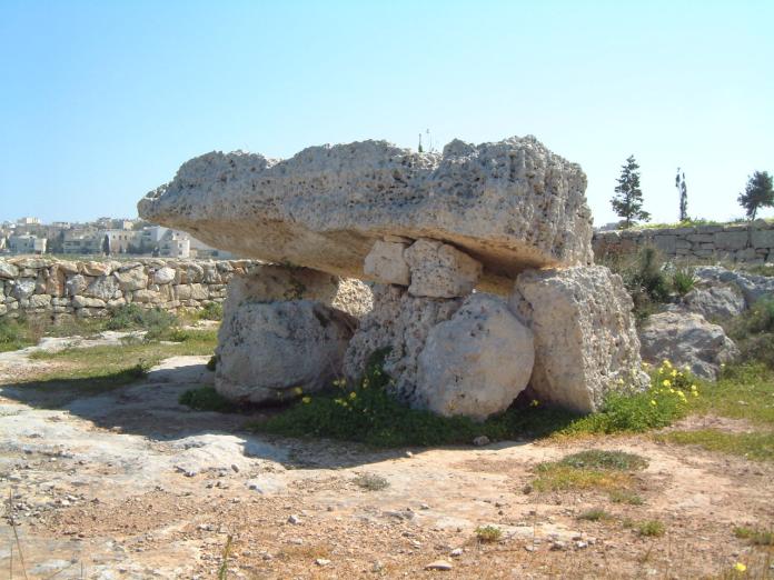
Wied Filep A submitted by enkidu41 : The larger of 2 dolmens standing about 10' apart near Mosta. The massive capstone is 12'6" long by 5'3" wide and stands nearly 5' high. (Vote or comment on this photo)
Burial Chamber (Dolmen) in Malta. By the road from Mosta to Gharghur there are 2 dolmens in a walled enclosure. This is the larger and better preserved of the two.

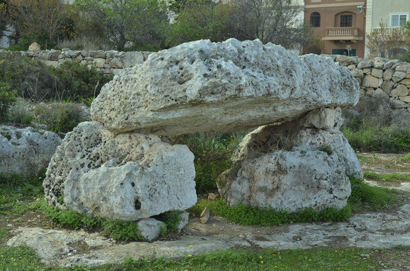
It has a capstone measuring 3.6 metres by 1.7 metres and 60 cms thick. It is supported on either end by stones about 1.4 metres high.
You may be viewing yesterday's version of this page. To see the most up to date information please register for a free account.

Wied Filep A
Wied Filep A submitted by SolarMegalith : Dolmen A in Wied Filep with its 3m long capstone - view from the NE (photo taken on March 2013). (Vote or comment on this photo)

Wied Filep A
Wied Filep A submitted by SolarMegalith : Wied Filep A to the right, Wied Filep B to the left (photo taken on March 2013). (Vote or comment on this photo)

Wied Filep A
Wied Filep A submitted by SolarMegalith : Wied Filep A, the larger of two Bronze Age dolmens - view from the south (photo taken on March 2013). (Vote or comment on this photo)

Wied Filep A
Wied Filep A submitted by ShamrockStone : Wied Filep A (Vote or comment on this photo)

Wied Filep A
Wied Filep A submitted by enkidu41 : The larger of 2 dolmens standing about 10' apart near Mosta. The massive capstone is 12'6" long by 5'3" wide and stands nearly 5' high.

Wied Filep A
Wied Filep A submitted by enkidu41

Do not use the above information on other web sites or publications without permission of the contributor.
Click here to see more info for this site

Nearby sites

Click here to view sites on an interactive map of the area

Key: Red: member's photo, Blue: 3rd party photo, Yellow: other image, Green: no photo - please go there and take one, Grey: site destroyed

Download sites to:
KML (Google Earth)
GPX (GPS waypoints)
CSV (Garmin/Navman)
CSV (Excel)

To unlock full downloads you need to sign up as a Contributory Member. Otherwise downloads are limited to 50 sites.


Turn off the page maps and other distractions

Nearby sites listing. In the following links * = Image available
 1m E 90° Wied Filep B* Burial Chamber or Dolmen
 488m SSE 159° Tal-Wej Cart Ruts* Ancient Trackway
 843m NE 53° Triq il-Fortizza tal-Mosta Cart Ruts* Ancient Trackway
 982m NE 41° San Pawl tat-Targa Cart Ruts* Ancient Trackway
 1.6km W 262° Tarġa Gap Cart Ruts* Ancient Trackway
 2.2km NNW 333° Tal-Qadi* Ancient Temple
 2.4km NW 311° San Pawl Milqi Ancient Palace
 2.8km NNE 29° Ta' Hammut C* Burial Chamber or Dolmen
 2.8km NNE 30° Ta' Hammut D* Burial Chamber or Dolmen
 2.8km NNE 29° Ta' Hammut B* Burial Chamber or Dolmen
 2.9km NNE 30° Ta' Hammut A* Burial Chamber or Dolmen
 3.1km NNE 27° Ta' Hammut cart ruts* Ancient Trackway
 4.1km NNW 343° Buggiba* Ancient Temple
 4.3km ESE 102° Tal-Mensija Cart Tracks San Gwann* Ancient Trackway
 4.7km NW 312° San Pawl il-Baħar Cart ruts* Ancient Trackway
 4.8km W 272° Skorba Settlement* Ancient Village or Settlement
 4.9km W 272° Skorba* Ancient Temple
 4.9km SE 139° Ta' Raddiena* Ancient Temple
 5.0km SW 225° Ghajn Qajjied Cart Ruts* Ancient Trackway
 5.1km WSW 250° Binġemma Valley Catacombs* Cave or Rock Shelter
 5.1km WSW 249° Il-Qolla Cart Ruts* Ancient Trackway
 5.3km SW 215° St Paul's Catacombs* Cave or Rock Shelter
 5.3km SW 215° St Agatha's Crypt and Catacombs* Cave or Rock Shelter
 5.3km W 270° Mġarr Cart Ruts* Ancient Trackway
 5.3km WSW 243° Wied Ghomar Standing Stone (Menhir)
View more nearby sites and additional images

<< Peathill

Id-Dura tal-Mara >>

Please add your thoughts on this site

The Pagan Religions of the Ancient British Isles - Hutton

The Pagan Religions of the Ancient British Isles - Hutton

Sponsors

Auto-Translation (Google)

Translate from English into:

"Wied Filep A" | Login/Create an Account | 3 News and Comments
  
Go back to top of page    Comments are owned by the poster. We aren't responsible for their content.
Re: Wied Filep A by ModernExplorers on Saturday, 25 March 2017
(User Info | Send a Message)
This site features in our film if you would like to see some video footage -
[ Reply to This ]

Tal-Wej declared an Area of Archaeological Importance by davidmorgan on Wednesday, 05 October 2011
(User Info | Send a Message)
The Malta Environment and Planning Authority (MEPA) have scheduled a large section of land known as Tal-Wej – located between the towns of Mosta and Naxxar – with the aim of ensuring the highest level of protection for the area.

Tal-Wej is an important archaeological landscape for Malta, and provides a largely pristine contextual setting for a large number of archaeological and historical features. These features, date from as far back as the Bronze Age to the Early Modern Period and overlap to form a common cultural landscape. Archaeological sites and monuments include dolmens, ‘cart-ruts’, ancient quarries, shaft and chamber tombs, vine trenches, a 16th century chapel and two corbelled huts.

Tal-Wej is an important archaeological landscape for Malta, and provides a largely pristine contextual setting for a large number of archaeological and historical features.

The Tal-Wej area is also being protected for its natural heritage as it is characterised by karst-land and is dominated by a mixture of rocky steppe and, to a lesser extent, by garigue habitat. One of the main characteristics of Tal-Wej is the number of temporary freshwater rockpools (kamenitzas), which are designated an EU priority habitat type. The south-eastern area supports one of the largest rock pools on the Maltese Islands having characteristics of a transient freshwater wetland.

The objective of this scheduling is both to protect Tal-Wej karstland as a component of the natural heritage and also to act as a development control mechanism in line with the Structure Plan for the Maltese Islands.

Through scheduling the area has now been declared as an Area of Archaeological Importance (AAI). All of the archaeological features within the site are being individually scheduled at an appropriate grade.

AAIs are associated exclusively with rural areas and are defined as areas in which a number of related, or unrelated, Sites of Archaeological Importance and/or features of archaeological value, pertaining to the same period, or not, are present and are to be preserved as the best examples of local archaeological heritage.

The karstland and network of rockpools are scheduled as a Level 2 Site of Scientific Importance and Area of Ecological Importance.

Protecting both Environment and Archaeology from unregulated planning will ensure a future for this area and shows that a holistic approach is often the best way to move forward.

http://www.pasthorizonspr.com/index.php/archives/10/2011/tal-wej-declared-an-area-of-archaeological-importance#ixzz1ZtltCWzc

Submitted by coldrum.
[ Reply to This ]

Re: Wied Filep A by Anonymous on Tuesday, 12 June 2007
It's a maltese fascination with stone. Is this real?
[ Reply to This ]

Your Name: Anonymous [ Register Now ]
Subject:


Add your comment or contribution to this page. Spam or offensive posts are deleted immediately, don't even bother

<<< What is five plus one as a number? (Please type the answer to this question in the little box on the left)
You can also embed videos and other things. For Youtube please copy and paste the 'embed code'.
For Google Street View please include Street View in the text.
Create a web link like this: <a href="https://www.megalithic.co.uk">This is a link</a>  

Allowed HTML is:
<p> <b> <i> <a> <img> <em> <br> <strong> <blockquote> <tt> <li> <ol> <ul> <object> <param> <embed> <iframe>

We would like to know more about this location. Please feel free to add a brief description and any relevant information in your own language.
Wir möchten mehr über diese Stätte erfahren. Bitte zögern Sie nicht, eine kurze Beschreibung und relevante Informationen in Deutsch hinzuzufügen.
Nous aimerions en savoir encore un peu sur les lieux. S'il vous plaît n'hesitez pas à ajouter une courte description et tous les renseignements pertinents dans votre propre langue.
Quisieramos informarnos un poco más de las lugares. No dude en añadir una breve descripción y otros datos relevantes en su propio idioma.