


<< Text Pages >> Earlswood Common Barrow Cemetery - Barrow Cemetery in England in Surrey
Submitted by amunptah on Tuesday, 01 March 2011 Page Views: 6020
Neolithic and Bronze AgeSite Name: Earlswood Common Barrow CemeteryCountry: England
NOTE: This site is 5.2 km away from the location you searched for.
County: Surrey Type: Barrow Cemetery
Nearest Town: Redhill Nearest Village: Meadvale
Map Ref: TQ266486
Latitude: 51.222565N Longitude: 0.188483W
Condition:
| 5 | Perfect |
| 4 | Almost Perfect |
| 3 | Reasonable but with some damage |
| 2 | Ruined but still recognisable as an ancient site |
| 1 | Pretty much destroyed, possibly visible as crop marks |
| 0 | No data. |
| -1 | Completely destroyed |
| 5 | Superb |
| 4 | Good |
| 3 | Ordinary |
| 2 | Not Good |
| 1 | Awful |
| 0 | No data. |
| 5 | Can be driven to, probably with disabled access |
| 4 | Short walk on a footpath |
| 3 | Requiring a bit more of a walk |
| 2 | A long walk |
| 1 | In the middle of nowhere, a nightmare to find |
| 0 | No data. |
| 5 | co-ordinates taken by GPS or official recorded co-ordinates |
| 4 | co-ordinates scaled from a detailed map |
| 3 | co-ordinates scaled from a bad map |
| 2 | co-ordinates of the nearest village |
| 1 | co-ordinates of the nearest town |
| 0 | no data |
Internal Links:
External Links:
Barrow Cemetery in Surrey
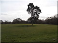
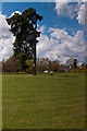
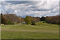
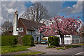
Three bronze age barrows, located beside the Earlswood Common golf course and nature reserve. The most obvious is located beside the road between St John's and Meadvale, due to the large Victorian pine tree growing from the barrow.
I have yet to discover the definitive location of the other two barrows, but the offical Reigate and Banstead Borough Council area guide explicitly states that they exist. A second possible barrow lies a few metres south of the main barrow. The guide also states that bronze age artefacts have been discovered on the common.
You may be viewing yesterday's version of this page. To see the most up to date information please register for a free account.
Do not use the above information on other web sites or publications without permission of the contributor.
Nearby Images from Geograph Britain and Ireland:
©2015(licence)
©2012(licence)
©2015(licence)
©2012(licence)
©2012(licence)
The above images may not be of the site on this page, they are loaded from Geograph.
Please Submit an Image of this site or go out and take one for us!
Click here to see more info for this site
Nearby sites
Key: Red: member's photo, Blue: 3rd party photo, Yellow: other image, Green: no photo - please go there and take one, Grey: site destroyed
Download sites to:
KML (Google Earth)
GPX (GPS waypoints)
CSV (Garmin/Navman)
CSV (Excel)
To unlock full downloads you need to sign up as a Contributory Member. Otherwise downloads are limited to 50 sites.
Turn off the page maps and other distractions
Nearby sites listing. In the following links * = Image available
1.3km NE 40° Redhill Common* Round Barrow(s) (TQ274496)
1.7km NNE 26° Whitepost Hill Spring Holy Well or Sacred Spring (TQ273501)
1.7km E 88° Royal Earlswood Stones* Modern Stone Circle etc (TQ283487)
1.7km NNE 22° Waterslade Spring Holy Well or Sacred Spring (TQ272502)
3.4km NW 304° Reigate Heath Barrows* Barrow Cemetery (TQ23725042)
4.1km N 8° Gatton Park, The Millennium Stones* Modern Stone Circle etc (TQ271527)
6.7km N 355° St. Margaret's Well (Mugswell)* Holy Well or Sacred Spring (TQ258553)
7.1km NE 52° Spring Bottom* Holy Well or Sacred Spring (TQ321531)
7.1km ENE 63° North Park Farm* Ancient Village or Settlement (TQ329520)
7.9km NE 55° War Coppice Camp* Hillfort (TQ3298053260)
8.3km NNE 32° St Peter and St Paul's Church (Chaldon)* Ancient Cross (TQ3087455694)
8.3km N 10° Chipstead Well Holy Well or Sacred Spring (TQ278568)
8.5km WNW 290° Box Hill Bowl Barrow 2* Round Barrow(s) (TQ18575132)
8.8km ENE 71° Godstone Tumulus* Artificial Mound (TQ349517)
8.9km WNW 288° Box Hill Bowl Barrow 1* Round Barrow(s) (TQ18065121)
9.5km W 271° Glory Wood Bowl Barrow* Round Barrow(s) (TQ1712248542)
9.5km ENE 74° St Mary's Well (Godstone)* Holy Well or Sacred Spring (TQ357515)
9.6km ENE 74° Walker Miles Memorial* Modern Stone Circle etc (TQ358515)
9.7km ENE 78° Diana's Well Holy Well or Sacred Spring (TQ361508)
9.8km NNE 22° Farthing Downs* Barrow Cemetery (TQ300578)
9.8km ENE 78° Leigh Place Stone* Natural Stone / Erratic / Other Natural Feature (TQ362509)
10.2km NW 308° Cherkley Court Barrows* Round Barrow(s) (TQ18385467)
10.3km NW 316° Thirty Acre Barn Barrows Round Barrow(s) (TQ192558)
10.7km N 349° Tumble Beacon Round Barrow(s) (TQ24325902)
11.3km W 273° Milton Heath* Round Barrow(s) (TQ15294890)
View more nearby sites and additional images


 We would like to know more about this location. Please feel free to add a brief description and any relevant information in your own language.
 Wir möchten mehr über diese Stätte erfahren. Bitte zögern Sie nicht, eine kurze Beschreibung und relevante Informationen in Deutsch hinzuzufügen.
 Nous aimerions en savoir encore un peu sur les lieux. S'il vous plaît n'hesitez pas à ajouter une courte description et tous les renseignements pertinents dans votre propre langue.
 Quisieramos informarnos un poco más de las lugares. No dude en añadir una breve descripción y otros datos relevantes en su propio idioma.