

<< Our Photo Pages >> Knatten - Barrow Cemetery in Norway in Buskerud
Submitted by kenntha88 on Wednesday, 26 October 2022 Page Views: 394
Neolithic and Bronze AgeSite Name: KnattenCountry: Norway
NOTE: This site is 7.022 km away from the location you searched for.
Fylke: Buskerud Type: Barrow Cemetery
Nearest Town: Kongsberg
Latitude: 59.602226N Longitude: 9.665836E
Condition:
| 5 | Perfect |
| 4 | Almost Perfect |
| 3 | Reasonable but with some damage |
| 2 | Ruined but still recognisable as an ancient site |
| 1 | Pretty much destroyed, possibly visible as crop marks |
| 0 | No data. |
| -1 | Completely destroyed |
| 5 | Superb |
| 4 | Good |
| 3 | Ordinary |
| 2 | Not Good |
| 1 | Awful |
| 0 | No data. |
| 5 | Can be driven to, probably with disabled access |
| 4 | Short walk on a footpath |
| 3 | Requiring a bit more of a walk |
| 2 | A long walk |
| 1 | In the middle of nowhere, a nightmare to find |
| 0 | No data. |
| 5 | co-ordinates taken by GPS or official recorded co-ordinates |
| 4 | co-ordinates scaled from a detailed map |
| 3 | co-ordinates scaled from a bad map |
| 2 | co-ordinates of the nearest village |
| 1 | co-ordinates of the nearest town |
| 0 | no data |
Internal Links:
External Links:
")
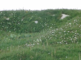
The barrow cemetery consists of 13 round barrows. The cemetery is oriented in a semi circle from east to west along the edge of a natural plateau overlooking the river valley to the north and north east. Several barrows have been damaged by nearby houses and roads to these. Only the west part of the cemetery had a little less vegetation and the barrows here could easily be found though they are also overgrown with smaller and larger trees and moss.
The three largest barrows are 17-20 metres in diameter and 1 to 1,75 metres in height. The two largest barrows have craters dug into the top and have ditches around them. The barrows are relatively low compared to the diameter. The rest of the barrows are 6-9 metres in diameter. Between the houses there is a footpath that goes trough the west part of the cemetery. When one of the nearby houses was built it was found a flat ground burial with burned human bones but no artifacts.
You may be viewing yesterday's version of this page. To see the most up to date information please register for a free account.
")
")
")
")
Do not use the above information on other web sites or publications without permission of the contributor.
Nearby Images from Flickr


The above images may not be of the site on this page, but were taken nearby. They are loaded from Flickr so please click on them for image credits.
Click here to see more info for this site
Nearby sites
Click here to view sites on an interactive map of the areaKey: Red: member's photo, Blue: 3rd party photo, Yellow: other image, Green: no photo - please go there and take one, Grey: site destroyed
Download sites to:
KML (Google Earth)
GPX (GPS waypoints)
CSV (Garmin/Navman)
CSV (Excel)
To unlock full downloads you need to sign up as a Contributory Member. Otherwise downloads are limited to 50 sites.
Turn off the page maps and other distractions
Nearby sites listing. In the following links * = Image available
6.6km ENE 75° Tjuvberget* Hillfort
6.6km ESE 104° Gunnes* Barrow Cemetery
6.7km ESE 105° Hostvetveien-Evju* Barrow Cemetery
7.6km ESE 112° Evju* Barrow Cemetery
14.9km SE 129° Tjuvbørje* Hillfort
18.1km NE 41° Besseberghaugen* Barrow Cemetery
24.3km ESE 107° Hof Skole* Barrow Cemetery
24.3km ESE 102° Østby-Kopstadlinna* Barrow Cemetery
25.4km NNE 22° Myremoen* Stone Circle
25.7km NNE 22° Myreslottet* Hillfort
25.8km ESE 108° Haugestad* Barrow Cemetery
26.0km ESE 111° Rønneberg* Barrow Cemetery
26.3km W 263° Semhaugen* Round Barrow(s)
26.9km SE 139° Pålrønningen* Barrow Cemetery
27.0km ENE 69° Andorsrud* Hillfort
28.1km ESE 104° Stufsrudborgen Hillfort* Hillfort
28.8km SW 224° Briskemoen* Barrow Cemetery
30.5km E 92° Hammerøi Mound* Round Barrow(s)
31.2km ESE 118° Holmsvatnet-Tjuvberget Hillfort* Hillfort
31.6km E 93° Duni* Barrow Cemetery
33.8km ENE 66° Skogerveien* Rock Art
34.9km S 176° Siljuhaugen* Round Barrow(s)
35.6km SW 228° Nesbyen-Tinghaug* Modern Stone Circle etc
35.8km ENE 69° Åskollen* Rock Art
35.8km WSW 236° Gullhaugen-Alstadhaug* Round Barrow(s)
View more nearby sites and additional images


 We would like to know more about this location. Please feel free to add a brief description and any relevant information in your own language.
 Wir möchten mehr über diese Stätte erfahren. Bitte zögern Sie nicht, eine kurze Beschreibung und relevante Informationen in Deutsch hinzuzufügen.
 Nous aimerions en savoir encore un peu sur les lieux. S'il vous plaît n'hesitez pas à ajouter une courte description et tous les renseignements pertinents dans votre propre langue.
 Quisieramos informarnos un poco más de las lugares. No dude en añadir una breve descripción y otros datos relevantes en su propio idioma.