


<< Our Photo Pages >> Kushavarta Teerth - Ancient Temple in India
Submitted by motist on Thursday, 03 June 2010 Page Views: 6270
Multi-periodSite Name: Kushavarta TeerthCountry: India
NOTE: This site is 99.827 km away from the location you searched for.
Type: Ancient Temple
Nearest Town: Trimbak
Latitude: 19.929766N Longitude: 73.528915E
Condition:
| 5 | Perfect |
| 4 | Almost Perfect |
| 3 | Reasonable but with some damage |
| 2 | Ruined but still recognisable as an ancient site |
| 1 | Pretty much destroyed, possibly visible as crop marks |
| 0 | No data. |
| -1 | Completely destroyed |
| 5 | Superb |
| 4 | Good |
| 3 | Ordinary |
| 2 | Not Good |
| 1 | Awful |
| 0 | No data. |
| 5 | Can be driven to, probably with disabled access |
| 4 | Short walk on a footpath |
| 3 | Requiring a bit more of a walk |
| 2 | A long walk |
| 1 | In the middle of nowhere, a nightmare to find |
| 0 | No data. |
| 5 | co-ordinates taken by GPS or official recorded co-ordinates |
| 4 | co-ordinates scaled from a detailed map |
| 3 | co-ordinates scaled from a bad map |
| 2 | co-ordinates of the nearest village |
| 1 | co-ordinates of the nearest town |
| 0 | no data |
Internal Links:
External Links:
")
Kushavarta Teerth is a bathing tank located at Trimbakeshwar in Nasik District of Maharashtra. Kushavarta is the place from where the Godavari River originates.
People believe that a dip in this sacred tank wipes off ones sins. This teerth is said to be the spot where Gautam Rishi finally secured the Ganges River on earth by spreading the Kusha or the Darba grass around the river.
The structure around the Kushavarta Teerth was built in the late 18th century by Raoji Abaji Parnekar of the Holkars, the Maratha rulers of Indore. This holy tank has flights of steps on all sides with pillared aisles, and highly ornate arches.
Trimbakeshwar Temple and Indra Teerth are the important places of tourist interest situated nearby.
More : http://www.mahashivratri.org/trimbakeshwar-temple-nasik.html
http://en.wikipedia.org/wiki/Trimbakeshwar_Shiva_Temple
http://divineindia.blog.co.in/2009/08/03/trimbakeshwar-jyotirlinga/
You may be viewing yesterday's version of this page. To see the most up to date information please register for a free account.
")
")
")
Do not use the above information on other web sites or publications without permission of the contributor.
Nearby Images from Flickr

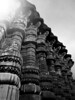
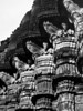

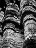
The above images may not be of the site on this page, but were taken nearby. They are loaded from Flickr so please click on them for image credits.
Click here to see more info for this site
Nearby sites
Click here to view sites on an interactive map of the areaKey: Red: member's photo, Blue: 3rd party photo, Yellow: other image, Green: no photo - please go there and take one, Grey: site destroyed
Download sites to:
KML (Google Earth)
GPX (GPS waypoints)
CSV (Garmin/Navman)
CSV (Excel)
To unlock full downloads you need to sign up as a Contributory Member. Otherwise downloads are limited to 50 sites.
Turn off the page maps and other distractions
Nearby sites listing. In the following links * = Image available
98m SSW 205° Trimbakeshwar Temple* Ancient Temple
23.0km E 87° Pandu Lena* Ancient Temple
28.8km ENE 73° Nashik- Kumbh Mela city* Ancient Temple
103.5km SW 221° Mandapeshwar Caves Ancient Temple
103.5km SW 219° Kanheri Cave Temples* Ancient Temple
112.4km SW 218° Mahakali Caves Ancient Temple
112.6km SW 219° Jogeshwari Caves Ancient Temple
124.4km SSW 210° Elephanta Cave Temples* Ancient Temple
127.7km S 183° Karla caves* Rock Art
131.4km S 180° Bedse Cave Temples* Ancient Temple
133.8km S 182° Bhaja Cave Temples* Ancient Temple
159.6km SSE 168° Pataleshwar cave temple * Ancient Temple
171.7km E 86° Ellora cave temples* Ancient Temple
171.8km E 86° Grishneshwar Jyotirlinga Temple* Ancient Temple
186.4km E 90° Aurangabad Caves* Ancient Temple
236.9km ENE 73° Ajanta Caves* Cave or Rock Shelter
297.2km NNE 26° Bagh Cave Temples* Ancient Temple
317.3km NNW 336° Lothal* Ancient Village or Settlement
342.9km WNW 289° Somnath Jyotirlinga temple* Ancient Temple
359.5km WNW 300° Girnar -Jungadh* Ancient Temple
401.9km NNW 328° Dhrangadhra* Standing Stone (Menhir)
404.7km NNW 328° Little Rann of Kutch* Standing Stones
429.8km NNE 32° Ujjain* Ancient Temple
461.5km NNW 327° Mehardak Bet Alignment* Stone Row / Alignment
461.5km NNW 327° Mehardak Bet Temple* Ancient Temple
View more nearby sites and additional images


 We would like to know more about this location. Please feel free to add a brief description and any relevant information in your own language.
 Wir möchten mehr über diese Stätte erfahren. Bitte zögern Sie nicht, eine kurze Beschreibung und relevante Informationen in Deutsch hinzuzufügen.
 Nous aimerions en savoir encore un peu sur les lieux. S'il vous plaît n'hesitez pas à ajouter une courte description et tous les renseignements pertinents dans votre propre langue.
 Quisieramos informarnos un poco más de las lugares. No dude en añadir una breve descripción y otros datos relevantes en su propio idioma.