<< Our Photo Pages >> The Troll's Arrow - Standing Stone (Menhir) in Norway in Møre og Romsdal
Submitted by kenntha88 on Monday, 10 August 2009 Page Views: 4028
Neolithic and Bronze AgeSite Name: The Troll's Arrow Alternative Name: BolsøyaCountry: Norway
NOTE: This site is 6.134 km away from the location you searched for.
Fylke: Møre og Romsdal Type: Standing Stone (Menhir)
Nearest Town: Molde
Latitude: 62.731032N Longitude: 7.328010E
Condition:
| 5 | Perfect |
| 4 | Almost Perfect |
| 3 | Reasonable but with some damage |
| 2 | Ruined but still recognisable as an ancient site |
| 1 | Pretty much destroyed, possibly visible as crop marks |
| 0 | No data. |
| -1 | Completely destroyed |
| 5 | Superb |
| 4 | Good |
| 3 | Ordinary |
| 2 | Not Good |
| 1 | Awful |
| 0 | No data. |
| 5 | Can be driven to, probably with disabled access |
| 4 | Short walk on a footpath |
| 3 | Requiring a bit more of a walk |
| 2 | A long walk |
| 1 | In the middle of nowhere, a nightmare to find |
| 0 | No data. |
| 5 | co-ordinates taken by GPS or official recorded co-ordinates |
| 4 | co-ordinates scaled from a detailed map |
| 3 | co-ordinates scaled from a bad map |
| 2 | co-ordinates of the nearest village |
| 1 | co-ordinates of the nearest town |
| 0 | no data |
Internal Links:
External Links:
")
It is called The Trolls Arrow because in an old tale say it was a troll living in the mountains further south that shot an arrow to try to hit the newly built church on the small Island, but it missed and the arrow went down into the ground at Bolsøya, and is since then called the Trolls Arrow.
There has been many large burial mounds around it, but most of them are now destroyed or flattened by farming.
Luckilly the standing stone survived and it's a very nice and beautiful reminder of the iron age settlement here.
You may be viewing yesterday's version of this page. To see the most up to date information please register for a free account.
")
")
")
Do not use the above information on other web sites or publications without permission of the contributor.
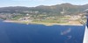
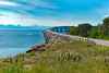
Nearby Images from Flickr
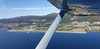
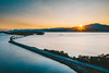
![Bols�y Bridge | Norway aerial #215/365 [Explored]](https://farm66.static.flickr.com/65535/48517196496_b566d41277_t.jpg)
The above images may not be of the site on this page, but were taken nearby. They are loaded from Flickr so please click on them for image credits.
Click here to see more info for this site
Nearby sites
Click here to view sites on an interactive map of the areaKey: Red: member's photo, Blue: 3rd party photo, Yellow: other image, Green: no photo - please go there and take one, Grey: site destroyed
Download sites to:
KML (Google Earth)
GPX (GPS waypoints)
CSV (Garmin/Navman)
CSV (Excel)
To unlock full downloads you need to sign up as a Contributory Member. Otherwise downloads are limited to 50 sites.
Turn off the page maps and other distractions
Nearby sites listing. In the following links * = Image available
203m E 89° Jutahaugen* Stone Circle
4.9km SSE 152° Nesje Standing Stones* Standing Stones
9.9km E 100° Horga Pagan Altar* Sculptured Stone
14.1km S 185° Reiestad Standing Stone* Standing Stone (Menhir)
14.2km S 180° Grandan Mounds* Round Barrow(s)
15.9km S 175° Våge standing stone* Standing Stone (Menhir)
17.3km SW 216° Kråkneset Cairns* Cairn
18.3km WNW 302° Reithaugen Round Barrow(s)
21.7km WNW 299° Hoksnes* Standing Stone (Menhir)
21.9km WNW 285° Prestegardsskogen* Round Barrow(s)
22.1km WNW 283° Tangen (Aukra)* Round Barrow(s)
24.4km NNE 21° Håkonrøysa* Cairn
26.6km NW 315° Gule* Standing Stone (Menhir)
27.8km WSW 249° Naustvollen* Standing Stone (Menhir)
28.1km WNW 288° Korsbø-Smøla* Standing Stones
28.9km NNW 334° Malefeten* Barrow Cemetery
29.5km NNW 345° Sandvikshagen* Barrow Cemetery
31.0km N 357° Rullesteinshaugen* Cairn
34.0km NE 38° Ikornneset* Barrow Cemetery
35.9km SE 141° Horgheim Gravfelt* Barrow Cemetery
36.0km NNE 18° Søfstadklubben* Rock Art
36.5km NNE 33° Kvernes Tingsted* Stone Circle
38.3km E 88° Boggestranda* Carving
40.5km NE 36° Frei Standing Stones* Standing Stones
42.9km NE 42° Aspa Standing Stones* Standing Stones
View more nearby sites and additional images


 We would like to know more about this location. Please feel free to add a brief description and any relevant information in your own language.
 Wir möchten mehr über diese Stätte erfahren. Bitte zögern Sie nicht, eine kurze Beschreibung und relevante Informationen in Deutsch hinzuzufügen.
 Nous aimerions en savoir encore un peu sur les lieux. S'il vous plaît n'hesitez pas à ajouter une courte description et tous les renseignements pertinents dans votre propre langue.
 Quisieramos informarnos un poco más de las lugares. No dude en añadir una breve descripción y otros datos relevantes en su propio idioma.