<< Our Photo Pages >> Larsnes Standing Stones - Standing Stones in Norway in Møre og Romsdal
Submitted by kenntha88 on Tuesday, 11 September 2012 Page Views: 2123
Neolithic and Bronze AgeSite Name: Larsnes Standing StonesCountry: Norway
NOTE: This site is 15.823 km away from the location you searched for.
Fylke: Møre og Romsdal Type: Standing Stones
Nearest Village: Ulsteinvik
Latitude: 62.206145N Longitude: 5.567740E
Condition:
| 5 | Perfect |
| 4 | Almost Perfect |
| 3 | Reasonable but with some damage |
| 2 | Ruined but still recognisable as an ancient site |
| 1 | Pretty much destroyed, possibly visible as crop marks |
| 0 | No data. |
| -1 | Completely destroyed |
| 5 | Superb |
| 4 | Good |
| 3 | Ordinary |
| 2 | Not Good |
| 1 | Awful |
| 0 | No data. |
| 5 | Can be driven to, probably with disabled access |
| 4 | Short walk on a footpath |
| 3 | Requiring a bit more of a walk |
| 2 | A long walk |
| 1 | In the middle of nowhere, a nightmare to find |
| 0 | No data. |
| 5 | co-ordinates taken by GPS or official recorded co-ordinates |
| 4 | co-ordinates scaled from a detailed map |
| 3 | co-ordinates scaled from a bad map |
| 2 | co-ordinates of the nearest village |
| 1 | co-ordinates of the nearest town |
| 0 | no data |
Internal Links:
External Links:
")
On a stony hill overlooking the small harbor of Larsnes are two standing stones. One of them still standing, the other one has broken off near the base and sadly today is laying down.
The stone still standing has the shape of a small slab, its around 1,40m high, around 40cm wide and about 10cm wide. It has been raised by wedging it inside a natural crack in the rock, therefore it doesn't seem to be a barrow or a grave marker, but could be a memory stone.
The site lies close to a private garden just north of a harbour industry building. It is a very nice view from the top of the rock hill and over the ocean.
You may be viewing yesterday's version of this page. To see the most up to date information please register for a free account.
")
")
")
Do not use the above information on other web sites or publications without permission of the contributor.
Nearby Images from Flickr

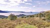
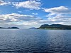


The above images may not be of the site on this page, but were taken nearby. They are loaded from Flickr so please click on them for image credits.
Click here to see more info for this site
Nearby sites
Click here to view sites on an interactive map of the areaKey: Red: member's photo, Blue: 3rd party photo, Yellow: other image, Green: no photo - please go there and take one, Grey: site destroyed
Download sites to:
KML (Google Earth)
GPX (GPS waypoints)
CSV (Garmin/Navman)
CSV (Excel)
To unlock full downloads you need to sign up as a Contributory Member. Otherwise downloads are limited to 50 sites.
Turn off the page maps and other distractions
Nearby sites listing. In the following links * = Image available
15.8km ENE 70° Selvåg standing stone* Standing Stone (Menhir)
20.4km NE 41° Osnes Standing Stone* Standing Stone (Menhir)
20.5km NE 41° Oshaugen cairn* Cairn
20.8km SSW 213° Selje barrow cemetery* Barrow Cemetery
21.4km NE 38° Ryssholmen Standing Stone* Standing Stone (Menhir)
21.5km NE 37° Laberget standing stone* Standing Stone (Menhir)
21.7km E 84° Steinneset standing stones* Standing Stones
25.7km SSW 211° Barmen Runestone* Carving
25.9km SSW 211° Hornsetra standing stone* Standing Stone (Menhir)
26.9km SSW 211° Korsneset standing stone* Standing Stone (Menhir)
29.9km NE 53° Hareid standing stones* Standing Stones
30.5km ENE 58° Hjørungavåg standing stones* Standing Stones
35.3km SSE 155° Viljane standing stone* Standing Stone (Menhir)
35.4km SSE 156° Naustdal standing stone* Standing Stone (Menhir)
37.5km NE 34° Alnestrøya standing stone* Standing Stone (Menhir)
37.5km NE 39° Hogsteinneset standing stones* Standing Stones
37.6km NE 39° Eilifrøysa Gravhaug* Cairn
39.6km SE 146° Myklebust Round Barrows* Round Barrow(s)
41.0km NE 37° Giske standing stone* Standing Stone (Menhir)
41.6km NE 38° Mjeltehaugen Barrow* Artificial Mound
44.0km NNE 33° Synes standing stone* Standing Stone (Menhir)
44.5km NE 38° Skjonghelleren* Cave or Rock Shelter
45.5km SSW 198° Vingen* Rock Art
47.3km NNE 32° Sjøskardet standing stone* Standing Stone (Menhir)
47.4km NNE 32° Blimshaugen mound* Round Barrow(s)
View more nearby sites and additional images


 We would like to know more about this location. Please feel free to add a brief description and any relevant information in your own language.
 Wir möchten mehr über diese Stätte erfahren. Bitte zögern Sie nicht, eine kurze Beschreibung und relevante Informationen in Deutsch hinzuzufügen.
 Nous aimerions en savoir encore un peu sur les lieux. S'il vous plaît n'hesitez pas à ajouter une courte description et tous les renseignements pertinents dans votre propre langue.
 Quisieramos informarnos un poco más de las lugares. No dude en añadir una breve descripción y otros datos relevantes en su propio idioma.