<< Our Photo Pages >> Oshaugen cairn - Cairn in Norway in Møre og Romsdal
Submitted by kenntha88 on Wednesday, 12 September 2012 Page Views: 1673
Neolithic and Bronze AgeSite Name: Oshaugen cairnCountry: Norway Fylke: Møre og Romsdal Type: Cairn
Nearest Town: Ålesund Nearest Village: Ulsteinvik
Latitude: 62.345773N Longitude: 5.827067E
Condition:
| 5 | Perfect |
| 4 | Almost Perfect |
| 3 | Reasonable but with some damage |
| 2 | Ruined but still recognisable as an ancient site |
| 1 | Pretty much destroyed, possibly visible as crop marks |
| 0 | No data. |
| -1 | Completely destroyed |
| 5 | Superb |
| 4 | Good |
| 3 | Ordinary |
| 2 | Not Good |
| 1 | Awful |
| 0 | No data. |
| 5 | Can be driven to, probably with disabled access |
| 4 | Short walk on a footpath |
| 3 | Requiring a bit more of a walk |
| 2 | A long walk |
| 1 | In the middle of nowhere, a nightmare to find |
| 0 | No data. |
| 5 | co-ordinates taken by GPS or official recorded co-ordinates |
| 4 | co-ordinates scaled from a detailed map |
| 3 | co-ordinates scaled from a bad map |
| 2 | co-ordinates of the nearest village |
| 1 | co-ordinates of the nearest town |
| 0 | no data |
Internal Links:
External Links:
")
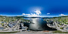
The Oshaugen cairn is the largest burial cairn in western Norway. It has a diameter of 45 metres and a height of about 6 metres. Buildt on top of a round natural hill it looks even larger and is an impressive sight! From the top of the cairn is a magnificent view over the ocean!
The cairn was excavated in 1837. They lasted all until 1860. A small burial chamber was found, but still they didnt reach the bottom. A small finger ring of gold from around 300AD was found between the rocks. Just one similar ring from Uppsala, Sweden is known.
Large burial cairns are usually dated to older bronze age, around 1700 BC. The gold ring is probably from a younger burial inside or near the cairn. There was originally a circle of stones close to the cairn and a small path of stone slabs lead from the stone circle to the cairn. These have sadly been lost in later years.
The large gold ring and the large burial monument suggests that there was a powerful settlement in the early bronze age and older iron age in the area. In a excavation nearby, it was found pieces of imported decorated glass cups.
You may be viewing yesterday's version of this page. To see the most up to date information please register for a free account.
")
")
Do not use the above information on other web sites or publications without permission of the contributor.
Nearby Images from Flickr


The above images may not be of the site on this page, but were taken nearby. They are loaded from Flickr so please click on them for image credits.
Click here to see more info for this site
Nearby sites
Click here to view sites on an interactive map of the areaKey: Red: member's photo, Blue: 3rd party photo, Yellow: other image, Green: no photo - please go there and take one, Grey: site destroyed
Download sites to:
KML (Google Earth)
GPX (GPS waypoints)
CSV (Garmin/Navman)
CSV (Excel)
To unlock full downloads you need to sign up as a Contributory Member. Otherwise downloads are limited to 50 sites.
Turn off the page maps and other distractions
Nearby sites listing. In the following links * = Image available
186m SSE 162° Osnes Standing Stone* Standing Stone (Menhir)
1.4km NNW 348° Ryssholmen Standing Stone* Standing Stone (Menhir)
1.5km NNW 347° Laberget standing stone* Standing Stone (Menhir)
10.3km S 172° Selvåg standing stone* Standing Stone (Menhir)
10.7km ENE 77° Hareid standing stones* Standing Stones
12.5km E 87° Hjørungavåg standing stones* Standing Stones
15.5km SSE 148° Steinneset standing stones* Standing Stones
17.0km NE 38° Hogsteinneset standing stones* Standing Stones
17.1km NE 38° Eilifrøysa Gravhaug* Cairn
17.3km NNE 26° Alnestrøya standing stone* Standing Stone (Menhir)
20.5km SW 221° Larsnes Standing Stones* Standing Stones
20.5km NE 34° Giske standing stone* Standing Stone (Menhir)
21.1km NE 35° Mjeltehaugen Barrow* Artificial Mound
23.9km NNE 26° Synes standing stone* Standing Stone (Menhir)
24.0km NE 36° Skjonghelleren* Cave or Rock Shelter
27.2km NNE 25° Sjøskardet standing stone* Standing Stone (Menhir)
27.3km NNE 26° Blimshaugen mound* Round Barrow(s)
41.3km SW 217° Selje barrow cemetery* Barrow Cemetery
46.1km SW 216° Barmen Runestone* Carving
46.2km SW 216° Hornsetra standing stone* Standing Stone (Menhir)
47.2km SW 215° Korsneset standing stone* Standing Stone (Menhir)
47.6km S 179° Viljane standing stone* Standing Stone (Menhir)
47.9km S 179° Naustdal standing stone* Standing Stone (Menhir)
49.3km S 170° Myklebust Round Barrows* Round Barrow(s)
57.1km SSE 167° Heksesteinen* Carving
View more nearby sites and additional images


 We would like to know more about this location. Please feel free to add a brief description and any relevant information in your own language.
 Wir möchten mehr über diese Stätte erfahren. Bitte zögern Sie nicht, eine kurze Beschreibung und relevante Informationen in Deutsch hinzuzufügen.
 Nous aimerions en savoir encore un peu sur les lieux. S'il vous plaît n'hesitez pas à ajouter une courte description et tous les renseignements pertinents dans votre propre langue.
 Quisieramos informarnos un poco más de las lugares. No dude en añadir una breve descripción y otros datos relevantes en su propio idioma.