<< Text Pages >> Hasanlu Tepe - Ancient Village or Settlement in Iran
Submitted by Andy B on Sunday, 20 November 2011 Page Views: 4314
DigsSite Name: Hasanlu Tepe Alternative Name: Teppe Hasanlu, Tappeh Hassanlu, Persian: تپه حسنلوCountry: Iran
NOTE: This site is 54.119 km away from the location you searched for.
Type: Ancient Village or Settlement
Latitude: 37.004831N Longitude: 45.458892E
Condition:
| 5 | Perfect |
| 4 | Almost Perfect |
| 3 | Reasonable but with some damage |
| 2 | Ruined but still recognisable as an ancient site |
| 1 | Pretty much destroyed, possibly visible as crop marks |
| 0 | No data. |
| -1 | Completely destroyed |
| 5 | Superb |
| 4 | Good |
| 3 | Ordinary |
| 2 | Not Good |
| 1 | Awful |
| 0 | No data. |
| 5 | Can be driven to, probably with disabled access |
| 4 | Short walk on a footpath |
| 3 | Requiring a bit more of a walk |
| 2 | A long walk |
| 1 | In the middle of nowhere, a nightmare to find |
| 0 | No data. |
| 5 | co-ordinates taken by GPS or official recorded co-ordinates |
| 4 | co-ordinates scaled from a detailed map |
| 3 | co-ordinates scaled from a bad map |
| 2 | co-ordinates of the nearest village |
| 1 | co-ordinates of the nearest town |
| 0 | no data |
Internal Links:
External Links:
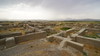
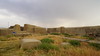
Teppe Hasanlu is an archeological site of an ancient city located in northwest Iran (in the province of West Azarbaijan), a short distance south of Lake Urmia. The nature of its destruction at the end of the 9th century BC essentially froze one layer of the city in time, providing researchers with extremely well preserved buildings, artifacts, and skeletal remains from the victims and enemy combatants of the attack.
Hasanlu Tepe is the largest site in the Gadar River valley and dominates the small plain known as Solduz. The site consists of a 25m high central "citadel" mound, with massive fortifications and paved streets, surrounded by a low outer town, 8m above the surrounding plain. The entire site, once much larger but reduced in size by local agricultural and building activities, now measures about 600m across, with the citadel having a diameter of about 200 m.
The site was inhabited fairly continuously from the 6th millennium BC to the 3rd century AD. It is famous for the "Gold Bowl" found by a team from the University of Pennsylvania led by Robert Dyson
More at Wikipedia
You may be viewing yesterday's version of this page. To see the most up to date information please register for a free account.
Do not use the above information on other web sites or publications without permission of the contributor.
Nearby Images from Flickr
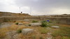
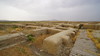
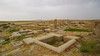
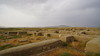
The above images may not be of the site on this page, but were taken nearby. They are loaded from Flickr so please click on them for image credits.
Click here to see more info for this site
Nearby sites
Click here to view sites on an interactive map of the areaKey: Red: member's photo, Blue: 3rd party photo, Yellow: other image, Green: no photo - please go there and take one, Grey: site destroyed
Download sites to:
KML (Google Earth)
GPX (GPS waypoints)
CSV (Garmin/Navman)
CSV (Excel)
To unlock full downloads you need to sign up as a Contributory Member. Otherwise downloads are limited to 50 sites.
Turn off the page maps and other distractions
Nearby sites listing. In the following links * = Image available
1.8km SE 130° Hajji Firuz Tepe Ancient Village or Settlement
111.9km WSW 259° Shanidar Cave Cave or Rock Shelter
139.4km NNE 32° Yanik Tepe Ancient Village or Settlement
142.8km SSW 209° Satu Qala (Idu)* Ancient Village or Settlement
159.0km SW 235° Arbil, Iraq* Ancient Village or Settlement
165.1km WNW 293° Tirsin Plateau Rock Art
200.6km NW 313° Yurtbasi Hillfort
204.4km WSW 256° Tepe Gawra Ancient Village or Settlement
206.1km WSW 255° Dur-Sharrukin* Ancient Village or Settlement
215.3km WSW 243° Nimrud* Ancient Village or Settlement
217.2km WSW 252° Nineveh* Ancient Village or Settlement
218.4km SSW 210° Nuzi Ancient Village or Settlement
224.2km SW 217° Tell al-Fakhar Ancient Palace
231.2km NW 311° Sardurihinili* Ancient Palace
245.7km NW 315° Anzaf Hillfort
247.2km NW 314° Rusahinili* Hillfort
248.2km NW 308° Samran Channel* Ancient Mine, Quarry or other Industry
249.8km N 359° Duzdag Ancient Mine, Quarry or other Industry
249.8km NW 313° Urartu Museum Museum
250.2km NW 312° Tushpa* Ancient Village or Settlement
253.0km SSE 148° Rabat Tepe Ancient Village or Settlement
253.0km NW 314° Kalecik Stones Standing Stones
259.2km E 95° Chehr-Abad Salt Mine Ancient Mine, Quarry or other Industry
260.0km NW 325° Körzüt Castle* Hillfort
261.6km SW 230° Assur (Iraq)* Ancient Village or Settlement
View more nearby sites and additional images


 We would like to know more about this location. Please feel free to add a brief description and any relevant information in your own language.
 Wir möchten mehr über diese Stätte erfahren. Bitte zögern Sie nicht, eine kurze Beschreibung und relevante Informationen in Deutsch hinzuzufügen.
 Nous aimerions en savoir encore un peu sur les lieux. S'il vous plaît n'hesitez pas à ajouter une courte description et tous les renseignements pertinents dans votre propre langue.
 Quisieramos informarnos un poco más de las lugares. No dude en añadir una breve descripción y otros datos relevantes en su propio idioma.