

<< Text Pages >> Waru Cup Mark Stone - Rock Art in Nigeria
Submitted by KaiHofmann on Tuesday, 24 September 2013 Page Views: 2329
Rock ArtSite Name: Waru Cup Mark StoneCountry: Nigeria
NOTE: This site is 528.561 km away from the location you searched for.
Type: Rock Art
Nearest Town: Abuja Nearest Village: Orozo
Latitude: 8.912937N Longitude: 7.496177E
Condition:
| 5 | Perfect |
| 4 | Almost Perfect |
| 3 | Reasonable but with some damage |
| 2 | Ruined but still recognisable as an ancient site |
| 1 | Pretty much destroyed, possibly visible as crop marks |
| 0 | No data. |
| -1 | Completely destroyed |
| 5 | Superb |
| 4 | Good |
| 3 | Ordinary |
| 2 | Not Good |
| 1 | Awful |
| 0 | No data. |
| 5 | Can be driven to, probably with disabled access |
| 4 | Short walk on a footpath |
| 3 | Requiring a bit more of a walk |
| 2 | A long walk |
| 1 | In the middle of nowhere, a nightmare to find |
| 0 | No data. |
| 5 | co-ordinates taken by GPS or official recorded co-ordinates |
| 4 | co-ordinates scaled from a detailed map |
| 3 | co-ordinates scaled from a bad map |
| 2 | co-ordinates of the nearest village |
| 1 | co-ordinates of the nearest town |
| 0 | no data |
Be the first person to rate this site - see the 'Contribute!' box in the right hand menu.
Internal Links:
External Links:
Rock Art in Nigeria
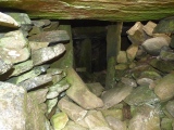
Cup marked stone east of a stone quarry. It could be a possible destruction of the site by the quarrymen.
You may be viewing yesterday's version of this page. To see the most up to date information please register for a free account.
Do not use the above information on other web sites or publications without permission of the contributor.
Click here to see more info for this site
Nearby sites
Click here to view sites on an interactive map of the areaKey: Red: member's photo, Blue: 3rd party photo, Yellow: other image, Green: no photo - please go there and take one, Grey: site destroyed
Download sites to:
KML (Google Earth)
GPX (GPS waypoints)
CSV (Garmin/Navman)
CSV (Excel)
To unlock full downloads you need to sign up as a Contributory Member. Otherwise downloads are limited to 50 sites.
Turn off the page maps and other distractions
Nearby sites listing. In the following links * = Image available
22.2km NNW 329° Jabi Cup Mark Stone Rock Art
32.0km NNW 343° Abuja Cup Mark Stone Rock Art
85.6km NE 40° Taruga* Ancient Village or Settlement
342.3km SSE 161° Ikom Monoliths* Standing Stones
886.5km N 9° Gobero Barrow Cemetery
930.2km NNE 16° Gobero Barrow Cemetery
1042.5km N 2° Air Giraffe Rock Art Rock Art
1127.1km NNE 14° Adrar Madet (Massif) Stone Circle Stone Circle
1292.5km NNW 332° Adrar des Ifoghas petroglyphs Rock Art
1292.9km SW 220° Why you should eat fish: twelve good reasons NOT SET
1292.9km SW 220° 13,000 Native American artifacts stolen from Southern Illinois refuge NOT SET
1292.9km SW 220° Relax On A Budget As You Travel To Riverside Resort NOT SET
1292.9km SW 220° Pleiades alignments in Wales? Archaoastronomy at Twmbarlwm and South Gwent Hillfort
1292.9km SW 220° Some controversial archaeoastronomy from Colorado NOT SET
1292.9km SW 220° Announcing the Megalithic Portal photo competition winners for May 2012 NOT SET
1292.9km SW 220° The Fifth Megalithomania Conference, May 8th - 9th, Glastonbury NOT SET
1292.9km SW 220° Tourists blamed for Burren 'vandalism' NOT SET
1292.9km SW 220° Support us by becoming a member of the Megalithic Portal Society NOT SET
1292.9km SW 220° Ancient artifacts revealed as northern ice patches melt NOT SET
1292.9km SW 220° University of Pennsylvania Archaeologist Recreates Ancient Brews NOT SET
1292.9km SW 220° Evidence of killer tsunamis from an ancient eruption in the Mediterranean NOT SET
1292.9km SW 220° Utah Sting Nets Two Dozen for Stealing Artifacts from Federal, Tribal Land NOT SET
1292.9km SW 220° On the Pilgrim Road - Interview with Richard Shiels, Director, Newark Earthworks Misc. Earthwork
1292.9km SW 220° Megaliths; visiting ancient Britain and Ireland, a book for Japanese readers NOT SET
1292.9km SW 220° Winter Exhibition at Devizes Museum: The Past is Another Country NOT SET
View more nearby sites and additional images


 We would like to know more about this location. Please feel free to add a brief description and any relevant information in your own language.
 Wir möchten mehr über diese Stätte erfahren. Bitte zögern Sie nicht, eine kurze Beschreibung und relevante Informationen in Deutsch hinzuzufügen.
 Nous aimerions en savoir encore un peu sur les lieux. S'il vous plaît n'hesitez pas à ajouter une courte description et tous les renseignements pertinents dans votre propre langue.
 Quisieramos informarnos un poco más de las lugares. No dude en añadir una breve descripción y otros datos relevantes en su propio idioma.