<< Text Pages >> Harman Kaya - Cave or Rock Shelter in Bulgaria
Submitted by AlexHunger on Saturday, 05 August 2006 Page Views: 4845
Natural PlacesSite Name: Harman KayaCountry: Bulgaria
NOTE: This site is 10.497 km away from the location you searched for.
Type: Cave or Rock Shelter
Nearest Town: Asenovgrad Nearest Village: Dolna Chobanka
Latitude: 41.573890N Longitude: 25.516390E
Condition:
| 5 | Perfect |
| 4 | Almost Perfect |
| 3 | Reasonable but with some damage |
| 2 | Ruined but still recognisable as an ancient site |
| 1 | Pretty much destroyed, possibly visible as crop marks |
| 0 | No data. |
| -1 | Completely destroyed |
| 5 | Superb |
| 4 | Good |
| 3 | Ordinary |
| 2 | Not Good |
| 1 | Awful |
| 0 | No data. |
| 5 | Can be driven to, probably with disabled access |
| 4 | Short walk on a footpath |
| 3 | Requiring a bit more of a walk |
| 2 | A long walk |
| 1 | In the middle of nowhere, a nightmare to find |
| 0 | No data. |
| 5 | co-ordinates taken by GPS or official recorded co-ordinates |
| 4 | co-ordinates scaled from a detailed map |
| 3 | co-ordinates scaled from a bad map |
| 2 | co-ordinates of the nearest village |
| 1 | co-ordinates of the nearest town |
| 0 | no data |
Be the first person to rate this site - see the 'Contribute!' box in the right hand menu.
Internal Links:
External Links:
Cave or Rock Shelter in Bulgaria
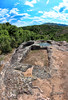
Sanctuaries in 7-meter long, small natural cave. The earliest ceramic fragments date from the late Chalcolithic period and the latest from the 1st and 2nd c. CE. The entrance to the cave could be closed with a door as the threshold and grooves are still recognizable in the rocks. The two terraces hewn in the rocks outside the cave, one being circular, indicated the site had an astonomical purpose.
The remains of the biggest ancient Thracian city which had its flowering between the 6th and 1st cenury BCE lies below this sanctuary.
You may be viewing yesterday's version of this page. To see the most up to date information please register for a free account.
Do not use the above information on other web sites or publications without permission of the contributor.
Nearby Images from Flickr
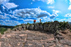
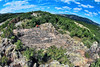
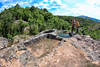
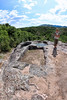

The above images may not be of the site on this page, but were taken nearby. They are loaded from Flickr so please click on them for image credits.
Click here to see more info for this site
Nearby sites
Click here to view sites on an interactive map of the areaKey: Red: member's photo, Blue: 3rd party photo, Yellow: other image, Green: no photo - please go there and take one, Grey: site destroyed
Download sites to:
KML (Google Earth)
GPX (GPS waypoints)
CSV (Garmin/Navman)
CSV (Excel)
To unlock full downloads you need to sign up as a Contributory Member. Otherwise downloads are limited to 50 sites.
Turn off the page maps and other distractions
Nearby sites listing. In the following links * = Image available
4.3km SE 145° Tatul Thracian Temple* Ancient Temple
12.9km NNW 341° Perperikon Tombs Rock Cut Tomb
15.4km ENE 64° Pchelari Rock Cut Tomb Rock Cut Tomb
16.1km NNW 344° Perperikon* Ancient Temple
21.6km SW 230° Ovchevo Rock Cut Tomb Rock Cut Tomb
27.4km ENE 64° Dolni Glavanak Stone Circle* Stone Circle
33.4km SE 138° Chernichevo Dolmen Burial Chamber or Dolmen
34.0km WNW 302° Nenkovo Rock Womb* Cave or Rock Shelter
37.8km ESE 106° Zhelezino Dolmen* Chambered Tomb
43.9km ESE 108° Plevun dolmen Chambered Tomb
45.2km NE 39° Ostur kamuk Dolmen Burial Chamber or Dolmen
49.6km E 91° Oryahovo Dolmen* Chambered Tomb
51.3km SE 124° Dolmen Roussa 3* Burial Chamber or Dolmen
51.3km SE 124° Roussa Dolmen* Burial Chamber or Dolmen
51.8km ENE 70° Mezek Thracian tomb Chambered Tomb
52.2km SE 126° Dolmen Roussa* Burial Chamber or Dolmen
54.8km NW 304° Belintash Ancient Temple
62.9km NE 39° Chuchul Kamak Standing Stone (Menhir)
63.6km NE 49° Mound near Izvorovo* Round Barrow(s)
64.0km NE 55° Eshmedzhika Dolmen Burial Chamber or Dolmen
68.1km SE 132° Dolmen Kotronia 1* Burial Chamber or Dolmen
77.3km S 180° Maroneia* Ancient Village or Settlement
79.4km NE 48° Balgarska Poliana Dolmen* Chambered Tomb
79.7km NE 49° Gaidarov Dolap dolmen Chambered Tomb
84.4km SSW 213° Abdera* Ancient Village or Settlement
View more nearby sites and additional images


 We would like to know more about this location. Please feel free to add a brief description and any relevant information in your own language.
 Wir möchten mehr über diese Stätte erfahren. Bitte zögern Sie nicht, eine kurze Beschreibung und relevante Informationen in Deutsch hinzuzufügen.
 Nous aimerions en savoir encore un peu sur les lieux. S'il vous plaît n'hesitez pas à ajouter une courte description et tous les renseignements pertinents dans votre propre langue.
 Quisieramos informarnos un poco más de las lugares. No dude en añadir una breve descripción y otros datos relevantes en su propio idioma.