

<< Our Photo Pages >> Grodzisko Małpia Wyspa - Hillfort in Poland in Malopolskie
Submitted by SolarMegalith on Monday, 08 September 2014 Page Views: 1539
Iron Age and Later PrehistorySite Name: Grodzisko Małpia WyspaCountry: Poland
NOTE: This site is 8.482 km away from the location you searched for.
Voivodeship: Malopolskie Type: Hillfort
Nearest Town: Nowy Sącz Nearest Village: Gródek nad Dunajcem
Latitude: 49.748531N Longitude: 20.724027E
Condition:
| 5 | Perfect |
| 4 | Almost Perfect |
| 3 | Reasonable but with some damage |
| 2 | Ruined but still recognisable as an ancient site |
| 1 | Pretty much destroyed, possibly visible as crop marks |
| 0 | No data. |
| -1 | Completely destroyed |
| 5 | Superb |
| 4 | Good |
| 3 | Ordinary |
| 2 | Not Good |
| 1 | Awful |
| 0 | No data. |
| 5 | Can be driven to, probably with disabled access |
| 4 | Short walk on a footpath |
| 3 | Requiring a bit more of a walk |
| 2 | A long walk |
| 1 | In the middle of nowhere, a nightmare to find |
| 0 | No data. |
| 5 | co-ordinates taken by GPS or official recorded co-ordinates |
| 4 | co-ordinates scaled from a detailed map |
| 3 | co-ordinates scaled from a bad map |
| 2 | co-ordinates of the nearest village |
| 1 | co-ordinates of the nearest town |
| 0 | no data |
Internal Links:
External Links:
I have visited· I would like to visit
SolarMegalith visited on 25th Aug 2014 - their rating: Access: 2
")
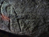
A small early medieval hillfort located on the top of a hill which became an island after creation of the artificial Rożnowskie Lake. The hillfort is called Małpia Wyspa ("Monkey island").
You may be viewing yesterday's version of this page. To see the most up to date information please register for a free account.
")
Do not use the above information on other web sites or publications without permission of the contributor.
Nearby Images from Flickr
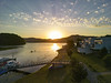
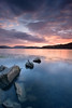
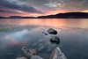
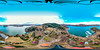
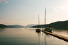
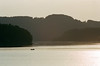
The above images may not be of the site on this page, but were taken nearby. They are loaded from Flickr so please click on them for image credits.
Click here to see more info for this site
Nearby sites
Click here to view sites on an interactive map of the areaKey: Red: member's photo, Blue: 3rd party photo, Yellow: other image, Green: no photo - please go there and take one, Grey: site destroyed
Download sites to:
KML (Google Earth)
GPX (GPS waypoints)
CSV (Garmin/Navman)
CSV (Excel)
To unlock full downloads you need to sign up as a Contributory Member. Otherwise downloads are limited to 50 sites.
Turn off the page maps and other distractions
Nearby sites listing. In the following links * = Image available
9.6km SSW 204° Grodzisko Marcinkowice* Hillfort
12.8km SSW 201° Grodzisko Chełmiec* Hillfort
14.5km NNE 19° Grodzisko Zawada Lanckorońska* Hillfort
15.9km NNE 26° Grodzisko Roztoka* Promontory Fort / Cliff Castle
22.0km SSW 210° Grodzisko Grobla - Podegrodzie* Hillfort
22.4km NNW 346° Grodzisko Jadowniki Podgórne* Hillfort
25.0km SSW 208° Grodzisko Naszacowice* Hillfort
28.5km SW 220° Grodzisko Góra Zyndrama Hillfort
33.0km NE 37° Grodzisko Zawada (Tarnów)* Hillfort
35.5km NW 315° Grodzisko Łapczyca Hillfort
41.3km W 281° Grodzisko Klasztorzysko* Hillfort
41.8km NW 306° Kurhan Krakuszowice Round Barrow(s)
42.2km W 281° Grodzisko Poznachowice Górne* Hillfort
44.8km WNW 300° Kurhany Jawczyce Barrow Cemetery
47.7km ENE 68° Grodzisko Przeczyca* Hillfort
50.8km E 92° Grodzisko Trzcinica* Hillfort
51.0km E 92° Trzcinica - Ekspozycja Archeologiczna* Museum
56.6km N 353° Kurhan Królewice* Round Barrow(s)
57.3km ESE 110° Grodzisko Walik - Brzezowa* Hillfort
59.1km NW 308° Kopiec Wandy* Artificial Mound
60.3km E 86° Kurhany Bierówka* Barrow Cemetery
61.0km N 359° Czarkowy - Kopiec Kościuszki Round Barrow(s)
63.6km WNW 301° Kopiec Krakusa* Artificial Mound
64.9km N 354° Kurhany Kolosy* Round Barrow(s)
65.9km WNW 301° Kraków - Wawel* Ancient Village or Settlement
View more nearby sites and additional images


 We would like to know more about this location. Please feel free to add a brief description and any relevant information in your own language.
 Wir möchten mehr über diese Stätte erfahren. Bitte zögern Sie nicht, eine kurze Beschreibung und relevante Informationen in Deutsch hinzuzufügen.
 Nous aimerions en savoir encore un peu sur les lieux. S'il vous plaît n'hesitez pas à ajouter une courte description et tous les renseignements pertinents dans votre propre langue.
 Quisieramos informarnos un poco más de las lugares. No dude en añadir una breve descripción y otros datos relevantes en su propio idioma.