<< Text Pages >> Nan Madol - Ancient Temple in Pacific Islands
Submitted by KaiHofmann on Monday, 15 April 2013 Page Views: 6224
Multi-periodSite Name: Nan MadolCountry: Pacific Islands
NOTE: This site is 18.379 km away from the location you searched for.
Type: Ancient Temple
Nearest Town: Palikir Nearest Village: Tamworohi
Latitude: 6.845181N Longitude: 158.333439E
Condition:
| 5 | Perfect |
| 4 | Almost Perfect |
| 3 | Reasonable but with some damage |
| 2 | Ruined but still recognisable as an ancient site |
| 1 | Pretty much destroyed, possibly visible as crop marks |
| 0 | No data. |
| -1 | Completely destroyed |
| 5 | Superb |
| 4 | Good |
| 3 | Ordinary |
| 2 | Not Good |
| 1 | Awful |
| 0 | No data. |
| 5 | Can be driven to, probably with disabled access |
| 4 | Short walk on a footpath |
| 3 | Requiring a bit more of a walk |
| 2 | A long walk |
| 1 | In the middle of nowhere, a nightmare to find |
| 0 | No data. |
| 5 | co-ordinates taken by GPS or official recorded co-ordinates |
| 4 | co-ordinates scaled from a detailed map |
| 3 | co-ordinates scaled from a bad map |
| 2 | co-ordinates of the nearest village |
| 1 | co-ordinates of the nearest town |
| 0 | no data |
Internal Links:
External Links:
Ancient Temple in Pacific Islands
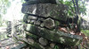
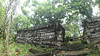
Huge megalithic complex of artificial stone islands. The main island temple-platform (Marae) is called Nan Douwas. The platforms were built with natural basalt stone blocks.
You may be viewing yesterday's version of this page. To see the most up to date information please register for a free account.
Do not use the above information on other web sites or publications without permission of the contributor.
Nearby Images from Flickr
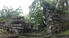
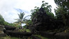
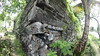
The above images may not be of the site on this page, but were taken nearby. They are loaded from Flickr so please click on them for image credits.
Click here to see more info for this site
Nearby sites
Click here to view sites on an interactive map of the areaKey: Red: member's photo, Blue: 3rd party photo, Yellow: other image, Green: no photo - please go there and take one, Grey: site destroyed
Download sites to:
KML (Google Earth)
GPX (GPS waypoints)
CSV (Garmin/Navman)
CSV (Excel)
To unlock full downloads you need to sign up as a Contributory Member. Otherwise downloads are limited to 50 sites.
Turn off the page maps and other distractions
Nearby sites listing. In the following links * = Image available
1654.8km NW 304° House of Taga* Sculptured Stone
1655.8km WNW 298° Fafai Beach Standing Stones
1877.6km SSW 205° O'utuyam* Burial Chamber or Dolmen
2243.7km WSW 243° Tutari megalithic site* Standing Stones
2250.0km W 279° Rai Row Yap Stone Row / Alignment
2471.0km SSE 156° Tamate stone engravings Rock Art
2715.0km SSE 159° Norohure & Togh-Vanu Sculptured Stone
2718.5km SSE 159° Yalo Cave & Apialo Cave Rock Art
2720.3km SSE 159° Tolamp Standing Stone (Menhir)
2928.0km SSE 158° Feles Cave rock art Rock Art
2928.6km SSW 211° Spilt Rock Park Rock Art Rock Art
2956.9km WSW 247° Bitsyari Bay, West Papua* Rock Art
2957.3km SSE 158° Teouma Ancient Cemetery Barrow Cemetery
3075.5km SSE 158° Velemendi cave Rock Art
3112.4km SSE 158° Potnangai cave Petroglyphs Rock Art
3170.5km SSW 208° Kinara Volcano Natural Stone / Erratic / Other Natural Feature
3253.5km SSE 157° Aname petroglyphs Rock Art
3338.8km SSE 165° Paita Valley Petroglyphs* Rock Art
3436.2km SW 232° Nawarla Gabarnmung rock art site Rock Art
3466.8km SE 141° Nakauvadra Standing Stones and Narara Caves Standing Stones
3528.6km SW 233° Kakadu - Ubirr* Rock Art
3540.1km SW 233° Kakadu - Madjedbebe* Cave or Rock Shelter
3615.1km SW 232° Kakadu* Rock Art
3653.7km NNW 331° Higashiyama Yokoana* Rock Cut Tomb
3671.4km NNW 332° Enchō-ji temple* Standing Stone (Menhir)
View more nearby sites and additional images


 We would like to know more about this location. Please feel free to add a brief description and any relevant information in your own language.
 Wir möchten mehr über diese Stätte erfahren. Bitte zögern Sie nicht, eine kurze Beschreibung und relevante Informationen in Deutsch hinzuzufügen.
 Nous aimerions en savoir encore un peu sur les lieux. S'il vous plaît n'hesitez pas à ajouter une courte description et tous les renseignements pertinents dans votre propre langue.
 Quisieramos informarnos un poco más de las lugares. No dude en añadir una breve descripción y otros datos relevantes en su propio idioma.