


<< Other Photo Pages >> Kakadu - Madjedbebe - Cave or Rock Shelter in Australia
Submitted by bat400 on Friday, 28 July 2017 Page Views: 3242
Natural PlacesSite Name: Kakadu - Madjedbebe Alternative Name: Malagananja IICountry: Australia Type: Cave or Rock Shelter
Nearest Town: Darwin, NT Nearest Village: Jabiru, NT
Latitude: 12.52S Longitude: 132.910000E
Condition:
| 5 | Perfect |
| 4 | Almost Perfect |
| 3 | Reasonable but with some damage |
| 2 | Ruined but still recognisable as an ancient site |
| 1 | Pretty much destroyed, possibly visible as crop marks |
| 0 | No data. |
| -1 | Completely destroyed |
| 5 | Superb |
| 4 | Good |
| 3 | Ordinary |
| 2 | Not Good |
| 1 | Awful |
| 0 | No data. |
| 5 | Can be driven to, probably with disabled access |
| 4 | Short walk on a footpath |
| 3 | Requiring a bit more of a walk |
| 2 | A long walk |
| 1 | In the middle of nowhere, a nightmare to find |
| 0 | No data. |
| 5 | co-ordinates taken by GPS or official recorded co-ordinates |
| 4 | co-ordinates scaled from a detailed map |
| 3 | co-ordinates scaled from a bad map |
| 2 | co-ordinates of the nearest village |
| 1 | co-ordinates of the nearest town |
| 0 | no data |
Be the first person to rate this site - see the 'Contribute!' box in the right hand menu.
Internal Links:
External Links:
")
At this rock shelter beneath a sandstone massif, excavations dating back to the 1970s established it as one of the oldest human habitation sites in Australia. Recent excavations approved through the Gundjeihmi Aboriginal Corporation have pushed this occupation period to 65000 years through Optically Stimulated Luminescence (OSL) analysis.
"It contains examples of early artistic activities and possibly the oldest evidence of grindstone and hatchet technology in the country. The site is significant to the Mirarr people as an important historic camping place between Jabiru and Gunbalanya (Oenpelli)." - taken from "The Mirarr."
The site is within the Jabiru Mineral Lease area, within the borders of the Kakadu National Park. The location given is general for this area and does not reflect the exact location of Madjedbebe.
Sources:
[Cached] : "The Mirarr", Cached at http://www.mirarr.net/...
Note: Humans in Australia 65,000 years ago. See comments.
You may be viewing yesterday's version of this page. To see the most up to date information please register for a free account.
")
Do not use the above information on other web sites or publications without permission of the contributor.
Nearby Images from Flickr
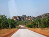
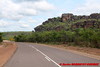
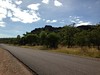
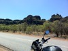

The above images may not be of the site on this page, but were taken nearby. They are loaded from Flickr so please click on them for image credits.
Click here to see more info for this site
Nearby sites
Click here to view sites on an interactive map of the areaKey: Red: member's photo, Blue: 3rd party photo, Yellow: other image, Green: no photo - please go there and take one, Grey: site destroyed
Download sites to:
KML (Google Earth)
GPX (GPS waypoints)
CSV (Garmin/Navman)
CSV (Excel)
To unlock full downloads you need to sign up as a Contributory Member. Otherwise downloads are limited to 50 sites.
Turn off the page maps and other distractions
Nearby sites listing. In the following links * = Image available
13.4km NNE 23° Kakadu - Ubirr* Rock Art
76.7km SW 222° Kakadu* Rock Art
107.7km ENE 69° Nawarla Gabarnmung rock art site Rock Art
707.3km WSW 253° Kalumburu Cave or Rock Shelter
724.4km WSW 245° Drysdale River National Park Rock Art
769.9km NW 306° Jerimalai Cave or Rock Shelter
906.4km S 171° Devil's Marbles* Natural Stone / Erratic / Other Natural Feature
920.0km SW 216° Wolf Creek Crater Natural Stone / Erratic / Other Natural Feature
973.8km N 7° Bitsyari Bay, West Papua* Rock Art
1298.0km ESE 107° Spilt Rock Park Rock Art Rock Art
1340.4km S 179° Henbury Meteorite Craters* Natural Stone / Erratic / Other Natural Feature
1364.1km WNW 286° Bena Village Megaliths* Ancient Village or Settlement
1383.6km NE 37° Tutari megalithic site* Standing Stones
1388.0km WNW 282° Rindi Umalulu Burial Chamber or Dolmen
1433.0km WNW 287° Liang Bua Cave Cave or Rock Shelter
1439.6km S 188° Ayers Rock* Rock Art
1441.0km ESE 118° Kinara Volcano Natural Stone / Erratic / Other Natural Feature
1491.2km WNW 281° Anakalang Burial Chamber or Dolmen
1505.1km W 281° Waikabubak East Burial Chamber or Dolmen
1507.8km W 281° Waikabubak Burial Chamber or Dolmen
1677.8km WNW 299° Leang Leang Rock Art
1691.7km WNW 298° Maros (Sulawesi) Rock Art
1779.5km NW 305° Londa Tana Toraja Rock Cut Tomb
1779.9km NW 305° Ke´te Kesu´ Standing Stones* Stone Circle
1784.1km NW 306° Batu-Batu Standing Stones Standing Stones
View more nearby sites and additional images


 We would like to know more about this location. Please feel free to add a brief description and any relevant information in your own language.
 Wir möchten mehr über diese Stätte erfahren. Bitte zögern Sie nicht, eine kurze Beschreibung und relevante Informationen in Deutsch hinzuzufügen.
 Nous aimerions en savoir encore un peu sur les lieux. S'il vous plaît n'hesitez pas à ajouter une courte description et tous les renseignements pertinents dans votre propre langue.
 Quisieramos informarnos un poco más de las lugares. No dude en añadir una breve descripción y otros datos relevantes en su propio idioma.