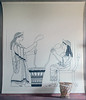
<< Other Photo Pages >> Foce del Sele Temple of Hera - Ancient Temple in Italy in Calabria
Submitted by AlexHunger on Sunday, 09 September 2007 Page Views: 7201
Roman, Greek and ClassicalSite Name: Foce del Sele Temple of Hera Alternative Name: HeraionCountry: Italy
NOTE: This site is 45.857 km away from the location you searched for.
Region: Calabria Type: Ancient Temple
Nearest Town: Napoli Nearest Village: Paestum
Latitude: 40.488452N Longitude: 14.969493E
Condition:
| 5 | Perfect |
| 4 | Almost Perfect |
| 3 | Reasonable but with some damage |
| 2 | Ruined but still recognisable as an ancient site |
| 1 | Pretty much destroyed, possibly visible as crop marks |
| 0 | No data. |
| -1 | Completely destroyed |
| 5 | Superb |
| 4 | Good |
| 3 | Ordinary |
| 2 | Not Good |
| 1 | Awful |
| 0 | No data. |
| 5 | Can be driven to, probably with disabled access |
| 4 | Short walk on a footpath |
| 3 | Requiring a bit more of a walk |
| 2 | A long walk |
| 1 | In the middle of nowhere, a nightmare to find |
| 0 | No data. |
| 5 | co-ordinates taken by GPS or official recorded co-ordinates |
| 4 | co-ordinates scaled from a detailed map |
| 3 | co-ordinates scaled from a bad map |
| 2 | co-ordinates of the nearest village |
| 1 | co-ordinates of the nearest town |
| 0 | no data |
Internal Links:
External Links:
Ancient Temple in Campania
Foundations of ancient Greek Doric temple whose construction was begun around 500 BCE. It measures 19 metres by 39 metres and has 8 by 17 columns.
The temple was damaged by fire around 400 to 350 BCE and then restored. The sanctuary survived until the 2nd Century BCE.
There is a museum nearby.
More information at the Perseus Project.
You may be viewing yesterday's version of this page. To see the most up to date information please register for a free account.
Do not use the above information on other web sites or publications without permission of the contributor.
davidmorgan has found this location on Google Street View:
Nearby Images from Flickr


The above images may not be of the site on this page, but were taken nearby. They are loaded from Flickr so please click on them for image credits.
Click here to see more info for this site
Nearby sites
Click here to view sites on an interactive map of the areaKey: Red: member's photo, Blue: 3rd party photo, Yellow: other image, Green: no photo - please go there and take one, Grey: site destroyed
Download sites to:
KML (Google Earth)
GPX (GPS waypoints)
CSV (Garmin/Navman)
CSV (Excel)
To unlock full downloads you need to sign up as a Contributory Member. Otherwise downloads are limited to 50 sites.
Turn off the page maps and other distractions
Nearby sites listing. In the following links * = Image available
7.7km SSE 157° Poseidonia Temple of Athena* Ancient Temple
8.2km SSE 158° Poseidonia Temple of Poseidon* Ancient Temple
8.3km SSE 158° Poseidonia Temple of Hera* Ancient Temple
39.7km SSE 157° Eleia Temple Ancient Temple
50.2km NW 306° Macellum of Pompeii* Modern Stone Circle etc
50.5km NW 305° Pompeii* Ancient Village or Settlement
63.3km NW 304° Herculaneum Ancient Village or Settlement
103.8km SE 128° Grotta del Romito Cave or Rock Shelter
116.4km NW 309° Roccia San Sebastiano Cave or Rock Shelter
125.1km NNE 24° Daunian Arpi Ancient Village or Settlement
130.1km NNE 24° Passo di Corvo* Henge
133.5km NE 48° Canne Standing Stone* Standing Stone (Menhir)
134.0km NE 47° Mount of Cannae* Ancient Village or Settlement
139.2km ENE 73° Altamura Mura Megalitiche* Stone Fort or Dun
140.1km E 81° Matera* Cave or Rock Shelter
140.4km NNE 22° Dolmen di Madonna di Cristo Burial Chamber or Dolmen
140.4km NNE 22° Grotta Paglicci Cave or Rock Shelter
141.8km NNE 21° Museo Grotta Paglicci e il Paliolitico del Gargano Museum
142.0km ENE 71° La grotta di Lamalunga Cave or Rock Shelter
144.2km ENE 64° Pietrefitte 10 Standing Stone (Menhir)
145.8km ENE 64° Pietrefitte 9 Standing Stone (Menhir)
145.9km ESE 105° Cugno dei Vagni* Ancient Village or Settlement
146.0km ENE 64° Pietrefitte 8 Standing Stone (Menhir)
146.0km NNE 31° Ipogei Capparelli Ancient Village or Settlement
146.5km ENE 58° Paladini Dolmen* Burial Chamber or Dolmen
View more nearby sites and additional images


 We would like to know more about this location. Please feel free to add a brief description and any relevant information in your own language.
 Wir möchten mehr über diese Stätte erfahren. Bitte zögern Sie nicht, eine kurze Beschreibung und relevante Informationen in Deutsch hinzuzufügen.
 Nous aimerions en savoir encore un peu sur les lieux. S'il vous plaît n'hesitez pas à ajouter une courte description et tous les renseignements pertinents dans votre propre langue.
 Quisieramos informarnos un poco más de las lugares. No dude en añadir una breve descripción y otros datos relevantes en su propio idioma.