<< Our Photo Pages >> Tutari megalithic site - Standing Stones in Indonesia
Submitted by geo-org on Monday, 25 November 2019 Page Views: 1609
Neolithic and Bronze AgeSite Name: Tutari megalithic siteCountry: Indonesia
NOTE: This site is 383.735 km away from the location you searched for.
Type: Standing Stones
Nearest Town: Jayapura Nearest Village: Doyo Lama
Latitude: 2.56864S Longitude: 140.453840E
Condition:
| 5 | Perfect |
| 4 | Almost Perfect |
| 3 | Reasonable but with some damage |
| 2 | Ruined but still recognisable as an ancient site |
| 1 | Pretty much destroyed, possibly visible as crop marks |
| 0 | No data. |
| -1 | Completely destroyed |
| 5 | Superb |
| 4 | Good |
| 3 | Ordinary |
| 2 | Not Good |
| 1 | Awful |
| 0 | No data. |
| 5 | Can be driven to, probably with disabled access |
| 4 | Short walk on a footpath |
| 3 | Requiring a bit more of a walk |
| 2 | A long walk |
| 1 | In the middle of nowhere, a nightmare to find |
| 0 | No data. |
| 5 | co-ordinates taken by GPS or official recorded co-ordinates |
| 4 | co-ordinates scaled from a detailed map |
| 3 | co-ordinates scaled from a bad map |
| 2 | co-ordinates of the nearest village |
| 1 | co-ordinates of the nearest town |
| 0 | no data |
Internal Links:
External Links:
")
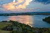
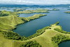
The Tutari megalithic site is located in close proximity of the Sentani lake in the village Doyo Lama just 20 minutes away from the Sentani Airport Jayapura, Papua province, Indonesia.
You enter the site through a small gate in a property at the entrance of the village. You walk up a cemented path leading up to a hill full of dark boulders and rocks of all sizes and shapes. The dry and hilly area has been reforested with Melaleuca trees (Kayu putih). The authorities have made some attempts to preserve the site and make it accessible. There are some roofs protecting some of the special features along with benches, fences and pathways. There are however no explanations or clear signs, so it takes some time to find the engravings. From internet research there are indications that the site is Neolithic. You find engravings of turtles, fishes, biawaks along with curious rock formations reminding of animals that might have been worshiped.
A special curious engraving is a natural light-coloured vein within a dark rock which was decorated with circles (See picture)
The overall site is several hectares big and offers a magnificent view on the Sentani lake. You could spent hours exploring and looking for engravings.
The best additional information is provided by the Mongabay web site(in Bahasa Indonesia, however with an embedded YouTube video with a good overview). There has been scientific research done as well by a team of french archaeologists:
GIRARD Coralie - Prospection d’un site d’art rupestre longtemps oublié en Nouvelle-Guinée, site de Tutari (Doyo Lama, Jayapura, Province de Papouasie, Indonésie) - Tuteurs : M. Vanhaeren, W. Schiefenhövel et G. M. Sudarmika.
You may be viewing yesterday's version of this page. To see the most up to date information please register for a free account.
")
")
")
Do not use the above information on other web sites or publications without permission of the contributor.
Nearby Images from Flickr


The above images may not be of the site on this page, but were taken nearby. They are loaded from Flickr so please click on them for image credits.
Click here to see more info for this site
Nearby sites
Click here to view sites on an interactive map of the areaKey: Red: member's photo, Blue: 3rd party photo, Yellow: other image, Green: no photo - please go there and take one, Grey: site destroyed
Download sites to:
KML (Google Earth)
GPX (GPS waypoints)
CSV (Garmin/Navman)
CSV (Excel)
To unlock full downloads you need to sign up as a Contributory Member. Otherwise downloads are limited to 50 sites.
Turn off the page maps and other distractions
Nearby sites listing. In the following links * = Image available
737.4km W 259° Bitsyari Bay, West Papua* Rock Art
1292.8km SW 214° Nawarla Gabarnmung rock art site Rock Art
1348.1km ESE 119° O'utuyam* Burial Chamber or Dolmen
1362.3km N 349° Rai Row Yap Stone Row / Alignment
1370.6km SW 217° Kakadu - Ubirr* Rock Art
1383.6km SW 217° Kakadu - Madjedbebe* Cave or Rock Shelter
1460.1km SW 217° Kakadu* Rock Art
1520.9km SSE 163° Spilt Rock Park Rock Art Rock Art
1598.3km WSW 246° Jerimalai Cave or Rock Shelter
1825.9km SSE 165° Kinara Volcano Natural Stone / Erratic / Other Natural Feature
1852.5km NNE 15° Fafai Beach Standing Stones
1998.9km SW 229° Kalumburu Cave or Rock Shelter
2031.3km NNE 16° House of Taga* Sculptured Stone
2051.6km SW 226° Drysdale River National Park Rock Art
2111.1km SSW 198° Devil's Marbles* Natural Stone / Erratic / Other Natural Feature
2232.0km W 273° Situs Pekasele* Sculptured Stone
2243.7km ENE 62° Nan Madol Ancient Temple
2249.5km W 272° Bada Valley Megaliths* Sculptured Stone
2264.2km WSW 251° Bena Village Megaliths* Ancient Village or Settlement
2280.9km W 269° Bori Kalimbuang* Stone Circle
2281.0km W 269° Batu-Batu Standing Stones Standing Stones
2282.2km W 268° Ke´te Kesu´ Standing Stones* Stone Circle
2283.9km W 268° Londa Tana Toraja Rock Cut Tomb
2303.3km SW 216° Wolf Creek Crater Natural Stone / Erratic / Other Natural Feature
2308.3km W 268° Pali Standing Stones* Standing Stones
View more nearby sites and additional images


 We would like to know more about this location. Please feel free to add a brief description and any relevant information in your own language.
 Wir möchten mehr über diese Stätte erfahren. Bitte zögern Sie nicht, eine kurze Beschreibung und relevante Informationen in Deutsch hinzuzufügen.
 Nous aimerions en savoir encore un peu sur les lieux. S'il vous plaît n'hesitez pas à ajouter une courte description et tous les renseignements pertinents dans votre propre langue.
 Quisieramos informarnos un poco más de las lugares. No dude en añadir una breve descripción y otros datos relevantes en su propio idioma.