


<< Our Photo Pages >> Lechův Kámen - Rock Outcrop in Czech Republic in Bohemia
Submitted by ladrin on Monday, 28 May 2018 Page Views: 923
Natural PlacesSite Name: Lechův Kámen Alternative Name: Lech's stoneCountry: Czech Republic
NOTE: This site is 9.386 km away from the location you searched for.
Region: Bohemia Type: Rock Outcrop
Nearest Town: Kouřim
Latitude: 50.002259N Longitude: 14.986255E
Condition:
| 5 | Perfect |
| 4 | Almost Perfect |
| 3 | Reasonable but with some damage |
| 2 | Ruined but still recognisable as an ancient site |
| 1 | Pretty much destroyed, possibly visible as crop marks |
| 0 | No data. |
| -1 | Completely destroyed |
| 5 | Superb |
| 4 | Good |
| 3 | Ordinary |
| 2 | Not Good |
| 1 | Awful |
| 0 | No data. |
| 5 | Can be driven to, probably with disabled access |
| 4 | Short walk on a footpath |
| 3 | Requiring a bit more of a walk |
| 2 | A long walk |
| 1 | In the middle of nowhere, a nightmare to find |
| 0 | No data. |
| 5 | co-ordinates taken by GPS or official recorded co-ordinates |
| 4 | co-ordinates scaled from a detailed map |
| 3 | co-ordinates scaled from a bad map |
| 2 | co-ordinates of the nearest village |
| 1 | co-ordinates of the nearest town |
| 0 | no data |
Internal Links:
External Links:
")
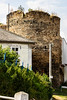
But from older sources is known simply as a Great stone. According local tradition the stone was important place of ancient pagan rituals and also later in the Middle age witches were burned here allegedly. The true is that the rock is located just a several tens of meters from the rampart of the large prehistoric hillfort of old Slavs.
And another interesting fact is that about 300m SE from here can be found the intersection of the 50. parallel and the 15. meridian.
You may be viewing yesterday's version of this page. To see the most up to date information please register for a free account.
")
")
")
")
Do not use the above information on other web sites or publications without permission of the contributor.
Nearby Images from Flickr

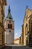
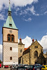

The above images may not be of the site on this page, but were taken nearby. They are loaded from Flickr so please click on them for image credits.
Click here to see more info for this site
Nearby sites
Click here to view sites on an interactive map of the areaKey: Red: member's photo, Blue: 3rd party photo, Yellow: other image, Green: no photo - please go there and take one, Grey: site destroyed
Download sites to:
KML (Google Earth)
GPX (GPS waypoints)
CSV (Garmin/Navman)
CSV (Excel)
To unlock full downloads you need to sign up as a Contributory Member. Otherwise downloads are limited to 50 sites.
Turn off the page maps and other distractions
Nearby sites listing. In the following links * = Image available
380m SE 128° Stará Kouřim* Hillfort
7.3km NNW 347° Mohyla Chotouň* Artificial Mound
14.5km SSW 204° Devil's Groove* Misc. Earthwork
15.5km SSW 192° Stone Man* Standing Stone (Menhir)
15.8km E 81° Rondel Enclosures near Kolin Causewayed Enclosure
15.9km ESE 115° Hill of Vysoka Modern Stone Circle etc
16.4km SSW 205° Well of St.Procopius* Holy Well or Sacred Spring
18.7km NNW 346° Hradištko Menhir* Standing Stone (Menhir)
18.7km ESE 110° Wellspring of St. Vojtech* Standing Stone (Menhir)
18.7km ESE 110° Spring of St. Vojtech* Holy Well or Sacred Spring
19.5km E 95° Libenice Menhir* Modern Stone Circle etc
19.6km ESE 112° Bylany Neolithic Settlement* Ancient Village or Settlement
19.7km E 94° Libenice Shrine* Ancient Temple
20.2km ESE 113° Bylany stone row* Stone Row / Alignment
20.6km WNW 295° Úvaly Stonehenge* Modern Stone Circle etc
20.7km NNW 330° Přerovská Hůra* Hillfort
20.7km W 277° Prehistoric hillfort Březí* Hillfort
20.8km ESE 103° Kutna Hora's stone circle* Modern Stone Circle etc
20.8km ESE 103° Kutná Hora Megaliths* Modern Stone Circle etc
20.9km NNE 11° Prehistoric Barrow Nymburk* Chambered Cairn
21.4km E 99° Bába (The Hag)* Ancient Cross
21.5km E 99° Kaňk Menhir* Modern Stone Circle etc
33.3km WNW 298° Vinoř Rondel* Causewayed Enclosure
35.0km WSW 248° Dolmen na Kněží Hoře* Modern Stone Circle etc
35.2km WSW 248° Kněží Hora* Standing Stones
View more nearby sites and additional images


 We would like to know more about this location. Please feel free to add a brief description and any relevant information in your own language.
 Wir möchten mehr über diese Stätte erfahren. Bitte zögern Sie nicht, eine kurze Beschreibung und relevante Informationen in Deutsch hinzuzufügen.
 Nous aimerions en savoir encore un peu sur les lieux. S'il vous plaît n'hesitez pas à ajouter une courte description et tous les renseignements pertinents dans votre propre langue.
 Quisieramos informarnos un poco más de las lugares. No dude en añadir una breve descripción y otros datos relevantes en su propio idioma.