


<< Our Photo Pages >> Fykan Carvings - Carving in Norway in Nordland
Submitted by kenntha88 on Saturday, 31 October 2009 Page Views: 2612
Multi-periodSite Name: Fykan CarvingsCountry: Norway Fylke: Nordland Type: Carving
Nearest Town: Bodø Nearest Village: Glomfjord
Latitude: 66.793625N Longitude: 14.009113E
Condition:
| 5 | Perfect |
| 4 | Almost Perfect |
| 3 | Reasonable but with some damage |
| 2 | Ruined but still recognisable as an ancient site |
| 1 | Pretty much destroyed, possibly visible as crop marks |
| 0 | No data. |
| -1 | Completely destroyed |
| 5 | Superb |
| 4 | Good |
| 3 | Ordinary |
| 2 | Not Good |
| 1 | Awful |
| 0 | No data. |
| 5 | Can be driven to, probably with disabled access |
| 4 | Short walk on a footpath |
| 3 | Requiring a bit more of a walk |
| 2 | A long walk |
| 1 | In the middle of nowhere, a nightmare to find |
| 0 | No data. |
| 5 | co-ordinates taken by GPS or official recorded co-ordinates |
| 4 | co-ordinates scaled from a detailed map |
| 3 | co-ordinates scaled from a bad map |
| 2 | co-ordinates of the nearest village |
| 1 | co-ordinates of the nearest town |
| 0 | no data |
Internal Links:
External Links:
I have visited· I would like to visit
Martin_L has visited here
")
The site contains several figures of reindeer and elk. The site have been well documented in literature. When I visited the place, only parts of a reindeer figure without the head was visible.
The carvings are actually not carved, but "ground" into the rock, producing white stripes on the rock surface and they do not go very deep into the rock. Similar technique is known from sites like Leikneset and Sagelv.
They are believed to be dating back to the older stone age, about 5000 to 7000 BC. This make them very old in rock art history.
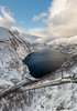
The site itself lies in a beautiful landscape overlooking the Glomfjord and the steep mountainsides surrounding the valley. There is also a lake to the east, and a small river goes from the lake to the sea. It is a beautiful view from this place and that itself makes it well worth a visit.
You may be viewing yesterday's version of this page. To see the most up to date information please register for a free account.
")
Do not use the above information on other web sites or publications without permission of the contributor.
Nearby Images from Flickr

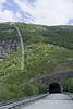
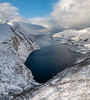
The above images may not be of the site on this page, but were taken nearby. They are loaded from Flickr so please click on them for image credits.
Click here to see more info for this site
Nearby sites
Click here to view sites on an interactive map of the areaKey: Red: member's photo, Blue: 3rd party photo, Yellow: other image, Green: no photo - please go there and take one, Grey: site destroyed
Download sites to:
KML (Google Earth)
GPX (GPS waypoints)
CSV (Garmin/Navman)
CSV (Excel)
To unlock full downloads you need to sign up as a Contributory Member. Otherwise downloads are limited to 50 sites.
Turn off the page maps and other distractions
Nearby sites listing. In the following links * = Image available
13.5km WNW 294° Eidbukta Cemetery* Barrow Cemetery
22.3km W 270° Nedre Vall Standing Stone* Standing Stone (Menhir)
23.1km NW 311° Dalen Gravfelt* Standing Stone (Menhir)
24.5km W 266° Åmøy Carvings* Carving
45.4km NNE 31° Øvre Kvikstad* Standing Stone (Menhir)
53.8km NNE 29° Tuv Storåsen* Standing Stones
55.9km NNE 29° Saltstraumen* Barrow Cemetery
56.7km NNE 16° Nordland Museum, Bodø* Museum
56.9km NNE 17° Bodø Standing Stone* Standing Stone (Menhir)
58.1km NNE 19° Vågøynes monument* Standing Stones
58.7km NNE 18° Opplia* Standing Stone (Menhir)
59.9km NNE 25° Fenes* Standing Stone (Menhir)
61.0km NNE 30° Godøynes* Barrow Cemetery
63.3km NE 40° Kvistadvika settlement* Ancient Village or Settlement
63.6km ESE 113° Stødi sacrificial site* Natural Stone / Erratic / Other Natural Feature
65.7km NE 41° Ljønes burial site* Barrow Cemetery
70.5km NE 37° Mjønes burial site* Barrow Cemetery
77.6km NE 51° Leivset sacrificial site* Natural Stone / Erratic / Other Natural Feature
93.7km SW 222° Gleinsneset Cemetery* Barrow Cemetery
94.1km SW 222° Valhaugen* Round Barrow(s)
102.2km NE 41° Daumannvikflåget* Natural Stone / Erratic / Other Natural Feature
124.5km SW 216° Alstahaug Mound* Round Barrow(s)
128.2km SW 214° Lækkenga Settlement* Ancient Village or Settlement
128.3km NE 37° Mørsvikbotn sacrificial site* Natural Stone / Erratic / Other Natural Feature
128.8km SW 215° Gullhaugen Cemetery* Barrow Cemetery
View more nearby sites and additional images


 We would like to know more about this location. Please feel free to add a brief description and any relevant information in your own language.
 Wir möchten mehr über diese Stätte erfahren. Bitte zögern Sie nicht, eine kurze Beschreibung und relevante Informationen in Deutsch hinzuzufügen.
 Nous aimerions en savoir encore un peu sur les lieux. S'il vous plaît n'hesitez pas à ajouter une courte description et tous les renseignements pertinents dans votre propre langue.
 Quisieramos informarnos un poco más de las lugares. No dude en añadir una breve descripción y otros datos relevantes en su propio idioma.