<< Our Photo Pages >> Takio Hyakketsu - Rock Cut Tomb in Japan in Kyūshū
Submitted by Aska on Saturday, 29 November 2008 Page Views: 3942
Iron Age and Later PrehistorySite Name: Takio Hyakketsu Alternative Name: 滝尾百穴Country: Japan
NOTE: This site is 3.158 km away from the location you searched for.
Region: Kyūshū Type: Rock Cut Tomb
Nearest Town: Ōita (Ōita pref.) Nearest Village: Hada 羽田
Latitude: 33.216110N Longitude: 131.634030E
Condition:
| 5 | Perfect |
| 4 | Almost Perfect |
| 3 | Reasonable but with some damage |
| 2 | Ruined but still recognisable as an ancient site |
| 1 | Pretty much destroyed, possibly visible as crop marks |
| 0 | No data. |
| -1 | Completely destroyed |
| 5 | Superb |
| 4 | Good |
| 3 | Ordinary |
| 2 | Not Good |
| 1 | Awful |
| 0 | No data. |
| 5 | Can be driven to, probably with disabled access |
| 4 | Short walk on a footpath |
| 3 | Requiring a bit more of a walk |
| 2 | A long walk |
| 1 | In the middle of nowhere, a nightmare to find |
| 0 | No data. |
| 5 | co-ordinates taken by GPS or official recorded co-ordinates |
| 4 | co-ordinates scaled from a detailed map |
| 3 | co-ordinates scaled from a bad map |
| 2 | co-ordinates of the nearest village |
| 1 | co-ordinates of the nearest town |
| 0 | no data |
Internal Links:
External Links:
")
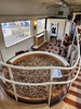
84 rock cut tombs facing the playground of Takio Junior High School (滝尾中学校). Some of tombs may have swallowed footballs kicked by pupils.
You may be viewing yesterday's version of this page. To see the most up to date information please register for a free account.
Do not use the above information on other web sites or publications without permission of the contributor.
Nearby Images from Flickr


The above images may not be of the site on this page, but were taken nearby. They are loaded from Flickr so please click on them for image credits.
Click here to see more info for this site
Nearby sites
Click here to view sites on an interactive map of the areaKey: Red: member's photo, Blue: 3rd party photo, Yellow: other image, Green: no photo - please go there and take one, Grey: site destroyed
Download sites to:
KML (Google Earth)
GPX (GPS waypoints)
CSV (Garmin/Navman)
CSV (Excel)
To unlock full downloads you need to sign up as a Contributory Member. Otherwise downloads are limited to 50 sites.
Turn off the page maps and other distractions
Nearby sites listing. In the following links * = Image available
16.3km ESE 120° Usuzuka Kofun* Sculptured Stone
17.4km ESE 122° Shimoyama Kofun* Sculptured Stone
22.3km N 357° Ōhara Family residence garden* Modern Stone Circle etc
23.4km WNW 296° Tsukumozuka* Artificial Mound
24.2km NNW 341° Fujiwara ōishi* Burial Chamber or Dolmen
29.3km NNW 328° Shimoyama* Stone Circle
33.0km NW 321° Hakusan Jinja shrine* Stone Circle
34.8km SW 219° Hekiun-ji temple* Modern Stone Circle etc
34.9km NW 320° Sada-no-Kyōishi* Standing Stones
35.0km NW 321° Komekami-yama* Stone Circle
35.6km NW 321° Koshiki-iwa* Standing Stone (Menhir)
35.6km SW 219° Okyaku Yashiki* Modern Stone Circle etc
36.3km NW 314° Sanmyō Jinja shrine* Standing Stones
36.5km NW 314° Shimoichi Hyakketsu* Rock Cut Tomb
40.8km NNW 338° Anase Yokoana* Rock Cut Tomb
41.1km NNW 332° Kibune Jinja shrine (in Ōita)* Standing Stones
42.1km N 4° JindaiMoji-iwa* Carving
45.2km NW 320° Yokkaichi Yokoana* Rock Cut Tomb
45.5km WNW 282° Kurushima Family Residence garden* Modern Stone Circle etc
47.5km NNW 347° Kisaki-no-Yamanokami* Standing Stone (Menhir)
47.7km N 353° Kiko Resseki* Stone Circle
48.4km NNW 344° Myōkensha shrine* Stone Circle
58.8km NW 312° Tōbaru* Hillfort
66.3km W 279° Jingabaru* Sculptured Stone
70.7km S 178° Nobeoka Castle* Modern Stone Circle etc
View more nearby sites and additional images


 We would like to know more about this location. Please feel free to add a brief description and any relevant information in your own language.
 Wir möchten mehr über diese Stätte erfahren. Bitte zögern Sie nicht, eine kurze Beschreibung und relevante Informationen in Deutsch hinzuzufügen.
 Nous aimerions en savoir encore un peu sur les lieux. S'il vous plaît n'hesitez pas à ajouter une courte description et tous les renseignements pertinents dans votre propre langue.
 Quisieramos informarnos un poco más de las lugares. No dude en añadir una breve descripción y otros datos relevantes en su propio idioma.