

<< Our Photo Pages >> Bitsyari Bay, West Papua - Rock Art in Indonesia
Submitted by geo-org on Sunday, 17 February 2019 Page Views: 3282
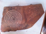
Rock ArtSite Name: Bitsyari Bay, West Papua Alternative Name: Namatote BayCountry: Indonesia Type: Rock Art
Nearest Town: Kaimana Nearest Village: MaiMai
Latitude: 3.82092S Longitude: 133.931240E
Condition:
| 5 | Perfect |
| 4 | Almost Perfect |
| 3 | Reasonable but with some damage |
| 2 | Ruined but still recognisable as an ancient site |
| 1 | Pretty much destroyed, possibly visible as crop marks |
| 0 | No data. |
| -1 | Completely destroyed |
| 5 | Superb |
| 4 | Good |
| 3 | Ordinary |
| 2 | Not Good |
| 1 | Awful |
| 0 | No data. |
| 5 | Can be driven to, probably with disabled access |
| 4 | Short walk on a footpath |
| 3 | Requiring a bit more of a walk |
| 2 | A long walk |
| 1 | In the middle of nowhere, a nightmare to find |
| 0 | No data. |
| 5 | co-ordinates taken by GPS or official recorded co-ordinates |
| 4 | co-ordinates scaled from a detailed map |
| 3 | co-ordinates scaled from a bad map |
| 2 | co-ordinates of the nearest village |
| 1 | co-ordinates of the nearest town |
| 0 | no data |
Internal Links:
External Links:
")
After doing some research on the internet I found this fascinating book from UNESCO describing them (and others)
Rock Art in West Papua by Karina Arifin and Philippe Delanghe
You may be viewing yesterday's version of this page. To see the most up to date information please register for a free account.
")
")
")
")
")
Do not use the above information on other web sites or publications without permission of the contributor.
Click here to see more info for this site
Nearby sites
Click here to view sites on an interactive map of the areaKey: Red: member's photo, Blue: 3rd party photo, Yellow: other image, Green: no photo - please go there and take one, Grey: site destroyed
Download sites to:
KML (Google Earth)
GPX (GPS waypoints)
CSV (Garmin/Navman)
CSV (Excel)
To unlock full downloads you need to sign up as a Contributory Member. Otherwise downloads are limited to 50 sites.
Turn off the page maps and other distractions
Nearby sites listing. In the following links * = Image available
737.4km E 79° Tutari megalithic site* Standing Stones
897.0km SW 235° Jerimalai Cave or Rock Shelter
928.3km S 181° Nawarla Gabarnmung rock art site Rock Art
961.0km S 186° Kakadu - Ubirr* Rock Art
973.8km S 187° Kakadu - Madjedbebe* Cave or Rock Shelter
1037.7km S 189° Kakadu* Rock Art
1410.2km SW 214° Kalumburu Cave or Rock Shelter
1484.5km SSW 211° Drysdale River National Park Rock Art
1525.5km W 279° Situs Pekasele* Sculptured Stone
1536.7km WSW 248° Bena Village Megaliths* Ancient Village or Settlement
1537.9km W 278° Bada Valley Megaliths* Sculptured Stone
1544.7km NNE 17° Rai Row Yap Stone Row / Alignment
1558.4km W 273° Bori Kalimbuang* Stone Circle
1558.5km W 273° Batu-Batu Standing Stones Standing Stones
1559.1km W 273° Ke´te Kesu´ Standing Stones* Stone Circle
1560.6km W 273° Londa Tana Toraja Rock Cut Tomb
1580.0km WSW 250° Liang Bua Cave Cave or Rock Shelter
1585.3km W 273° Pali Standing Stones* Standing Stones
1585.6km W 265° Leang Leang Rock Art
1614.0km W 264° Maros (Sulawesi) Rock Art
1618.6km WSW 245° Rindi Umalulu Burial Chamber or Dolmen
1709.7km WSW 247° Anakalang Burial Chamber or Dolmen
1726.5km WSW 247° Waikabubak East Burial Chamber or Dolmen
1728.4km WSW 247° Waikabubak Burial Chamber or Dolmen
1751.7km SE 139° Spilt Rock Park Rock Art Rock Art
View more nearby sites and additional images


 We would like to know more about this location. Please feel free to add a brief description and any relevant information in your own language.
 Wir möchten mehr über diese Stätte erfahren. Bitte zögern Sie nicht, eine kurze Beschreibung und relevante Informationen in Deutsch hinzuzufügen.
 Nous aimerions en savoir encore un peu sur les lieux. S'il vous plaît n'hesitez pas à ajouter une courte description et tous les renseignements pertinents dans votre propre langue.
 Quisieramos informarnos un poco más de las lugares. No dude en añadir una breve descripción y otros datos relevantes en su propio idioma.