<< Text Pages >> Wolf Creek Crater - Natural Stone / Erratic / Other Natural Feature in Australia
Submitted by rbatham on Wednesday, 03 May 2017 Page Views: 1198
Natural PlacesSite Name: Wolf Creek CraterCountry: Australia
NOTE: This site is 0.229 km away from the location you searched for.
Type: Natural Stone / Erratic / Other Natural Feature
Nearest Town: Halls Creek
Latitude: 19.173S Longitude: 127.793900E
Condition:
| 5 | Perfect |
| 4 | Almost Perfect |
| 3 | Reasonable but with some damage |
| 2 | Ruined but still recognisable as an ancient site |
| 1 | Pretty much destroyed, possibly visible as crop marks |
| 0 | No data. |
| -1 | Completely destroyed |
| 5 | Superb |
| 4 | Good |
| 3 | Ordinary |
| 2 | Not Good |
| 1 | Awful |
| 0 | No data. |
| 5 | Can be driven to, probably with disabled access |
| 4 | Short walk on a footpath |
| 3 | Requiring a bit more of a walk |
| 2 | A long walk |
| 1 | In the middle of nowhere, a nightmare to find |
| 0 | No data. |
| 5 | co-ordinates taken by GPS or official recorded co-ordinates |
| 4 | co-ordinates scaled from a detailed map |
| 3 | co-ordinates scaled from a bad map |
| 2 | co-ordinates of the nearest village |
| 1 | co-ordinates of the nearest town |
| 0 | no data |
Internal Links:
External Links:
Natural Stone / Erratic / Other Natural Feature in Australia
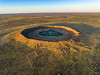
The crater averages about 875 metres in diameter, 60 metres from rim to present crater floor and it is estimated that the meteorite that formed it had a mass of about 50,000 tonnes, while the age is estimated to be less than 300,000 years (Pleistocene). Small numbers of iron meteorites have been found in the vicinity of the crater, as well as larger so-called 'shale-balls', rounded objects made of iron oxide, some weighing as much as 250 kg.
It was brought to the attention of scientists after being spotted during an aerial survey in 1947, investigated on the ground two months later, and reported in publication in 1949. The European name for the crater comes from a nearby creek, which was in turn named after Robert Wolfe (early reports misspell the name as Wolf Creek), a prospector and storekeeper during the gold rush that established the town of Halls Creek.
The local Djaru (Jaru) Aboriginal people refer to the crater as Kandimalal. There are multiple Dreaming stories about the formation of the crater. One such story describes the crater's round shape being formed by the passage of a rainbow snake out of the earth, while another snake formed the nearby Sturt Creek. Another story, as told by an Elder, is that one day the crescent moon and the evening star passed very close to each other. The evening star became so hot that it fell to the ground, causing an enormous explosion and flash, followed by a dust cloud. This frightened the people and a long time passed before they ventured near the crater to see what had happened. When they finally went there, they realised that this was the site where the evening star had fallen to the Earth. The Djaru people named the place "Kandimalal" and it is prominent in art from the region.
For an image click here
You may be viewing yesterday's version of this page. To see the most up to date information please register for a free account.
Do not use the above information on other web sites or publications without permission of the contributor.
Nearby Images from Flickr
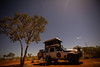
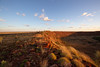
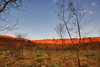
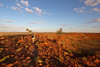
The above images may not be of the site on this page, but were taken nearby. They are loaded from Flickr so please click on them for image credits.
Click here to see more info for this site
Nearby sites
Click here to view sites on an interactive map of the areaKey: Red: member's photo, Blue: 3rd party photo, Yellow: other image, Green: no photo - please go there and take one, Grey: site destroyed
Download sites to:
KML (Google Earth)
GPX (GPS waypoints)
CSV (Garmin/Navman)
CSV (Excel)
To unlock full downloads you need to sign up as a Contributory Member. Otherwise downloads are limited to 50 sites.
Turn off the page maps and other distractions
Nearby sites listing. In the following links * = Image available
459.0km NNW 346° Drysdale River National Park Rock Art
561.2km NNW 347° Kalumburu Cave or Rock Shelter
693.9km ESE 104° Devil's Marbles* Natural Stone / Erratic / Other Natural Feature
763.0km SSE 155° Ayers Rock* Rock Art
815.7km SE 138° Henbury Meteorite Craters* Natural Stone / Erratic / Other Natural Feature
843.7km NE 37° Kakadu* Rock Art
920.0km NE 37° Kakadu - Madjedbebe* Cave or Rock Shelter
933.1km NE 37° Kakadu - Ubirr* Rock Art
992.7km WSW 243° Hope Downs Cave or Rock Shelter
1012.0km NE 41° Nawarla Gabarnmung rock art site Rock Art
1057.0km WSW 255° Nunyerry Creek* Rock Art
1109.6km WSW 248° Pibara Petroglyphs* Rock Art
1162.0km W 260° Burrup Peninsula* Rock Art
1199.4km N 357° Jerimalai Cave or Rock Shelter
1312.3km NW 322° Rindi Umalulu Burial Chamber or Dolmen
1359.6km NNW 326° Bena Village Megaliths* Ancient Village or Settlement
1375.7km S 172° Koonalda Cave Cave or Rock Shelter
1384.7km NW 319° Anakalang Burial Chamber or Dolmen
1390.1km NW 319° Waikabubak East Burial Chamber or Dolmen
1392.5km NW 318° Waikabubak Burial Chamber or Dolmen
1424.1km NW 325° Liang Bua Cave Cave or Rock Shelter
1703.1km SE 143° Warratyi* Cave or Rock Shelter
1706.5km SSW 209° Mulka's Cave* Rock Art
1721.7km SSW 209° Wave Rock* Natural Stone / Erratic / Other Natural Feature
1722.5km SSW 198° Esperance Stonehenge* Modern Stone Circle etc
View more nearby sites and additional images


 We would like to know more about this location. Please feel free to add a brief description and any relevant information in your own language.
 Wir möchten mehr über diese Stätte erfahren. Bitte zögern Sie nicht, eine kurze Beschreibung und relevante Informationen in Deutsch hinzuzufügen.
 Nous aimerions en savoir encore un peu sur les lieux. S'il vous plaît n'hesitez pas à ajouter une courte description et tous les renseignements pertinents dans votre propre langue.
 Quisieramos informarnos un poco más de las lugares. No dude en añadir una breve descripción y otros datos relevantes en su propio idioma.
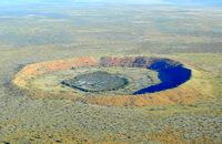