

<< Text Pages >> Drysdale River National Park - Rock Art in Australia
Submitted by Andy B on Tuesday, 11 May 2010 Page Views: 6600
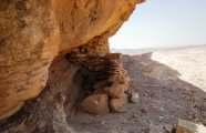
Rock ArtSite Name: Drysdale River National ParkCountry: Australia
NOTE: This site is 582.388 km away from the location you searched for.
Type: Rock Art
Nearest Town: Kalumburu
Latitude: 15.161389S Longitude: 126.776389E
Condition:
| 5 | Perfect |
| 4 | Almost Perfect |
| 3 | Reasonable but with some damage |
| 2 | Ruined but still recognisable as an ancient site |
| 1 | Pretty much destroyed, possibly visible as crop marks |
| 0 | No data. |
| -1 | Completely destroyed |
| 5 | Superb |
| 4 | Good |
| 3 | Ordinary |
| 2 | Not Good |
| 1 | Awful |
| 0 | No data. |
| 5 | Can be driven to, probably with disabled access |
| 4 | Short walk on a footpath |
| 3 | Requiring a bit more of a walk |
| 2 | A long walk |
| 1 | In the middle of nowhere, a nightmare to find |
| 0 | No data. |
| 5 | co-ordinates taken by GPS or official recorded co-ordinates |
| 4 | co-ordinates scaled from a detailed map |
| 3 | co-ordinates scaled from a bad map |
| 2 | co-ordinates of the nearest village |
| 1 | co-ordinates of the nearest town |
| 0 | no data |
Be the first person to rate this site - see the 'Contribute!' box in the right hand menu.
Internal Links:
External Links:
Rock Art sites in North Western Australia. Drysdale River National Park is a national park in the Kimberley region of Western Australia, 2,168 kilometres northeast of Perth.
The park lies about 100 km south of Kalumburu and 150 km west of Wyndham.
The park is the largest and least accessible in the Kimberley with no public road leading to it and no airstrip within its boundaries. Access to the park is gained via the track from Carson River Station from the Kalumburu Road. Permission must be obtained from the Kalumburu Aboriginal Corporation prior to entering the park. There are no visitor facilities or marked walk trails in the park. Rangers do not patrol the park and no food, fuel or mechanical services exist within the park or at Carson River Station.
The park is a good example of untouched Kimberley wilderness featuring open woodland, gorges, cliffs and the pools, waterfalls and creeks of the Drysdale River. The park is home to two large waterfalls: Morgan Falls and Solea Falls with numerous smaller falls along the course of the river.
Source: Wikipedia
Note: Scientists document scores of rock art sites in the Kimberley region of Australia, see comment
You may be viewing yesterday's version of this page. To see the most up to date information please register for a free account.
Do not use the above information on other web sites or publications without permission of the contributor.
Click here to see more info for this site
Nearby sites
Click here to view sites on an interactive map of the areaKey: Red: member's photo, Blue: 3rd party photo, Yellow: other image, Green: no photo - please go there and take one, Grey: site destroyed
Download sites to:
KML (Google Earth)
GPX (GPS waypoints)
CSV (Garmin/Navman)
CSV (Excel)
To unlock full downloads you need to sign up as a Contributory Member. Otherwise downloads are limited to 50 sites.
Turn off the page maps and other distractions
Nearby sites listing. In the following links * = Image available
102.4km N 350° Kalumburu Cave or Rock Shelter
459.0km SSE 167° Wolf Creek Crater Natural Stone / Erratic / Other Natural Feature
654.9km ENE 70° Kakadu* Rock Art
724.4km ENE 67° Kakadu - Madjedbebe* Cave or Rock Shelter
734.4km ENE 66° Kakadu - Ubirr* Rock Art
753.6km N 4° Jerimalai Cave or Rock Shelter
831.9km ENE 67° Nawarla Gabarnmung rock art site Rock Art
911.4km NW 311° Rindi Umalulu Burial Chamber or Dolmen
940.5km NW 317° Bena Village Megaliths* Ancient Village or Settlement
994.1km SE 128° Devil's Marbles* Natural Stone / Erratic / Other Natural Feature
997.7km NW 308° Anakalang Burial Chamber or Dolmen
1006.3km NW 307° Waikabubak East Burial Chamber or Dolmen
1008.9km NW 307° Waikabubak Burial Chamber or Dolmen
1009.0km NW 316° Liang Bua Cave Cave or Rock Shelter
1162.5km SW 232° Nunyerry Creek* Rock Art
1182.1km SW 222° Hope Downs Cave or Rock Shelter
1216.1km SSE 159° Ayers Rock* Rock Art
1218.5km WSW 239° Burrup Peninsula* Rock Art
1240.0km SSE 149° Henbury Meteorite Craters* Natural Stone / Erratic / Other Natural Feature
1261.9km SW 227° Pibara Petroglyphs* Rock Art
1372.7km NW 323° Maros (Sulawesi) Rock Art
1372.8km NW 325° Leang Leang Rock Art
1443.8km WNW 298° Pura Batu Pageh* Ancient Temple
1444.8km WNW 300° Pura Besakih Ancient Temple
1450.0km WNW 299° Goa Garba* Cave or Rock Shelter
View more nearby sites and additional images


 We would like to know more about this location. Please feel free to add a brief description and any relevant information in your own language.
 Wir möchten mehr über diese Stätte erfahren. Bitte zögern Sie nicht, eine kurze Beschreibung und relevante Informationen in Deutsch hinzuzufügen.
 Nous aimerions en savoir encore un peu sur les lieux. S'il vous plaît n'hesitez pas à ajouter une courte description et tous les renseignements pertinents dans votre propre langue.
 Quisieramos informarnos un poco más de las lugares. No dude en añadir una breve descripción y otros datos relevantes en su propio idioma.