


<< Text Pages >> Greifensteine - Natural Stone / Erratic / Other Natural Feature in Germany in Saxony
Submitted by KaiHofmann on Sunday, 07 June 2015 Page Views: 1125
Natural PlacesSite Name: GreifensteineCountry: Germany
NOTE: This site is 9.139 km away from the location you searched for.
Land: Saxony Type: Natural Stone / Erratic / Other Natural Feature
Nearest Town: Chemnitz Nearest Village: Ehrenfriedersdorf
Latitude: 50.648528N Longitude: 12.930848E
Condition:
| 5 | Perfect |
| 4 | Almost Perfect |
| 3 | Reasonable but with some damage |
| 2 | Ruined but still recognisable as an ancient site |
| 1 | Pretty much destroyed, possibly visible as crop marks |
| 0 | No data. |
| -1 | Completely destroyed |
| 5 | Superb |
| 4 | Good |
| 3 | Ordinary |
| 2 | Not Good |
| 1 | Awful |
| 0 | No data. |
| 5 | Can be driven to, probably with disabled access |
| 4 | Short walk on a footpath |
| 3 | Requiring a bit more of a walk |
| 2 | A long walk |
| 1 | In the middle of nowhere, a nightmare to find |
| 0 | No data. |
| 5 | co-ordinates taken by GPS or official recorded co-ordinates |
| 4 | co-ordinates scaled from a detailed map |
| 3 | co-ordinates scaled from a bad map |
| 2 | co-ordinates of the nearest village |
| 1 | co-ordinates of the nearest town |
| 0 | no data |
Internal Links:
External Links:
Natural Feature in Saxony
The Greifensteine are 7 tall rock pillars south of Zwickau. Many myths are told about these rocks in the local area. Today a touristic natural theatre lies in front of the rocks, so it could be that the site is overcrowded in summertime. A cave (Stülpner-Höhle) lies nearby.
You may be viewing yesterday's version of this page. To see the most up to date information please register for a free account.
Do not use the above information on other web sites or publications without permission of the contributor.
Nearby Images from Flickr

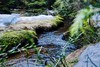


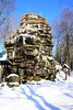
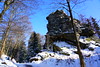
The above images may not be of the site on this page, but were taken nearby. They are loaded from Flickr so please click on them for image credits.
Click here to see more info for this site
Nearby sites
Click here to view sites on an interactive map of the areaKey: Red: member's photo, Blue: 3rd party photo, Yellow: other image, Green: no photo - please go there and take one, Grey: site destroyed
Download sites to:
KML (Google Earth)
GPX (GPS waypoints)
CSV (Garmin/Navman)
CSV (Excel)
To unlock full downloads you need to sign up as a Contributory Member. Otherwise downloads are limited to 50 sites.
Turn off the page maps and other distractions
Nearby sites listing. In the following links * = Image available
24.0km WNW 302° Stonehenge miniature* Modern Stone Circle etc
32.4km WSW 257° Taufstein von Pechtelsgrün Rock Art
32.9km SSE 157° Perštejn Celtic Park* Modern Stone Circle etc
33.6km SSE 156° Propitiatory Cross Černýš 2* Ancient Cross
33.6km SSE 156° Propitiatory Cross Černýš 1* Ancient Cross
38.1km SE 142° Crosses in Smetana Park* Ancient Cross
38.8km S 179° Ostrov Stone Cross 2* Ancient Cross
38.8km S 179° Ostrov Stone Cross 1* Ancient Cross
40.0km NE 44° Summstein Freiberg Modern Stone Circle etc
41.4km S 173° Radošov Hillfort* Hillfort
41.6km S 174° Radošov Propitiatory Cross* Ancient Cross
41.6km ESE 121° Chomutov Propitiatory Cross* Ancient Cross
41.8km SE 124° Generalsteine* Standing Stones
42.6km S 180° Stone Cross in Bor* Ancient Cross
44.0km ESE 122° Propitiatory Cross Údlice* Ancient Cross
44.7km S 184° Dalovice Stone Cross* Ancient Cross
45.3km SE 124° Všehrdy Propitiatory Cross* Ancient Cross
45.5km S 174° Gnomes Rocks* Cave or Rock Shelter
47.1km SSW 208° Stone Cross Jindřichovice* Ancient Cross
52.7km SW 223° Reliéfy Kostelní* Sculptured Stone
53.5km SW 224° Vysoký Kámen (Kostelní)* Rock Outcrop
54.5km SSW 200° Stone crosses Královské Poříčí* Ancient Cross
56.0km SSW 211° Krajkova Stone Cross* Ancient Cross
56.3km SE 130° Zakletá Panna* Standing Stone (Menhir)
56.7km N 353° Maaschwitz Barrow Cemetery
View more nearby sites and additional images


 We would like to know more about this location. Please feel free to add a brief description and any relevant information in your own language.
 Wir möchten mehr über diese Stätte erfahren. Bitte zögern Sie nicht, eine kurze Beschreibung und relevante Informationen in Deutsch hinzuzufügen.
 Nous aimerions en savoir encore un peu sur les lieux. S'il vous plaît n'hesitez pas à ajouter une courte description et tous les renseignements pertinents dans votre propre langue.
 Quisieramos informarnos un poco más de las lugares. No dude en añadir una breve descripción y otros datos relevantes en su propio idioma.