<< Our Photo Pages >> Tariat Deer Stone - Standing Stones in Mongolia
Submitted by UliWellner on Thursday, 02 January 2020 Page Views: 831
Neolithic and Bronze AgeSite Name: Tariat Deer StoneCountry: Mongolia
NOTE: This site is 447.241 km away from the location you searched for.
Type: Standing Stones
Nearest Village: Tariat
Latitude: 48.113414N Longitude: 99.484997E
Condition:
| 5 | Perfect |
| 4 | Almost Perfect |
| 3 | Reasonable but with some damage |
| 2 | Ruined but still recognisable as an ancient site |
| 1 | Pretty much destroyed, possibly visible as crop marks |
| 0 | No data. |
| -1 | Completely destroyed |
| 5 | Superb |
| 4 | Good |
| 3 | Ordinary |
| 2 | Not Good |
| 1 | Awful |
| 0 | No data. |
| 5 | Can be driven to, probably with disabled access |
| 4 | Short walk on a footpath |
| 3 | Requiring a bit more of a walk |
| 2 | A long walk |
| 1 | In the middle of nowhere, a nightmare to find |
| 0 | No data. |
| 5 | co-ordinates taken by GPS or official recorded co-ordinates |
| 4 | co-ordinates scaled from a detailed map |
| 3 | co-ordinates scaled from a bad map |
| 2 | co-ordinates of the nearest village |
| 1 | co-ordinates of the nearest town |
| 0 | no data |
Internal Links:
External Links:
")
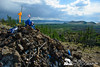
Deer stone and stone circles.
You may be viewing yesterday's version of this page. To see the most up to date information please register for a free account.
")
")
")
")
Do not use the above information on other web sites or publications without permission of the contributor.
Nearby Images from Flickr
The above images may not be of the site on this page, but were taken nearby. They are loaded from Flickr so please click on them for image credits.
Click here to see more info for this site
Nearby sites
Click here to view sites on an interactive map of the areaKey: Red: member's photo, Blue: 3rd party photo, Yellow: other image, Green: no photo - please go there and take one, Grey: site destroyed
Download sites to:
KML (Google Earth)
GPX (GPS waypoints)
CSV (Garmin/Navman)
CSV (Excel)
To unlock full downloads you need to sign up as a Contributory Member. Otherwise downloads are limited to 50 sites.
Turn off the page maps and other distractions
Nearby sites listing. In the following links * = Image available
174.5km N 11° Moron Deer Stones* Standing Stones
277.2km WNW 299° Lake Oygon Round Barrows Round Barrow(s)
539.9km NW 320° Republican Museum of Kyzyl* Museum
557.1km ENE 58° Orgoyton-2 Burial Ground* Chambered Tomb
557.5km ENE 58° Orgoyton-1 Burial Ground* Chambered Tomb
574.7km NE 35° Irkutsk Museum Of Regional Studies* Museum
603.1km NNE 27° Malta Paleolithic Settlement* Ancient Village or Settlement
604.4km NW 319° Arzhan Scythian royal necropolis* Barrow Cemetery
638.0km NW 310° Ancient sanctuary Chaa-Holl* Rock Cut Tomb
700.5km NE 52° Big Ivolginskoe settlement* Ancient Village or Settlement
709.0km NE 42° Sagan-Zaba Cape Rock Art
711.3km NE 51° Museum of Buryatia History* Museum
714.4km NE 51° Ethnographic Museum of Buryatia* Museum
719.6km NE 41° Sacred mountain Yord* Artificial Mound
785.7km NNE 31° Shishkino* Rock Art
814.2km W 277° Lake Hoton Standing Grave Stones* Standing Stones
820.2km W 278° Lake Hoton Round Barrow Round Barrow(s)
823.2km WNW 287° Tarhatinsky megalithic site* Standing Stones
826.1km W 278° Lake Hoton Petroglyphs* Rock Art
826.8km WNW 282° Mt. Shiveet altar stone with petroglyphs* Rock Art
831.6km WNW 282° Shiveet Mountain Petroglyphs* Rock Art
839.5km NW 321° Museum Kyzlasov L.R.* Museum
884.6km NW 320° Great Salbyk Kurgan* Pyramid / Mastaba
905.1km E 88° Duurlig Nars Burial Chamber or Dolmen
927.6km SW 234° Subeixi Cemeteries Barrow Cemetery
View more nearby sites and additional images


 We would like to know more about this location. Please feel free to add a brief description and any relevant information in your own language.
 Wir möchten mehr über diese Stätte erfahren. Bitte zögern Sie nicht, eine kurze Beschreibung und relevante Informationen in Deutsch hinzuzufügen.
 Nous aimerions en savoir encore un peu sur les lieux. S'il vous plaît n'hesitez pas à ajouter une courte description et tous les renseignements pertinents dans votre propre langue.
 Quisieramos informarnos un poco más de las lugares. No dude en añadir una breve descripción y otros datos relevantes en su propio idioma.