<< Our Photo Pages >> Nubsrud - Cairn in Norway in Akershus
Submitted by kenntha88 on Thursday, 26 October 2023 Page Views: 160
Neolithic and Bronze AgeSite Name: NubsrudCountry: Norway
NOTE: This site is 6.248 km away from the location you searched for.
Fylke: Akershus Type: Cairn
Nearest Town: Moss
Latitude: 59.569030N Longitude: 10.686829E
Condition:
| 5 | Perfect |
| 4 | Almost Perfect |
| 3 | Reasonable but with some damage |
| 2 | Ruined but still recognisable as an ancient site |
| 1 | Pretty much destroyed, possibly visible as crop marks |
| 0 | No data. |
| -1 | Completely destroyed |
| 5 | Superb |
| 4 | Good |
| 3 | Ordinary |
| 2 | Not Good |
| 1 | Awful |
| 0 | No data. |
| 5 | Can be driven to, probably with disabled access |
| 4 | Short walk on a footpath |
| 3 | Requiring a bit more of a walk |
| 2 | A long walk |
| 1 | In the middle of nowhere, a nightmare to find |
| 0 | No data. |
| 5 | co-ordinates taken by GPS or official recorded co-ordinates |
| 4 | co-ordinates scaled from a detailed map |
| 3 | co-ordinates scaled from a bad map |
| 2 | co-ordinates of the nearest village |
| 1 | co-ordinates of the nearest town |
| 0 | no data |
Internal Links:
External Links:
")
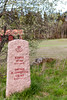
On the highest point of a small rocky hill covered in fir forest is a small round cairn. The hill is around 300 metres north of the nubsrud farm along a footpath. I came over the cairn while I was walking the footpath up to the Hauger stone circle.
The cairn is oval shaped, around 9X6 metres across and around 1 metre in height. Most of it is overgrown with moss but the rocks are still visible. It has a crater or depression in the center.
You may be viewing yesterday's version of this page. To see the most up to date information please register for a free account.
")
")
Do not use the above information on other web sites or publications without permission of the contributor.
Nearby Images from Flickr

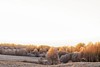
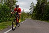


The above images may not be of the site on this page, but were taken nearby. They are loaded from Flickr so please click on them for image credits.
Click here to see more info for this site
Nearby sites
Click here to view sites on an interactive map of the areaKey: Red: member's photo, Blue: 3rd party photo, Yellow: other image, Green: no photo - please go there and take one, Grey: site destroyed
Download sites to:
KML (Google Earth)
GPX (GPS waypoints)
CSV (Garmin/Navman)
CSV (Excel)
To unlock full downloads you need to sign up as a Contributory Member. Otherwise downloads are limited to 50 sites.
Turn off the page maps and other distractions
Nearby sites listing. In the following links * = Image available
421m N 351° Hauger-Torp* Stone Circle
4.2km NE 35° Revhaugen (Vestby)* Round Barrow(s)
7.1km E 81° Enerås-Hovum* Barrow Cemetery
7.5km ENE 78° Nordre-Hovum/Hovtun* Barrow Cemetery
7.5km E 82° Garder* Barrow Cemetery
9.7km NE 35° Vardåsen* Hillfort
9.7km N 5° Rishaugen* Round Barrow(s)
10.1km N 10° Vestre Holstad* Round Barrow(s)
10.3km NNE 13° Haug Vestre* Round Barrow(s)
12.0km W 273° Holtvedtryggen* Stone Circle
12.9km NNE 24° Østby-Kongeveien* Barrow Cemetery
13.0km NNE 16° Kinnsås* Hillfort
13.9km SSE 151° Bergeråsen* Hillfort
14.4km NNE 31° Skuterudsletta* Barrow Cemetery
14.9km ESE 105° Bjørnefestningen* Hillfort
15.2km NE 37° Bernhus* Stone Circle
15.3km NE 43° Tomter* Stone Circle
15.7km WSW 256° Rødtangen Dolmen* Burial Chamber or Dolmen
15.8km WSW 257° Røysene Cairns* Clava Cairn
15.9km NE 41° Prestegårdshavna* Barrow Cemetery
16.2km NE 43° Kråkstad* Barrow Cemetery
17.8km NNE 16° Nordby-Østre* Barrow Cemetery
18.0km NE 40° St Hanshaugen* Round Barrow(s)
18.7km NE 39° Mellegård* Barrow Cemetery
19.2km S 183° Søsters Hvile* Barrow Cemetery
View more nearby sites and additional images


 We would like to know more about this location. Please feel free to add a brief description and any relevant information in your own language.
 Wir möchten mehr über diese Stätte erfahren. Bitte zögern Sie nicht, eine kurze Beschreibung und relevante Informationen in Deutsch hinzuzufügen.
 Nous aimerions en savoir encore un peu sur les lieux. S'il vous plaît n'hesitez pas à ajouter une courte description et tous les renseignements pertinents dans votre propre langue.
 Quisieramos informarnos un poco más de las lugares. No dude en añadir una breve descripción y otros datos relevantes en su propio idioma.