

<< Our Photo Pages >> Røysene Cairns - Clava Cairn in Norway in Buskerud
Submitted by kenntha88 on Thursday, 06 September 2012 Page Views: 2183
Neolithic and Bronze AgeSite Name: Røysene Cairns Alternative Name: RødtangenCountry: Norway Fylke: Buskerud Type: Clava Cairn
Nearest Town: Drammen Nearest Village: Rødtangen
Latitude: 59.536676N Longitude: 10.414588E
Condition:
| 5 | Perfect |
| 4 | Almost Perfect |
| 3 | Reasonable but with some damage |
| 2 | Ruined but still recognisable as an ancient site |
| 1 | Pretty much destroyed, possibly visible as crop marks |
| 0 | No data. |
| -1 | Completely destroyed |
| 5 | Superb |
| 4 | Good |
| 3 | Ordinary |
| 2 | Not Good |
| 1 | Awful |
| 0 | No data. |
| 5 | Can be driven to, probably with disabled access |
| 4 | Short walk on a footpath |
| 3 | Requiring a bit more of a walk |
| 2 | A long walk |
| 1 | In the middle of nowhere, a nightmare to find |
| 0 | No data. |
| 5 | co-ordinates taken by GPS or official recorded co-ordinates |
| 4 | co-ordinates scaled from a detailed map |
| 3 | co-ordinates scaled from a bad map |
| 2 | co-ordinates of the nearest village |
| 1 | co-ordinates of the nearest town |
| 0 | no data |
Internal Links:
External Links:
")
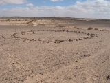
They have not been dated, but based on other cairns around the area, they are most probably from the bronze age or earlier iron age.
They are around 15-20m in diameter and from 2 to 3 metres in height. All of them have deep craters in the middle and inside the craters the stone coffins or burial chambers are visible.
The location has a beautiful view over the sea and a small path leads from the country road to the hilltop. Singposts have been placed to guide visitors to the cairns.
These type of cairns are usually called hill cairns because of their placement on small hills overlooking the sea. They are found everywhere along the coastline from the swedish border in the south to Finnmark in the north.
You may be viewing yesterday's version of this page. To see the most up to date information please register for a free account.
")
")
")
")
")
")
")
")
")
")
")
")
Do not use the above information on other web sites or publications without permission of the contributor.
Click here to see more info for this site
Nearby sites
Click here to view sites on an interactive map of the areaKey: Red: member's photo, Blue: 3rd party photo, Yellow: other image, Green: no photo - please go there and take one, Grey: site destroyed
Download sites to:
KML (Google Earth)
GPX (GPS waypoints)
CSV (Garmin/Navman)
CSV (Excel)
To unlock full downloads you need to sign up as a Contributory Member. Otherwise downloads are limited to 50 sites.
Turn off the page maps and other distractions
Nearby sites listing. In the following links * = Image available
170m SSE 161° Rødtangen Dolmen* Burial Chamber or Dolmen
5.4km NE 39° Holtvedtryggen* Stone Circle
12.1km WNW 299° Duni* Barrow Cemetery
12.3km S 184° Skånevetan* Hillfort
13.2km WNW 298° Hammerøi Mound* Round Barrow(s)
14.9km W 272° Stufsrudborgen Hillfort* Hillfort
15.8km ENE 77° Nubsrud* Cairn
15.8km ENE 75° Hauger-Torp* Stone Circle
16.4km WSW 243° Holmsvatnet-Tjuvberget Hillfort* Hillfort
17.1km S 170° Midgard vikingsenter* Museum
17.4km S 169° Borrehaugene* Barrow Cemetery
17.7km W 268° Haugestad* Barrow Cemetery
17.7km S 170° Spellemannshaugen* Round Barrow(s)
18.0km S 183° Adalsborgen Hillfort* Hillfort
18.0km W 264° Rønneberg* Barrow Cemetery
18.5km W 277° Østby-Kopstadlinna* Barrow Cemetery
19.0km W 271° Hof Skole* Barrow Cemetery
19.1km ENE 68° Revhaugen (Vestby)* Round Barrow(s)
20.2km SSW 197° Juliusåsen Hillfort* Hillfort
21.0km NE 51° Rishaugen* Round Barrow(s)
21.3km SE 137° Søsters Hvile* Barrow Cemetery
21.8km NE 51° Vestre Holstad* Round Barrow(s)
21.9km NNW 337° Åskollen* Rock Art
22.0km SE 139° Telemarkslunden* Stone Circle
22.0km SSW 205° Bergshaugen* Barrow Cemetery
View more nearby sites and additional images


 We would like to know more about this location. Please feel free to add a brief description and any relevant information in your own language.
 Wir möchten mehr über diese Stätte erfahren. Bitte zögern Sie nicht, eine kurze Beschreibung und relevante Informationen in Deutsch hinzuzufügen.
 Nous aimerions en savoir encore un peu sur les lieux. S'il vous plaît n'hesitez pas à ajouter une courte description et tous les renseignements pertinents dans votre propre langue.
 Quisieramos informarnos un poco más de las lugares. No dude en añadir una breve descripción y otros datos relevantes en su propio idioma.