


<< Other Photo Pages >> Chickasawba Mound - Artificial Mound in United States in The South
Submitted by AKFisher on Wednesday, 02 August 2023 Page Views: 498
Multi-periodSite Name: Chickasawba Mound Alternative Name: 3M55Country: United States
NOTE: This site is 53.328 km away from the location you searched for.
Region: The South Type: Artificial Mound
Nearest Town: Blytheville, AR
Latitude: 35.932430N Longitude: 89.93064W
Condition:
| 5 | Perfect |
| 4 | Almost Perfect |
| 3 | Reasonable but with some damage |
| 2 | Ruined but still recognisable as an ancient site |
| 1 | Pretty much destroyed, possibly visible as crop marks |
| 0 | No data. |
| -1 | Completely destroyed |
| 5 | Superb |
| 4 | Good |
| 3 | Ordinary |
| 2 | Not Good |
| 1 | Awful |
| 0 | No data. |
| 5 | Can be driven to, probably with disabled access |
| 4 | Short walk on a footpath |
| 3 | Requiring a bit more of a walk |
| 2 | A long walk |
| 1 | In the middle of nowhere, a nightmare to find |
| 0 | No data. |
| 5 | co-ordinates taken by GPS or official recorded co-ordinates |
| 4 | co-ordinates scaled from a detailed map |
| 3 | co-ordinates scaled from a bad map |
| 2 | co-ordinates of the nearest village |
| 1 | co-ordinates of the nearest town |
| 0 | no data |
Internal Links:
External Links:
")
From Wikipedia:
The Chickasawba Mound, designated by the Smithsonian trinomial 3M55, is an archaeological site in Blytheville, Arkansas. It encompasses the remains of a modest Nodena phase town, with a ceremonial mound and evidence of occupation during the 16th century. The site is one of the best-preserved Nodena sites in the region.[2] The site was listed on the National Register of Historic Places in 1984.[1] The site derives its name from Chickasawba, a chief of the Shawnee tribe, said to have been buried at the foot of the mound.[3]
References:
1. National Register Information System". National Register of Historic Places. National Park Service. July 9, 2010.
2. Summary description of Chickasawba Mound". Arkansas Preservation. Archived from the original on 2014-11-30. Retrieved 2014-11-28.
3. Jessop, Utahna; The "Arkansas Woman" and other Giants of The Ozarks, Ancient American, Vol. 24, Issue 126 (2020) p. 3-4, according to Zimmerman, Fritz, Remains of Giant Race Found in Arkansas, Idaho Daily Statesman, June 12, 1899. The 1899 article also claims, "an excavation in or near Chickasawba mound revealed a portion of a gigantic human skeleton - the man to whom it belongs could not have been less than eight or nine feet tall" and that similar skeletons have been found in the neighborhood of the mound.
Further reading and information:
Wikipedia
https://en.wikipedia.org/wiki/Chickasawba_Mound
Archaeology Conservancy
https://www.archaeologicalconservancy.org/chickasawba-arkansas/
Directions:
Within city limits of Blytheville, AR., Chickasawba St.
You may be viewing yesterday's version of this page. To see the most up to date information please register for a free account.
Do not use the above information on other web sites or publications without permission of the contributor.
Nearby Images from Flickr


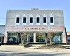
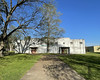
The above images may not be of the site on this page, but were taken nearby. They are loaded from Flickr so please click on them for image credits.
Click here to see more info for this site
Nearby sites
Click here to view sites on an interactive map of the areaKey: Red: member's photo, Blue: 3rd party photo, Yellow: other image, Green: no photo - please go there and take one, Grey: site destroyed
Download sites to:
KML (Google Earth)
GPX (GPS waypoints)
CSV (Garmin/Navman)
CSV (Excel)
To unlock full downloads you need to sign up as a Contributory Member. Otherwise downloads are limited to 50 sites.
Turn off the page maps and other distractions
Nearby sites listing. In the following links * = Image available
36.9km S 187° Nodena Site* Ancient Village or Settlement
41.5km SSW 194° Hampson* Museum
77.5km NNE 23° Lilbourn Mound Ancient Village or Settlement
80.7km SW 215° Richard's Bridge* Ancient Village or Settlement
85.7km SW 215° Berry Cemetery Mound* Artificial Mound
91.0km S 188° Chickasaw Heritage Park* Artificial Mound
92.3km SW 218° Parkin* Ancient Village or Settlement
97.0km NE 43° Adams Site* Artificial Mound
98.4km S 191° Chucalissa Prehistoric Indian Village* Museum
105.2km NE 36° Towosahgy Ancient Village or Settlement
107.7km SSW 194° Edgefield Mounds* Artificial Mound
108.9km NE 42° O'Bayum's Fort* Artificial Mound
109.6km SSW 192° Cheatham Mound* Artificial Mound
121.6km ESE 113° Pinson Mounds - Ozier Mound* Artificial Mound
121.7km ESE 113° Pinson Mounds - Twin Mounds* Artificial Mound
122.6km ESE 113° Pinson Mounds* Artificial Mound
122.7km ESE 113° Pinson Mounds - Other Sites* Artificial Mound
122.7km ESE 113° Pinson Mounds - Sauls Mound* Artificial Mound
123.3km ESE 113° Pinson Mounds - Mound 28* Artificial Mound
123.6km ESE 113° Pinson Mounds - Eastern Citadel* Misc. Earthwork
123.7km ESE 113° Pinson Mounds - Mound 30* Artificial Mound
130.5km SSW 199° Commerce Mounds* Artificial Mound
134.6km SSW 197° Hollywood Mounds* Artificial Mound
137.7km NNE 33° Wickliffe Mounds* Ancient Village or Settlement
138.3km SSW 197° Johnson Cemetery Mound* Artificial Mound
View more nearby sites and additional images


 We would like to know more about this location. Please feel free to add a brief description and any relevant information in your own language.
 Wir möchten mehr über diese Stätte erfahren. Bitte zögern Sie nicht, eine kurze Beschreibung und relevante Informationen in Deutsch hinzuzufügen.
 Nous aimerions en savoir encore un peu sur les lieux. S'il vous plaît n'hesitez pas à ajouter une courte description et tous les renseignements pertinents dans votre propre langue.
 Quisieramos informarnos un poco más de las lugares. No dude en añadir una breve descripción y otros datos relevantes en su propio idioma.