Featured: Hare and Tabor T Shirts for discerning antiquarians

Hare and Tabor T Shirts for discerning antiquarians

The Megalithic European

The Megalithic European

Who's Online

There are currently, 197 guests and 2 members online.

You are a guest. To join in, please register for free by clicking here

Sponsors

<< Our Photo Pages >> Pinson Mounds - Other Sites - Artificial Mound in United States in The South

Submitted by stonetracker on Friday, 19 April 2024  Page Views: 150

Multi-periodSite Name: Pinson Mounds - Other Sites
Country: United States Region: The South Type: Artificial Mound
Nearest Town: Pinson TN
Latitude: 35.494140N  Longitude: 88.68401W
Condition:
5Perfect
4Almost Perfect
3Reasonable but with some damage
2Ruined but still recognisable as an ancient site
1Pretty much destroyed, possibly visible as crop marks
0No data.
-1Completely destroyed
3 Ambience:
5Superb
4Good
3Ordinary
2Not Good
1Awful
0No data.
3 Access:
5Can be driven to, probably with disabled access
4Short walk on a footpath
3Requiring a bit more of a walk
2A long walk
1In the middle of nowhere, a nightmare to find
0No data.
3 Accuracy:
5co-ordinates taken by GPS or official recorded co-ordinates
4co-ordinates scaled from a detailed map
3co-ordinates scaled from a bad map
2co-ordinates of the nearest village
1co-ordinates of the nearest town
0no data
4

Internal Links:
External Links:

I have visited· I would like to visit

stonetracker visited on 1st Apr 2024 - their rating: Cond: 3 Amb: 4 Access: 3 See Pinson Mounds main page for my visitor log comments.

Pinson Mounds - Other Sites
Pinson Mounds - Other Sites submitted by stonetracker : Location coordinates: 35.49532, -88.68099 From a 1988 report published in American Antiquity, 1988, by Robert C. Mainfort, Jr: "Mound 10, an irregular-shaped mound measuring 61 m long, 40 m wide, and 1.3 m high, is located approximately 100 m east of Mound 9 (Sauls' Mound). The excavations demonstrated that Mound 10 was a flat-topped earthwork, and a large fire basin was expose... (Vote or comment on this photo)
Artificial Mound in The South

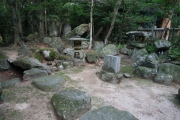
Aside from the famous Sauls' Mound and other major sites, there are a number of subordinate mounds, habitation, and non-mound sectors at Pinson that deserve mention. Many are in the Central Section, but a few others are scattered throughout the park. Coordinates and a description for each are provided in either the Comments or photos sections, wherever appropriate.

The overall location coordinates cited for sites in this article are for Mound 12, mainly because it is centrally located amongst all of the park features.
You may be viewing yesterday's version of this page. To see the most up to date information please register for a free account.


Pinson Mounds - Other Sites
Pinson Mounds - Other Sites submitted by stonetracker : Newer site interpretation. Robert C. Mainfort Jr. writes about Duck's Nest in American Antiquity [edited]: "A possible mortuary activity area in the Duck's Nest sector, located on a small rise about 150 m north of the "Duck's Nest", was tested in 1982. Deposits here were characterized by the presence of a dark, soil horizon averaging 20 cm thick that exhibited the highest artifact densit... (Vote or comment on this photo)

Pinson Mounds - Other Sites
Pinson Mounds - Other Sites submitted by stonetracker : Site interpretation (Vote or comment on this photo)

Pinson Mounds - Other Sites
Pinson Mounds - Other Sites submitted by stonetracker : Location Coordinates: 35.49034, -88.68378. The Duck's Nest is likely a former mound that now appears as a small depression in the center of a knoll overlooking the Forked Deer River. Because the site has the greatest density of artifacts of any excavated at Pinson, it is of great interest to archaeologists. (Vote or comment on this photo)

Pinson Mounds - Other Sites
Pinson Mounds - Other Sites submitted by stonetracker : Mound 15 interpretation (Vote or comment on this photo)

Pinson Mounds - Other Sites
Pinson Mounds - Other Sites submitted by stonetracker : Location Coordinates: 35.49082, -88.68585. Mound 15 is located about 600 meters SW of Sauls Mound on a bluff edge overlooking the Forked Deer River. It is a long, low platform mound about 50 meters on a side. Aside from auger tests, little is known about the mound other than it was likely built in a single construction event rather than composed of incrementally layered differential soils. ... (Vote or comment on this photo)

Pinson Mounds - Other Sites
Pinson Mounds - Other Sites submitted by stonetracker : More recent interpretation on the barrow pit.

Pinson Mounds - Other Sites
Pinson Mounds - Other Sites submitted by stonetracker : Location coordinates of the "barrow" pit for Sauls' Mound. Barrow pit interpretative sign. Barrow pit is a regional American English variant synonymous with the more conventional archaeological term "borrow pit."

Pinson Mounds - Other Sites
Pinson Mounds - Other Sites submitted by stonetracker : Mound 14 Sector interpretation

Pinson Mounds - Other Sites
Pinson Mounds - Other Sites submitted by stonetracker : Location Coordinates: 35.493033, -88.685533. This is the Mound 14 Sector and the only habitation area excavated at Pinson that included a Mississippian Period wall trench-style house. It is now thought that it was the site of a minor Mississippian Period re-occupation that occurred long after the largely Middle Woodland Pinson site was abandoned. From Robert C. Mainfort Jr's report...

Pinson Mounds - Other Sites
Pinson Mounds - Other Sites submitted by stonetracker : Mound 12 interpretation

Pinson Mounds - Other Sites
Pinson Mounds - Other Sites submitted by stonetracker : Location coordinates: 35.49415, -88.68402 Mound 12 is a Middle Woodland burial mound built on top of a pre-mound Early Woodland occupation site (Mound 12 Sector). From Robert C. Mainfort, Jr's report in American Antiquity on the Middle Woodland mound itself: "This conical earthwork, measuring approximately 24 x 17 m at the base, with a height of 1.5 m, was built over a low, clay pl...

Pinson Mounds - Other Sites
Pinson Mounds - Other Sites submitted by stonetracker : Mound 11 Sector. Not a mound at all but what is believed to be a temporary habitation area. It is in the background of the photo on a slight rise to the right of the museum. (1 comment)

Pinson Mounds - Other Sites
Pinson Mounds - Other Sites submitted by stonetracker : Mound 10 interpretation

Do not use the above information on other web sites or publications without permission of the contributor.
Click here to see more info for this site

Nearby sites

Click here to view sites on an interactive map of the area

Key: Red: member's photo, Blue: 3rd party photo, Yellow: other image, Green: no photo - please go there and take one, Grey: site destroyed

Download sites to:
KML (Google Earth)
GPX (GPS waypoints)
CSV (Garmin/Navman)
CSV (Excel)

To unlock full downloads you need to sign up as a Contributory Member. Otherwise downloads are limited to 50 sites.


Turn off the page maps and other distractions

Nearby sites listing. In the following links * = Image available
 209m NE 42° Pinson Mounds - Sauls Mound* Artificial Mound
 446m NNE 21° Pinson Mounds* Artificial Mound
 976m WNW 289° Pinson Mounds - Twin Mounds* Artificial Mound
 1.1km WNW 302° Pinson Mounds - Ozier Mound* Artificial Mound
 1.1km E 81° Pinson Mounds - Eastern Citadel* Misc. Earthwork
 1.2km E 87° Pinson Mounds - Mound 30* Artificial Mound
 1.2km NE 54° Pinson Mounds - Mound 28* Artificial Mound
 50.9km SE 140° Shiloh Indian Mounds* Ancient Village or Settlement
 104.9km NNE 15° Obion Mounds* Artificial Mound
 106.9km SSE 152° Bear Creek* Ancient Village or Settlement
 116.6km SSE 168° Pharr Mounds* Artificial Mound
 117.8km W 276° Nodena Site* Ancient Village or Settlement
 120.9km SE 130° Florence Mound* Artificial Mound
 122.7km WNW 294° Chickasawba Mound* Artificial Mound
 123.0km W 274° Hampson* Museum
 126.4km SSW 195° Ingomar Mounds* Artificial Mound
 128.5km NNW 339° Adams Site* Artificial Mound
 132.7km WSW 252° Chickasaw Heritage Park* Artificial Mound
 135.8km NNW 343° O'Bayum's Fort* Artificial Mound
 139.7km WSW 250° Chucalissa Prehistoric Indian Village* Museum
 142.3km NNW 340° Towosahgy Ancient Village or Settlement
 144.8km NW 326° Lilbourn Mound Ancient Village or Settlement
 147.7km WSW 247° Cheatham Mound* Artificial Mound
 148.6km S 174° Mound Cemetary* Artificial Mound
 149.8km WSW 249° Edgefield Mounds* Artificial Mound
View more nearby sites and additional images

<< Yacimiento Arqueológico La Bastida

Trevalga Cross >>

Please add your thoughts on this site

Cornovia: Ancient Sites of Cornwall and Scilly, Craig Weatherhill

Cornovia: Ancient Sites of Cornwall and Scilly, Craig Weatherhill

Sponsors

Auto-Translation (Google)

Translate from English into:

"Pinson Mounds - Other Sites" | Login/Create an Account | 8 News and Comments
  
Go back to top of page    Comments are owned by the poster. We aren't responsible for their content.
Re: Pinson Mounds - Other Sites by stonetracker on Thursday, 25 April 2024
(User Info | Send a Message)
Duck's Nest video commentary:

photos.app.goo.gl/5131ApkYJYUwT98EA
[ Reply to This ]

Re: Pinson Mounds - Other Sites by stonetracker on Wednesday, 24 April 2024
(User Info | Send a Message)
Mound 15 video commentary:

photos.app.goo.gl/e6TfGkisuN5qKdhX6
[ Reply to This ]

Re: Pinson Mounds - Other Sites by stonetracker on Monday, 22 April 2024
(User Info | Send a Message)
Video commentary on the "barrow" pit. This is thought to be the source of construction material for Sauls Mound:

photos.app.goo.gl/XDFzq9XqANJfnHMGA
[ Reply to This ]

Re: Pinson Mounds - Other Sites by stonetracker on Monday, 22 April 2024
(User Info | Send a Message)
Mound 14 Sector video commentary:

photos.app.goo.gl/UMaENKbi7yCV5vJMA
[ Reply to This ]

Re: Pinson Mounds - Other Sites by stonetracker on Sunday, 21 April 2024
(User Info | Send a Message)
Mound 12 Sector is thought to be a temporary habitation area that pre-dates Mound 12 by roughly 200 years.

Location coordinates: 35.49455, -88.68293. This is approximately at the center of the sector, a large, flat parcel.

Mound 12 Sector video commentary:

photos.app.goo.gl/k7Uk9eoCzxGGtJyR6

And more from Robert C. Mainfort Jr's report in American Antiquity:

"Excavations in the Mound 12 sector (northeast of Mound 12) uncovered the remains of two ovoid bent-pole houses, a style typical for the Middle Woodland period in the Mid-South (e.g., Cotter and Corbett 1951). The larger of these was about 5 m in diameter and lacked associated features and cultural remains, but a second, slightly smaller structure contained a crematory basin in which several human bone stains were observed. Also associated with this feature were several sherds of a grog-tempered, red-filmed ware of non-local origin. Two radiocarbon dates indicate that the houses were built around A.D. 280, considerably earlier than Mound 12 nearby, but contemporary with the upper occupation stratum below Mound 12 (Mainfort 1980:15-18; Mainfort et a!. 1982...)."
[ Reply to This ]

Re: Pinson Mounds - Other Sites by stonetracker on Saturday, 20 April 2024
(User Info | Send a Message)
Mound 12 video commentary:

photos.app.goo.gl/gFDnoUEs2ZcoGPqv9

And a view from the opposite side:

photos.app.goo.gl/JQZ7SX3PYecyY6uo6
[ Reply to This ]

Re: Pinson Mounds - Other Sites by stonetracker on Friday, 19 April 2024
(User Info | Send a Message)
Mound 11 Sector video commentary:

photos.app.goo.gl/rawoQ4dCNENPiNyX6
[ Reply to This ]

Re: Pinson Mounds - Other Sites by stonetracker on Friday, 19 April 2024
(User Info | Send a Message)
Mound 10 video commentary:

photos.app.goo.gl/48Z5VkxQUsYPGG4T6
[ Reply to This ]

Your Name: Anonymous [ Register Now ]
Subject:


Add your comment or contribution to this page. Spam or offensive posts are deleted immediately, don't even bother

<<< What is five plus one as a number? (Please type the answer to this question in the little box on the left)
You can also embed videos and other things. For Youtube please copy and paste the 'embed code'.
For Google Street View please include Street View in the text.
Create a web link like this: <a href="https://www.megalithic.co.uk">This is a link</a>  

Allowed HTML is:
<p> <b> <i> <a> <img> <em> <br> <strong> <blockquote> <tt> <li> <ol> <ul> <object> <param> <embed> <iframe>

We would like to know more about this location. Please feel free to add a brief description and any relevant information in your own language.
Wir möchten mehr über diese Stätte erfahren. Bitte zögern Sie nicht, eine kurze Beschreibung und relevante Informationen in Deutsch hinzuzufügen.
Nous aimerions en savoir encore un peu sur les lieux. S'il vous plaît n'hesitez pas à ajouter une courte description et tous les renseignements pertinents dans votre propre langue.
Quisieramos informarnos un poco más de las lugares. No dude en añadir una breve descripción y otros datos relevantes en su propio idioma.