


<< Text Pages >> Illauntannig Island - Ancient Cross in Ireland (Republic of) in Co. Kerry
Submitted by Sunny100 on Tuesday, 08 November 2011 Page Views: 4398
Early Medieval (Dark Age)Site Name: Illauntannig Island Alternative Name: Oilean Sennaigh, St Sennach's IslandCountry: Ireland (Republic of)
NOTE: This site is 14.824 km away from the location you searched for.
County: Co. Kerry Type: Ancient Cross
Nearest Town: Castlegregory Nearest Village: Fahamore
Map Ref: Q621211
Latitude: 52.324641N Longitude: 10.023347W
Condition:
| 5 | Perfect |
| 4 | Almost Perfect |
| 3 | Reasonable but with some damage |
| 2 | Ruined but still recognisable as an ancient site |
| 1 | Pretty much destroyed, possibly visible as crop marks |
| 0 | No data. |
| -1 | Completely destroyed |
| 5 | Superb |
| 4 | Good |
| 3 | Ordinary |
| 2 | Not Good |
| 1 | Awful |
| 0 | No data. |
| 5 | Can be driven to, probably with disabled access |
| 4 | Short walk on a footpath |
| 3 | Requiring a bit more of a walk |
| 2 | A long walk |
| 1 | In the middle of nowhere, a nightmare to find |
| 0 | No data. |
| 5 | co-ordinates taken by GPS or official recorded co-ordinates |
| 4 | co-ordinates scaled from a detailed map |
| 3 | co-ordinates scaled from a bad map |
| 2 | co-ordinates of the nearest village |
| 1 | co-ordinates of the nearest town |
| 0 | no data |
Internal Links:
External Links:
Ancient Cross in Co. Kerry
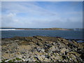
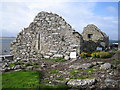
The island of Illauntannig (Oilean Sennaigh) is located 5 miles north of Castlegregory and a mile or so off the northern coast of the Dingle Peninsula. On the island are the remains of a 6th century monatery, founded by St Sennach, and a ruined medieval church in a monastic burial ground. Also, there is a Celtic cross, three bee-hive huts, two oratories, souterain and two roughly built stone altars, all enclosed within a cashel wall.
The Celtic cross is 5-6 feet tall and is made from a thin slab of stone; it is referred to as a three-armed slab cross but other than that rather a plain or crude monument. At its side, down on the ground, is a flat stone with a small hole at its centre - this was probably used for baptisms. At the other side of the cross a large dry-stone altar (leacht) stands right up against the cross - one of two at this site.
The three bee-hive huts or hermits cells still stand to there original height but they are now roofless. Nothing much remains of the 6th century monastery apart from a ruined church once dedicated to St Sennach or Seannach, a disciple of St Finnian, who died between 580-590 CE. His brother was the famous St Senan of Scattery Island.
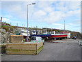
[Please note you will need to make use of a boat to get to the island, its to far to swim, so please enquire at the village of Fahamore on the Dingle Peninsula].
You may be viewing yesterday's version of this page. To see the most up to date information please register for a free account.
Do not use the above information on other web sites or publications without permission of the contributor.
Nearby Images from Geograph Britain and Ireland:
©2006(licence)
©2013(licence)
©2006(licence)
©2015(licence)
©2018(licence)
The above images may not be of the site on this page, they are loaded from Geograph.
Please Submit an Image of this site or go out and take one for us!
Click here to see more info for this site
Nearby sites
Click here to view sites on an interactive map of the areaKey: Red: member's photo, Blue: 3rd party photo, Yellow: other image, Green: no photo - please go there and take one, Grey: site destroyed
Download sites to:
KML (Google Earth)
GPX (GPS waypoints)
CSV (Garmin/Navman)
CSV (Excel)
To unlock full downloads you need to sign up as a Contributory Member. Otherwise downloads are limited to 50 sites.
Turn off the page maps and other distractions
Nearby sites listing. In the following links * = Image available
2.1km W 266° Illaunimnal Stone Circle (Q600210)
12.7km SSE 148° Ballygarret Stone Row / Alignment (Q685101)
13.3km SW 220° Drom E Standing Stones (Q53181124)
13.7km SW 231° Cloonsherragh Stone Row / Alignment (Q511128)
14.8km SE 145° Curraduff Stone Row* Stone Row / Alignment (Q703088)
15.0km WSW 249° Meenanare Stone Circle (Q479162)
15.9km SW 214° Ballyhoneen Wedge Tomb* Wedge Tomb
16.2km S 188° Dromvally SE* Standing Stones (Q59440514)
16.8km S 186° Derrygorman Standing Stones (Q599044)
17.3km SSW 191° Coumduff Standing Stones (Q58200418)
20.0km SSE 159° Caherpiece Standing Stone (Menhir)
20.6km WSW 237° Brandon Mountain Modern Stone Circle etc (Q445103)
21.1km SSW 204° Gownlaneard Standing Stones (Q53050203)
22.5km SSW 202° An Gráig standing stone* Standing Stone (Menhir)
22.6km SW 214° Ballyrishteen Standing Stones (Q489027)
23.3km SSW 204° Ardamore* Stone Row / Alignment (Q521000)
23.6km SSW 199° Minard W Standing Stones (V536991)
23.7km SSW 202° Dún na Manach wedge tomb* Wedge Tomb
24.0km SSW 205° Áth an Charbaill rock art* Rock Art
25.0km SSW 208° Kinard East* Carving (V496994)
25.1km SW 235° Corr Aille Spiral* Rock Art
25.7km SW 228° Knockavrogeen E Standing Stones (Q42580434)
26.3km SW 226° Kilfountan Standing Stone* Standing Stone (Menhir) (Q425035)
26.3km SW 234° Kilmalkedar Ogham Stone* Standing Stone (Menhir) (Q403062)
26.4km SW 234° Kilmalkedar Early Christian Sculptured Stone* Early Christian Sculptured Stone (Q40230622)
View more nearby sites and additional images


 We would like to know more about this location. Please feel free to add a brief description and any relevant information in your own language.
 Wir möchten mehr über diese Stätte erfahren. Bitte zögern Sie nicht, eine kurze Beschreibung und relevante Informationen in Deutsch hinzuzufügen.
 Nous aimerions en savoir encore un peu sur les lieux. S'il vous plaît n'hesitez pas à ajouter une courte description et tous les renseignements pertinents dans votre propre langue.
 Quisieramos informarnos un poco más de las lugares. No dude en añadir una breve descripción y otros datos relevantes en su propio idioma.