<< Our Photo Pages >> Fossa Stone - Standing Stone (Menhir) in Ireland (Republic of) in Co. Kerry
Submitted by markj99 on Sunday, 18 October 2020 Page Views: 1125
Neolithic and Bronze AgeSite Name: Fossa StoneCountry: Ireland (Republic of) County: Co. Kerry Type: Standing Stone (Menhir)
Nearest Town: Killarney Nearest Village: Fossa
Map Ref: V91169216
Latitude: 52.071194N Longitude: 9.588026W
Condition:
| 5 | Perfect |
| 4 | Almost Perfect |
| 3 | Reasonable but with some damage |
| 2 | Ruined but still recognisable as an ancient site |
| 1 | Pretty much destroyed, possibly visible as crop marks |
| 0 | No data. |
| -1 | Completely destroyed |
| 5 | Superb |
| 4 | Good |
| 3 | Ordinary |
| 2 | Not Good |
| 1 | Awful |
| 0 | No data. |
| 5 | Can be driven to, probably with disabled access |
| 4 | Short walk on a footpath |
| 3 | Requiring a bit more of a walk |
| 2 | A long walk |
| 1 | In the middle of nowhere, a nightmare to find |
| 0 | No data. |
| 5 | co-ordinates taken by GPS or official recorded co-ordinates |
| 4 | co-ordinates scaled from a detailed map |
| 3 | co-ordinates scaled from a bad map |
| 2 | co-ordinates of the nearest village |
| 1 | co-ordinates of the nearest town |
| 0 | no data |
Internal Links:
External Links:
")
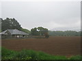
Fossa Standing Stone is an imposing stone in Fossa, a small village 7 km W of Killarney. It is listed as KE066-011 in the Irish Monuments Records. The stone measures 2.45 m in height and has a 1.8 x 1.77m cross section. It is situated in a small field adjacent to Forest Lake Grove, Fossa.
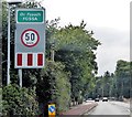
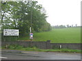
There is room to park on the R at a gate just after the 50 kph speed limit ends. The stone is 100 yards W from this gate.
Directions: From Killarney take the N72 Killorglin W for 7 km to Fossa. After you pass the Fossa Holiday Hostel on the R you will reach the 60 kph speed limit. Park on the R 50 m later in a wide gateway.
You may be viewing yesterday's version of this page. To see the most up to date information please register for a free account.
")
")
Do not use the above information on other web sites or publications without permission of the contributor.
Nearby Images from Geograph Britain and Ireland:
©2018(licence)

©2014(licence)
©2009(licence)
©2020(licence)
©2009(licence)
The above images may not be of the site on this page, they are loaded from Geograph.
Please Submit an Image of this site or go out and take one for us!
Click here to see more info for this site
Nearby sites
Click here to view sites on an interactive map of the areaKey: Red: member's photo, Blue: 3rd party photo, Yellow: other image, Green: no photo - please go there and take one, Grey: site destroyed
Download sites to:
KML (Google Earth)
GPX (GPS waypoints)
CSV (Garmin/Navman)
CSV (Excel)
To unlock full downloads you need to sign up as a Contributory Member. Otherwise downloads are limited to 50 sites.
Turn off the page maps and other distractions
Nearby sites listing. In the following links * = Image available
3.4km WSW 249° Coomagort ogham stones* Standing Stones
7.6km E 95° Park Standing Stone * Standing Stone (Menhir) (V98729131)
8.7km E 99° Lissyviggeen Standing Stones (V997906)
8.8km E 99° Lissyviggeen* Stone Circle (V998906)
11.1km E 100° Ardaneanig Row* Stone Row / Alignment (W02139003)
11.2km S 174° Gertroe Stone Circle (V920810)
12.0km S 174° Esknamucky glen* Standing Stone (Menhir) (V922802)
14.5km SW 219° Bunbinnia hut site and standing stone* Ancient Village or Settlement
15.1km SW 226° Curraghmore Stone Row / Alignment (V801819)
17.6km S 177° Inchimore* Cairn (V91827460)
17.7km SE 132° Derrybanane* Wedge Tomb (W0411580006)
17.8km S 181° Carhoonmeengar East* Rock Art (V9040274338)
18.2km SSW 201° Boughill* Standing Stone (Menhir) (V8422075275)
18.3km ENE 61° Knockrower West Stone Row / Alignment
18.7km NE 46° Scartaglin* Stone Circle (R05050479)
18.8km SW 232° Dromteewakeen Stone Row / Alignment (V761808)
19.8km SSW 197° Rossacoosane* Rock Art (V848734)
20.6km SW 224° Derrynablaha* Rock Art (V764778)
20.6km SW 223° Derrynablaha Stone Row* Standing Stone (Menhir) (V7666077519)
20.6km S 175° Killowen* Stone Circle (V924716)
21.0km SW 216° Derrylicka* Stone Row / Alignment (V784754)
21.1km SSE 168° Dromatouk circle* Stone Circle (V953714)
21.2km SSE 168° Dromatouk stones* Standing Stones (V9503771325)
21.3km SSE 151° Churchground bullaun stone* Sculptured Stone
21.4km S 180° Kenmare* Stone Circle (V9067970713)
View more nearby sites and additional images


 We would like to know more about this location. Please feel free to add a brief description and any relevant information in your own language.
 Wir möchten mehr über diese Stätte erfahren. Bitte zögern Sie nicht, eine kurze Beschreibung und relevante Informationen in Deutsch hinzuzufügen.
 Nous aimerions en savoir encore un peu sur les lieux. S'il vous plaît n'hesitez pas à ajouter une courte description et tous les renseignements pertinents dans votre propre langue.
 Quisieramos informarnos un poco más de las lugares. No dude en añadir una breve descripción y otros datos relevantes en su propio idioma.