

<< Text Pages >> Cranberry Creek Mound Group - Artificial Mound in United States in Great Lakes Midwest
Submitted by AKFisher on Tuesday, 08 August 2023 Page Views: 295
Multi-periodSite Name: Cranberry Creek Mound Group Alternative Name: Cranberry Creek Archaeological District, Cranberry Creek MoundsCountry: United States
NOTE: This site is 56.498 km away from the location you searched for.
Region: Great Lakes Midwest Type: Artificial Mound
Nearest Town: Necedah, WI Nearest Village: New Miner, WI
Latitude: 44.165040N Longitude: 90.06303W
Condition:
| 5 | Perfect |
| 4 | Almost Perfect |
| 3 | Reasonable but with some damage |
| 2 | Ruined but still recognisable as an ancient site |
| 1 | Pretty much destroyed, possibly visible as crop marks |
| 0 | No data. |
| -1 | Completely destroyed |
| 5 | Superb |
| 4 | Good |
| 3 | Ordinary |
| 2 | Not Good |
| 1 | Awful |
| 0 | No data. |
| 5 | Can be driven to, probably with disabled access |
| 4 | Short walk on a footpath |
| 3 | Requiring a bit more of a walk |
| 2 | A long walk |
| 1 | In the middle of nowhere, a nightmare to find |
| 0 | No data. |
| 5 | co-ordinates taken by GPS or official recorded co-ordinates |
| 4 | co-ordinates scaled from a detailed map |
| 3 | co-ordinates scaled from a bad map |
| 2 | co-ordinates of the nearest village |
| 1 | co-ordinates of the nearest town |
| 0 | no data |
Internal Links:
External Links:
Artificial Mound in Great Lakes Midwest
Cranberry Creek Archaeological District
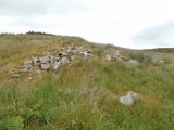
Cranberry Creek Archeological District, also known as Cranberry Creek Mound Group, is an ancient American Indian burial mound site from circa AD 100–800 near New Miner, Wisconsin, United States. It is three miles east of Necedah National Wildlife Refuge in Juneau County.[3] It is part of the "effigy mound culture" of native peoples in Wisconsin, who practiced the "respectful burial of their dead".[4]
History:
Humans first inhabited Wisconsin about 12,000 years ago, and the use of burial mounds developed in between 500 BC to 1000 AD during what is referred to as the Woodland period. The burial mounds during the late Woodland period tended to be built as effigies of birds, bears, and panthers, and examples of these can be found in the Cranberry Creek Archeological District.[4] As with other burial mounds on state property, the mounds in this region are protected against unauthorized disturbance.[4][5] Many of the best examples of mounds in this area are on the east side of Cranberry Creek. In addition to effigies, conical, linear, and oval mounds are found. Although archeological studies have been conducted here since 1917, and farming has damaged parts of the northern cluster, the cluster in the southern section is essentially unaltered by modern man.[6] Cranberry Creek Archeological District encompasses one of the larger mound groups in Wisconsin with over 300 mounds,[5] and possibly up to 500 mounds.[7]
Cranberry Creek Mound Group is owned by the Wisconsin Department of Natural Resources, and covers 675 acres (273 ha). The area is heavily forested, containing river birch, silver maple, red maple, jack pine, and oak. It is a State Natural Area since 1986.[6][8]
In addition to the Cranberry Creek Archeological District, Juneau County has two other related National Register of Historic Places: Gee's Slough Mound Group (ref: 78000108), which is also from the Woodland culture, and Lemonweir Glyphs (ref: 93001173).[1][9]
References:
1. National Register Information System. National Register of Historic Places. National Park Service. July 9, 2010.
2. Federal and state laws and practices restrict general public access to information regarding the specific location of this resource. In some cases, this is to protect archeological sites from vandalism, while in other cases it is restricted at the request of the owner. See: Knoerl, John; Miller, Diane; Shrimpton, Rebecca H. (1990), Guidelines for Restricting Information about Historic and Prehistoric Resources, National Register Bulletin, National Park Service, U.S. Department of the Interior, OCLC 20706997.
3. Chapter 3: Refuge Environment (PDF). Necedah National Wildlife Refuge Comprehensive Conservation Plan. Washington, D.C.: U.S. Fish and Wildlife Service. p. 23. Retrieved January 27, 2012.
4. Burial Mounds in Wisconsin. Wisconsin Department of Natural Resources. Archived from the original on August 31, 2011. Retrieved January 27, 2012.
5. Birmingham, Robert A.; Leslie E. Eisenberg (2000). Indian Mounds of Wisconsin. Madison, WI: University of Wisconsin Press. pp. 6, 110. ISBN 978-0-299-16874-2. Retrieved January 27, 2012. cranberry.
6. Cranberry Creek Mound Group (No. 203). Wisconsin Department of Natural Resources. Retrieved January 27, 2012.
7. Ostergren, Robert Clifford; Thomas R. Vale (1997). Wisconsin Land and Life. Madison, WI: University of Wisconsin Press. pp. 341–344, 350. ISBN 978-0-299-15350-2. Retrieved January 27, 2012.
8. Cranberry Creek Mound Group State Natural Area. Great Wisconsin and Birding Trail. Retrieved January 27, 2012.
9. New Lisbon Chamber of Commerce. Native American Effigy Mounds. Archived from the original on July 14, 2006. Retrieved January 27, 2012.
Further reading and information:
Boszhardt, Robert F. (1987). Mapping Mounds in the Cranberry Creek Archaeological District Year 1: An Example of Cooperative Archaeology in Wisconsin. Madison, WI: Mississippi Valley Archaeological Center at the University of Wisconsin-La Crosse. OCLC 27403160.
Directions:
From Necedah, WI via County Rd. G, 11.1 mi.
You may be viewing yesterday's version of this page. To see the most up to date information please register for a free account.
")
Do not use the above information on other web sites or publications without permission of the contributor.
Click here to see more info for this site
Nearby sites
Click here to view sites on an interactive map of the areaKey: Red: member's photo, Blue: 3rd party photo, Yellow: other image, Green: no photo - please go there and take one, Grey: site destroyed
Download sites to:
KML (Google Earth)
GPX (GPS waypoints)
CSV (Garmin/Navman)
CSV (Excel)
To unlock full downloads you need to sign up as a Contributory Member. Otherwise downloads are limited to 50 sites.
Turn off the page maps and other distractions
Nearby sites listing. In the following links * = Image available
52.5km WSW 252° Fort McCoy Artificial Mound
81.5km SSE 157° Man Mound Park* Artificial Mound
88.0km SSE 161° Devil's Lake Mounds* Artificial Mound
103.4km SSW 213° Tainter Cave Cave or Rock Shelter
122.6km S 174° Brighid's Spring at Circle Sanctuary* Holy Well or Sacred Spring
122.8km S 173° Circle Sanctuary Nature Preserve* Modern Stone Circle etc
125.5km SW 231° Fish Farm Mounds State Preserve Artificial Mound
132.6km SSE 157° Forest Hill Cemetery* Artificial Mound
134.0km SE 125° Nitschke Mounds State Park Artificial Mound
135.1km SW 215° Larsen Cave, Crawford Co* Rock Art
149.9km SW 217° Effigy Mounds National Monument* Artificial Mound
155.8km SE 141° Aztalan State Park* Ancient Village or Settlement
156.8km SSW 213° Wyalusing Mounds* Artificial Mound
171.1km SSE 147° Lake Koshkonong Mounds* Artificial Mound
172.2km SE 146° The Finch Site Ancient Village or Settlement
172.9km ESE 116° Lizard Mound State Park* Artificial Mound
191.6km SSW 194° Dunleith Mounds* Artificial Mound
195.5km SE 130° Cutler Mound Group* Artificial Mound
200.8km WNW 285° Bow and Arrow Rock Art
202.8km SSE 155° Beloit College Mounds* Artificial Mound
224.5km SSE 159° Beattie Park Mound Group* Misc. Earthwork
230.5km WNW 292° Rattlesnake Mound Artificial Mound
242.3km ENE 61° Chambers Island Mounds* Artificial Mound
242.5km SE 131° Mound Cemetery (Racine) Barrow Cemetery
252.6km WNW 291° Indian Mounds Regional Park* Artificial Mound
View more nearby sites and additional images


 We would like to know more about this location. Please feel free to add a brief description and any relevant information in your own language.
 Wir möchten mehr über diese Stätte erfahren. Bitte zögern Sie nicht, eine kurze Beschreibung und relevante Informationen in Deutsch hinzuzufügen.
 Nous aimerions en savoir encore un peu sur les lieux. S'il vous plaît n'hesitez pas à ajouter une courte description et tous les renseignements pertinents dans votre propre langue.
 Quisieramos informarnos un poco más de las lugares. No dude en añadir una breve descripción y otros datos relevantes en su propio idioma.