


<< Text Pages >> Nitschke Mounds State Park - Artificial Mound in United States in Great Lakes Midwest
Submitted by AKFisher on Wednesday, 09 August 2023 Page Views: 258
Multi-periodSite Name: Nitschke Mounds State Park Alternative Name: Nitschke MoundsCountry: United States Region: Great Lakes Midwest Type: Artificial Mound
Nearest Town: Horicon, WI
Latitude: 43.473700N Longitude: 88.69562W
Condition:
| 5 | Perfect |
| 4 | Almost Perfect |
| 3 | Reasonable but with some damage |
| 2 | Ruined but still recognisable as an ancient site |
| 1 | Pretty much destroyed, possibly visible as crop marks |
| 0 | No data. |
| -1 | Completely destroyed |
| 5 | Superb |
| 4 | Good |
| 3 | Ordinary |
| 2 | Not Good |
| 1 | Awful |
| 0 | No data. |
| 5 | Can be driven to, probably with disabled access |
| 4 | Short walk on a footpath |
| 3 | Requiring a bit more of a walk |
| 2 | A long walk |
| 1 | In the middle of nowhere, a nightmare to find |
| 0 | No data. |
| 5 | co-ordinates taken by GPS or official recorded co-ordinates |
| 4 | co-ordinates scaled from a detailed map |
| 3 | co-ordinates scaled from a bad map |
| 2 | co-ordinates of the nearest village |
| 1 | co-ordinates of the nearest town |
| 0 | no data |
Internal Links:
External Links:
Artificial Mound in Great Lakes Midwest
Nitschke Mounds Park is located near the center of Dodge County adjacent to the Wild Goose State Trail and just west of the Horicon Marsh. The property contains 37 preserved animal effigy, conical and linear mounds believed to have been constructed around 800 AD - 1100 AD. Nine additional mounds identified in 1927 are no longer visible or have not been found. The preserved mounds represent one of the best surviving examples of the Mound Builders culture that once occupied the Dodge County area. A natural and grassed surfaced trails wind around the mounds and through the park.
History of Nitschke Mounds Parks:
The park preserves an important pre-historic Native American archaeological site, referred to as the Nitschke Mound Group. Records of the first official investigation of the Nitschke Mound Group by archeologists dates back to 1892. Further exploration, mapping and documentation was done in 1927 by W.C. McKern, an archeologist with the Milwaukee Public Museum. At that time the group consisted of 62 identified mounds. It is believed that this mound group may have originally contained as many as 100 mounds. Forty-six of the identified mounds in the group were on what is now the park property. However, primarily due to cultivation it is believed that about ten of those mounds have since been destroyed. The effigy mounds were believed to have been constructed between 800 AD and 1200 AD by the Late Woodland Culture, otherwise known as the Effigy Mound Builders. Most of the existing mounds at Nitschke Mounds County Park have been cleared of brush and trees for preservation and better viewing. Using mostly volunteer help, clearing brush and downed trees from the mounds was started in 2003 and has continued. Interpretative signs in the park help provide some understanding and education about the mounds.
The Effigy Mound Builders:
The Effigy Mound Builders were located primarily in southern Wisconsin and adjacent areas of Iowa, Illinois, and Minnesota. The Effigy Mound Builders adopted the use of the bow and arrow, stone tools and also grew corn. Pottery was also an important part of their culture. A garden bed was also identified on the property near the springs. A possible pre-historic encampment or village site is believed to have been associated with the garden beds, but no solid evidence has yet been discovered.
The Effigy Mound Building culture is distinguished most by the existence of numerous mounds. Many of these mounds were shaped to resemble birds and mammals. The Nitschke Mound group also contains linear and conical (round) shaped mounds.
The mounds were constructed for a variety of purposes. Many were constructed for burial purposes while others may have been built to represent religious spirits or the supernatural world. Some shapes may be linked to various clans, used as symbols, travel guides or resource markers. The truth is, no one really knows what the mounds shapes meant to those who made them.
The Mound Shapes:
Many mounds groups, such as the Nitschke Mounds, contain a variety of shapes with varying sizes, two exceeding 200 feet in length are found in the Nitschke group. It is believed that most effigy mounds fall into three classes corresponding to the three natural realms - air, earth and water. The cosmology of many Midwest Native American tribes consider these realms in terms of the upper world (air) and lower world (earth and water). Some of the prominent shapes in this particular grouping include turtles, panthers, canines, buffalo (bear), deer and birds. Long-tailed effigies, such as turtle and panther mounds are believed to be representations of powerful (lower world) water spirit-beings. Often times they are oriented toward a spring or water source. Turtle mound #1 appears oriented toward the springs southeast of the park on the south side of HWY E. Canines, buffalo (bear), deer and other legged animal effigies are associated with the (lower world) earth. Spirit beings and birds are classified in the upper world (air). The water spirit effigies tend to be more common in this part of the state, however, mound groups usually contain effigies from all spirited realms signifying an attempt to be in balance and harmony with the natural world. Source: Dodge County, WI (.gov)
Further reading and information:
https://www.co.dodge.wi.gov/departments/departments-e-m/land-resources-and-parks/parks-and-trails/nitschke-mounds-park
Directions:
From Horicon, WI via County Road E, 3.9 mi.
You may be viewing yesterday's version of this page. To see the most up to date information please register for a free account.
")
")
Do not use the above information on other web sites or publications without permission of the contributor.
Nearby Images from Flickr

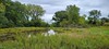


The above images may not be of the site on this page, but were taken nearby. They are loaded from Flickr so please click on them for image credits.
Click here to see more info for this site
Nearby sites
Click here to view sites on an interactive map of the areaKey: Red: member's photo, Blue: 3rd party photo, Yellow: other image, Green: no photo - please go there and take one, Grey: site destroyed
Download sites to:
KML (Google Earth)
GPX (GPS waypoints)
CSV (Garmin/Navman)
CSV (Excel)
To unlock full downloads you need to sign up as a Contributory Member. Otherwise downloads are limited to 50 sites.
Turn off the page maps and other distractions
Nearby sites listing. In the following links * = Image available
44.9km E 91° Lizard Mound State Park* Artificial Mound
47.4km SSW 197° Aztalan State Park* Ancient Village or Settlement
63.8km SE 144° Cutler Mound Group* Artificial Mound
68.5km SSW 193° The Finch Site Ancient Village or Settlement
68.8km SSW 195° Lake Koshkonong Mounds* Artificial Mound
75.1km SW 233° Forest Hill Cemetery* Artificial Mound
78.8km W 272° Man Mound Park* Artificial Mound
82.4km W 266° Devil's Lake Mounds* Artificial Mound
105.4km WSW 245° Circle Sanctuary Nature Preserve* Modern Stone Circle etc
107.0km WSW 246° Brighid's Spring at Circle Sanctuary* Holy Well or Sacred Spring
110.2km SE 139° Mound Cemetery (Racine) Barrow Cemetery
111.4km SSW 194° Beloit College Mounds* Artificial Mound
134.0km NW 305° Cranberry Creek Mound Group Artificial Mound
137.2km SSW 194° Beattie Park Mound Group* Misc. Earthwork
166.4km W 267° Tainter Cave Cave or Rock Shelter
171.3km WNW 291° Fort McCoy Artificial Mound
191.0km W 260° Larsen Cave, Crawford Co* Rock Art
192.3km SW 236° Dunleith Mounds* Artificial Mound
199.3km SSE 153° The Field Museum* Museum
202.4km SSW 203° Sinnissippi Mounds* Artificial Mound
203.5km WSW 255° Wyalusing Mounds* Artificial Mound
206.0km W 259° Effigy Mounds National Monument* Artificial Mound
207.7km SSE 154° University of Chicago Institute* Museum
208.5km W 270° Fish Farm Mounds State Preserve Artificial Mound
218.0km NNE 29° Chambers Island Mounds* Artificial Mound
View more nearby sites and additional images


 We would like to know more about this location. Please feel free to add a brief description and any relevant information in your own language.
 Wir möchten mehr über diese Stätte erfahren. Bitte zögern Sie nicht, eine kurze Beschreibung und relevante Informationen in Deutsch hinzuzufügen.
 Nous aimerions en savoir encore un peu sur les lieux. S'il vous plaît n'hesitez pas à ajouter une courte description et tous les renseignements pertinents dans votre propre langue.
 Quisieramos informarnos un poco más de las lugares. No dude en añadir una breve descripción y otros datos relevantes en su propio idioma.