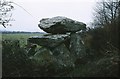
<< Our Photo Pages >> Knockeen Portal Tomb - Portal Tomb in Ireland (Republic of) in Co. Waterford
Submitted by durhamnature on Saturday, 20 October 2012 Page Views: 2871
Neolithic and Bronze AgeSite Name: Knockeen Portal TombCountry: Ireland (Republic of)
NOTE: This site is 10.601 km away from the location you searched for.
County: Co. Waterford Type: Portal Tomb
Map Ref: S575065
Latitude: 52.207763N Longitude: 7.159611W
Condition:
| 5 | Perfect |
| 4 | Almost Perfect |
| 3 | Reasonable but with some damage |
| 2 | Ruined but still recognisable as an ancient site |
| 1 | Pretty much destroyed, possibly visible as crop marks |
| 0 | No data. |
| -1 | Completely destroyed |
| 5 | Superb |
| 4 | Good |
| 3 | Ordinary |
| 2 | Not Good |
| 1 | Awful |
| 0 | No data. |
| 5 | Can be driven to, probably with disabled access |
| 4 | Short walk on a footpath |
| 3 | Requiring a bit more of a walk |
| 2 | A long walk |
| 1 | In the middle of nowhere, a nightmare to find |
| 0 | No data. |
| 5 | co-ordinates taken by GPS or official recorded co-ordinates |
| 4 | co-ordinates scaled from a detailed map |
| 3 | co-ordinates scaled from a bad map |
| 2 | co-ordinates of the nearest village |
| 1 | co-ordinates of the nearest town |
| 0 | no data |
Internal Links:
External Links:
")
A very attractive site, well preserved portal tomb.
You may be viewing yesterday's version of this page. To see the most up to date information please register for a free account.
")
")
")
Do not use the above information on other web sites or publications without permission of the contributor.
Nearby Images from Geograph Britain and Ireland:
©2008(licence)
©2009(licence)
©2009(licence)
©2009(licence)
©2009(licence)
The above images may not be of the site on this page, they are loaded from Geograph.
Please Submit an Image of this site or go out and take one for us!
Click here to see more info for this site
Nearby sites
Click here to view sites on an interactive map of the areaKey: Red: member's photo, Blue: 3rd party photo, Yellow: other image, Green: no photo - please go there and take one, Grey: site destroyed
Download sites to:
KML (Google Earth)
GPX (GPS waypoints)
CSV (Garmin/Navman)
CSV (Excel)
To unlock full downloads you need to sign up as a Contributory Member. Otherwise downloads are limited to 50 sites.
Turn off the page maps and other distractions
Nearby sites listing. In the following links * = Image available
3.5km W 266° Gaulstown Portal Dolmen* Burial Chamber or Dolmen
6.0km SW 232° Matthewstown* Passage Grave (S528028)
8.7km WSW 247° Ballinageeragh* Portal Tomb
9.7km SE 140° Coolum Promontory Stone Fort or Dun
10.5km ESE 104° Harristown* Passage Grave (S677040)
17.8km ESE 115° Duffin's Well Holy Well or Sacred Spring (X738993)
18.4km NE 48° Whitechurch Stone Circle (S710190)
18.4km NE 48° Whitechurch Stone Row / Alignment
19.0km NE 46° Whitechurch Standing Stone Standing Stone (Menhir)
20.1km NW 306° Ballyquin* Portal Tomb (S411182)
21.3km N 9° Three Friars* Stone Row / Alignment
21.4km WSW 257° Drumlohan* Standing Stone (Menhir) (S367013)
22.8km NNW 342° Kilmogue portal tomb* Portal Tomb
22.8km NNW 342° Kilmogue standing stone Standing Stone (Menhir)
24.1km NNE 31° Glencloghlea* Portal Tomb (S698273)
26.2km NNW 327° Baunfree* Passage Grave
27.8km NW 325° The Cross of Ages (Kilclispeen)* Ancient Cross (S413291)
29.5km ENE 60° Newbawn Portal Tomb
29.8km NNW 327° Knockroe* Passage Grave (S40863126)
30.0km NE 55° Carrickbyrne Stone Circle (S820240)
32.5km NE 47° Robinstown Great* Stone Circle (S8104629049)
33.3km W 280° Tooreen W Stone Row / Alignment (S245117)
33.9km N 359° St Nicholas's Grave (Newtown Jerpoint) Early Christian Sculptured Stone (S56794042)
34.9km W 277° Comeraghglin NE Stone Circle (S227105)
34.9km W 279° Carrigeen Standing Stone (Menhir) (S228113)
View more nearby sites and additional images


 We would like to know more about this location. Please feel free to add a brief description and any relevant information in your own language.
 Wir möchten mehr über diese Stätte erfahren. Bitte zögern Sie nicht, eine kurze Beschreibung und relevante Informationen in Deutsch hinzuzufügen.
 Nous aimerions en savoir encore un peu sur les lieux. S'il vous plaît n'hesitez pas à ajouter une courte description et tous les renseignements pertinents dans votre propre langue.
 Quisieramos informarnos un poco más de las lugares. No dude en añadir una breve descripción y otros datos relevantes en su propio idioma.