


<< Our Photo Pages >> The Cross of Ages (Kilclispeen) - Ancient Cross in Ireland (Republic of) in Co. Tipperary
Submitted by Sunny100 on Tuesday, 07 September 2010 Page Views: 6076
Early Medieval (Dark Age)Site Name: The Cross of Ages (Kilclispeen) Alternative Name: The Ahenny Cross, Kilclispeen High CrossCountry: Ireland (Republic of) County: Co. Tipperary Type: Ancient Cross
Nearest Town: Carrick-On-Suir Nearest Village: Ahenny
Map Ref: S413291
Latitude: 52.412298N Longitude: 7.3938W
Condition:
| 5 | Perfect |
| 4 | Almost Perfect |
| 3 | Reasonable but with some damage |
| 2 | Ruined but still recognisable as an ancient site |
| 1 | Pretty much destroyed, possibly visible as crop marks |
| 0 | No data. |
| -1 | Completely destroyed |
| 5 | Superb |
| 4 | Good |
| 3 | Ordinary |
| 2 | Not Good |
| 1 | Awful |
| 0 | No data. |
| 5 | Can be driven to, probably with disabled access |
| 4 | Short walk on a footpath |
| 3 | Requiring a bit more of a walk |
| 2 | A long walk |
| 1 | In the middle of nowhere, a nightmare to find |
| 0 | No data. |
| 5 | co-ordinates taken by GPS or official recorded co-ordinates |
| 4 | co-ordinates scaled from a detailed map |
| 3 | co-ordinates scaled from a bad map |
| 2 | co-ordinates of the nearest village |
| 1 | co-ordinates of the nearest town |
| 0 | no data |
Internal Links:
External Links:
 (PID:65062)")
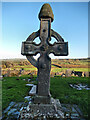
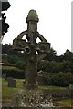
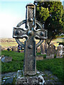
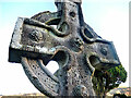
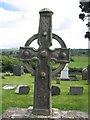
The Cross of Ages stands at the monastic site of Kilclispeen (Ahenny) a few miles N of Carrick-on-Suir.
The site dates back to the 5th-7th century and may have been founded by an unknown St Crispen. There are two 8th century high crosses and the base of a third cross.
The North Cross (illustrated) is 4 metres tall and made of sandstone. It is a richly carved ring/wheel cross of the 8th century CE and, along with the S cross, it is said to be one the finest of the Irish high crosses. The carvings include spirals, knotwork, braiding, and on it's base panels depicting biblical scenes. In one of the panels seven bishops from Rome are shown. They were apparently murdered by robbers thinking their purses held money. The stone cap (mitre) on top of the cross is removable. This was said to cure headaches if placed on the head. One of the wheel sections of the cross-head is missing. There are 5 bosses or studs on the cross-head which apparently imitate earlier wooden crosses.
The South Cross is very similar. Also dating from the 8th-9th century, this 4 metre tall sandstone high cross has a ring-head that is intact; the carvings being very similar to the N cross. There is also the base of a third cross at this monastic site. This was said to have been the most beautiful of the three, but 200 years ago it was stolen and then lost to the sea. Local legend says the rest of the cross still lies on the seabed off the Waterford coast.
You may be viewing yesterday's version of this page. To see the most up to date information please register for a free account.
 (PID:100140)")
Do not use the above information on other web sites or publications without permission of the contributor.
Nearby Images from Geograph Britain and Ireland:
©2021(licence)
©2020(licence)
©2021(licence)
©2021(licence)
©2007(licence)
The above images may not be of the site on this page, they are loaded from Geograph.
Please Submit an Image of this site or go out and take one for us!
Click here to see more info for this site
Nearby sites
Click here to view sites on an interactive map of the areaKey: Red: member's photo, Blue: 3rd party photo, Yellow: other image, Green: no photo - please go there and take one, Grey: site destroyed
Download sites to:
KML (Google Earth)
GPX (GPS waypoints)
CSV (Garmin/Navman)
CSV (Excel)
To unlock full downloads you need to sign up as a Contributory Member. Otherwise downloads are limited to 50 sites.
Turn off the page maps and other distractions
Nearby sites listing. In the following links * = Image available
1.9km ESE 115° Baunfree* Passage Grave
2.2km N 349° Knockroe* Passage Grave (S40863126)
7.9km NNW 333° Killamery High Cross Ancient Cross (S377361)
8.9km E 97° Kilmogue standing stone Standing Stone (Menhir)
9.0km E 96° Kilmogue portal tomb* Portal Tomb
10.9km S 182° Ballyquin* Portal Tomb (S411182)
14.5km NE 36° Kilree Monastery* Ancient Cross
19.1km NE 54° St Nicholas's Grave (Newtown Jerpoint) Early Christian Sculptured Stone (S56794042)
19.3km E 95° Three Friars* Stone Row / Alignment
24.1km SW 224° Tooreen W Stone Row / Alignment (S245117)
24.8km WSW 256° St Patrick's Holy Well (Clonmel) Holy Well or Sacred Spring (S173227)
25.6km SW 227° Carrigeen Standing Stone (Menhir) (S228113)
25.6km SW 227° Knockanaffrin* Standing Stones (S227114)
25.9km SW 227° Kilkeany Stone Circle (S225112)
26.1km SSE 151° Gaulstown Portal Dolmen* Burial Chamber or Dolmen
26.3km SW 225° Comeraghglin NE Stone Circle (S227105)
26.4km SW 225° Comeraghglin SW* Stone Circle (S226104)
27.3km SSE 163° Ballinageeragh* Portal Tomb
27.8km SE 145° Knockeen Portal Tomb* Portal Tomb (S575065)
28.2km S 190° Drumlohan* Standing Stone (Menhir) (S367013)
28.5km E 94° Glencloghlea* Portal Tomb (S698273)
28.7km SSE 157° Matthewstown* Passage Grave (S528028)
29.7km ENE 69° Brandon Hill Stone Circle (S690400)
31.0km ESE 108° Whitechurch Standing Stone Standing Stone (Menhir)
31.3km ESE 109° Whitechurch Stone Circle (S710190)
View more nearby sites and additional images


 We would like to know more about this location. Please feel free to add a brief description and any relevant information in your own language.
 Wir möchten mehr über diese Stätte erfahren. Bitte zögern Sie nicht, eine kurze Beschreibung und relevante Informationen in Deutsch hinzuzufügen.
 Nous aimerions en savoir encore un peu sur les lieux. S'il vous plaît n'hesitez pas à ajouter une courte description et tous les renseignements pertinents dans votre propre langue.
 Quisieramos informarnos un poco más de las lugares. No dude en añadir una breve descripción y otros datos relevantes en su propio idioma.