<< Our Photo Pages >> Port au Choix National Historic Site - Ancient Village or Settlement in Canada
Submitted by MartinJEley on Sunday, 26 July 2015 Page Views: 5348
Multi-periodSite Name: Port au Choix National Historic SiteCountry: Canada
NOTE: This site is 468.684 km away from the location you searched for.
Type: Ancient Village or Settlement
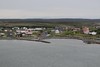
Nearest Town: Port au Choix
Latitude: 50.697020N Longitude: 57.38181W
Condition:
| 5 | Perfect |
| 4 | Almost Perfect |
| 3 | Reasonable but with some damage |
| 2 | Ruined but still recognisable as an ancient site |
| 1 | Pretty much destroyed, possibly visible as crop marks |
| 0 | No data. |
| -1 | Completely destroyed |
| 5 | Superb |
| 4 | Good |
| 3 | Ordinary |
| 2 | Not Good |
| 1 | Awful |
| 0 | No data. |
| 5 | Can be driven to, probably with disabled access |
| 4 | Short walk on a footpath |
| 3 | Requiring a bit more of a walk |
| 2 | A long walk |
| 1 | In the middle of nowhere, a nightmare to find |
| 0 | No data. |
| 5 | co-ordinates taken by GPS or official recorded co-ordinates |
| 4 | co-ordinates scaled from a detailed map |
| 3 | co-ordinates scaled from a bad map |
| 2 | co-ordinates of the nearest village |
| 1 | co-ordinates of the nearest town |
| 0 | no data |
Internal Links:
External Links:
I have visited· I would like to visit
rrmoser would like to visit
MartinJEley visited on 18th Jun 2015 - their rating: Cond: 1 Amb: 3 Access: 5 Although there is little to see in the way of ruins appreciating the remoteness of the site and its long history make a visit worthwhile.
")
The archaeology goes well beyond this site with elements being found at many sites across Newfoundland's Great Northern Penninsula. The site is operated by Parks Canada. The site has been developed to provide visitors with an insight into the history of the site while exploring both natural and man made features.
Located off the main site, in the nearby town of Port au Choix, is the site of the Maritime Archaic Indian Cemetery with a modern Gathering Circle, and interpretative panels. A small museum at the same location also provides valuable historical information. A visit to this area provides a tremendous insight into the long history of this area of Newfoundland.
You may be viewing yesterday's version of this page. To see the most up to date information please register for a free account.
")
")
Do not use the above information on other web sites or publications without permission of the contributor.
Nearby Images from Flickr

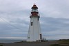
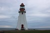
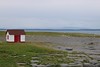
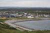
The above images may not be of the site on this page, but were taken nearby. They are loaded from Flickr so please click on them for image credits.
Click here to see more info for this site
Nearby sites
Click here to view sites on an interactive map of the areaKey: Red: member's photo, Blue: 3rd party photo, Yellow: other image, Green: no photo - please go there and take one, Grey: site destroyed
Download sites to:
KML (Google Earth)
GPX (GPS waypoints)
CSV (Garmin/Navman)
CSV (Excel)
To unlock full downloads you need to sign up as a Contributory Member. Otherwise downloads are limited to 50 sites.
Turn off the page maps and other distractions
Nearby sites listing. In the following links * = Image available
163.2km NE 52° L'Anse aux Meadows National Historic Site* Ancient Village or Settlement
558.7km SSW 207° Big Hill Dolmen Burial Chamber or Dolmen
597.3km SSW 205° Loch Lomond Circle Modern Stone Circle etc
745.0km WSW 239° Augustine Mound Round Barrow(s)
798.0km SW 217° Sibley Rock Burial Chamber or Dolmen
812.8km SW 218° Admirals Park Dolmen Burial Chamber or Dolmen
822.9km SW 217° Kidston Lake Dolmen Burial Chamber or Dolmen
824.6km SW 217° Roachs Pond Dolmen Burial Chamber or Dolmen
860.1km SW 220° Stone Arrangements on Oak Island Modern Stone Circle etc
999.8km SW 232° Machias Bay Petroglyphs Rock Art
1100.0km WSW 252° Quebec ice dolmen* Modern Stone Circle etc
1298.8km WSW 246° Balancing Stone Westfield Natural Stone / Erratic / Other Natural Feature
1323.8km WSW 245° Elmore Balancing Rock* Natural Stone / Erratic / Other Natural Feature
1328.3km WSW 251° Charles De Gaulle Obelisk* Modern Stone Circle etc
1341.4km WSW 236° Pawtuckaway Balancing Rock* Natural Stone / Erratic / Other Natural Feature
1364.4km SW 236° America's Stonehenge* Ancient Village or Settlement
1365.8km WSW 241° Humming Stone Norwich (Summstein) Modern Stone Circle etc
1366.3km WSW 239° Mount Kearsarge Indian Museum Museum
1375.0km WSW 248° Earthwood Modern Stone Circle Modern Stone Circle etc
1378.2km SW 229° Fort Hill Sharpening Stone* Polissoir
1389.6km WSW 241° Calendar II* Artificial Mound
1400.9km WSW 249° Earthwood new stone circle Modern Stone Circle etc
1406.5km SW 233° Mary Caroline Herter Public Garden Modern Stone Circle etc
1415.2km WSW 239° Bellows Falls Petroglyphs* Rock Art
1430.7km SW 236° Wachusett Stone* Natural Stone / Erratic / Other Natural Feature
View more nearby sites and additional images


 We would like to know more about this location. Please feel free to add a brief description and any relevant information in your own language.
 Wir möchten mehr über diese Stätte erfahren. Bitte zögern Sie nicht, eine kurze Beschreibung und relevante Informationen in Deutsch hinzuzufügen.
 Nous aimerions en savoir encore un peu sur les lieux. S'il vous plaît n'hesitez pas à ajouter une courte description et tous les renseignements pertinents dans votre propre langue.
 Quisieramos informarnos un poco más de las lugares. No dude en añadir una breve descripción y otros datos relevantes en su propio idioma.