<< Our Photo Pages >> Killivose Cross - Ancient Cross in England in Cornwall
Submitted by Bladup on Saturday, 29 August 2020 Page Views: 689
Early Medieval (Dark Age)Site Name: Killivose CrossCountry: England
NOTE: This site is 0.933 km away from the location you searched for.
County: Cornwall Type: Ancient Cross
Map Ref: SW64683995
Latitude: 50.212655N Longitude: 5.299667W
Condition:
| 5 | Perfect |
| 4 | Almost Perfect |
| 3 | Reasonable but with some damage |
| 2 | Ruined but still recognisable as an ancient site |
| 1 | Pretty much destroyed, possibly visible as crop marks |
| 0 | No data. |
| -1 | Completely destroyed |
| 5 | Superb |
| 4 | Good |
| 3 | Ordinary |
| 2 | Not Good |
| 1 | Awful |
| 0 | No data. |
| 5 | Can be driven to, probably with disabled access |
| 4 | Short walk on a footpath |
| 3 | Requiring a bit more of a walk |
| 2 | A long walk |
| 1 | In the middle of nowhere, a nightmare to find |
| 0 | No data. |
| 5 | co-ordinates taken by GPS or official recorded co-ordinates |
| 4 | co-ordinates scaled from a detailed map |
| 3 | co-ordinates scaled from a bad map |
| 2 | co-ordinates of the nearest village |
| 1 | co-ordinates of the nearest town |
| 0 | no data |
Internal Links:
External Links:
I have visited· I would like to visit
hallsifer visited on 31st Jan 2022 - their rating: Cond: 3 Amb: 3 Access: 5 Easy to find right outside the Wesleyan Chapel, some road parking.
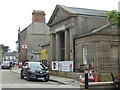
LiveAndrew visited on 18th Mar 2021 - their rating: Cond: 3 Amb: 2 Access: 5 Not a particularly nice position as it's very close to a busy, town centre. Hard to photograph one side as it's quite close to a railing.
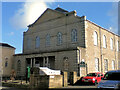
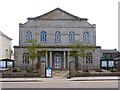
Very easy to find. Head onto Trelowarren Street, Camborne's main, one-way, shopping street (limited on-street parking but there's a large car park very nearby). Near the top end there is a small square with a Bingo hall, benches, etc. Go through the square, following Chapel Street, the road perpendicular to the shopping street. The cross is in front of the Methodist chapel, a hundred or so metres on the left-hand side of the street. Earlier on this street, on the right-hand side, is the Camborne Cross.
I recommend parking in the Rosewarne car park for an hour, walking back up to Trelowarren Street. It's then pretty easy to visit the Camborne Cross and Killivose Cross, then walking up Trelowarren Street, across the roundabout to the Church of St Martin & St Meriadoc and then visiting Maen Cadoar menhir/Cross and Ia's Cross (not currently on this site).
lucasn visited - their rating: Cond: 4 Amb: 3 Access: 5
Average ratings for this site from all visit loggers: Condition: 3.33 Ambience: 2.67 Access: 5
")
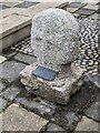
A wheel-head cross was once in the garden of 4 Beacon Terrace (SW 653394) Camborne, having been brought there from a garden at Trevu. It had been found in 1883 at the junction of Kitty's Lane, (now Killivose Road), and the lane from Killivose to Beacon (SW 64793909) by a gardener at Trevu.
It was again moved to the forecourt of the Wesleyan Chapel in Chapel Street, Camborne and
positioned at SW 64683995, Which is where it is now to be found
You may be viewing yesterday's version of this page. To see the most up to date information please register for a free account.
")
")
")
Do not use the above information on other web sites or publications without permission of the contributor.
Nearby Images from Geograph Britain and Ireland:
©2022(licence)
©2023(licence)
©2013(licence)
©2006(licence)
©2018(licence)
The above images may not be of the site on this page, they are loaded from Geograph.
Please Submit an Image of this site or go out and take one for us!
Click here to see more info for this site
Nearby sites
Key: Red: member's photo, Blue: 3rd party photo, Yellow: other image, Green: no photo - please go there and take one, Grey: site destroyed
Download sites to:
KML (Google Earth)
GPX (GPS waypoints)
CSV (Garmin/Navman)
CSV (Excel)
To unlock full downloads you need to sign up as a Contributory Member. Otherwise downloads are limited to 50 sites.
Turn off the page maps and other distractions
Nearby sites listing. In the following links * = Image available
102m N 9° Camborne Cross* Ancient Cross (SW64704005)
178m WNW 294° St Martin and St Meriadoc Cross Ancient Cross (SW64524003)
193m WNW 289° St Ia's Cross* Ancient Cross (SW64504002)
234m NW 307° Maen Cadoar* Standing Stone (Menhir) (SW645401)
531m N 354° St Meriasek's Well* Holy Well or Sacred Spring (SW6464640480)
1.6km SSE 166° The Rocks* Rock Outcrop (SW650384)
2.0km SE 143° St Ia's Well (Troon)* Holy Well or Sacred Spring (SW658383)
2.1km WSW 240° The Hood* Ancient Village or Settlement (SW62823899)
2.2km SSE 167° Treslothan Cross* Ancient Cross (SW65073781)
2.2km SSE 166° Treslothan Holy Well* Holy Well or Sacred Spring (SW651378)
2.5km NE 47° Camborne School of Mines Geological Museum Museum (SW666416)
2.8km S 171° Carwynnen Quoit* Portal Tomb (SW65013721)
2.8km E 92° Canarthen Cross* Ancient Cross (SW67453973)
2.8km SSE 167° Hr Carwynnen* Stone Circle (SW652372)
3.0km E 83° Bosleake Stones* Modern Stone Circle etc (SW67674018)
3.1km SW 224° Penhale Tumulus Round Barrow(s) (SW62423785)
3.6km SSE 158° Carwymen Settlement Ancient Village or Settlement (SW65903656)
3.7km ESE 123° Vincent's Well Holy Well or Sacred Spring (SW677378)
3.7km WNW 286° Trevorian Round Ancient Village or Settlement (SW61154110)
3.8km N 352° Tehidy round* Ancient Village or Settlement (SW643437)
3.9km ENE 76° Carn Brea Enclosure* Ancient Village or Settlement (SW685407)
4.0km ENE 74° Carn Brea Well* Holy Well or Sacred Spring (SW68584085)
4.1km ENE 77° Menhir Carn Brea (Redruth)* Standing Stone (Menhir) (SW687407)
4.1km NNE 23° Mary's Well (Illogan)* Holy Well or Sacred Spring (SW66484369)
4.2km NNW 341° Crane Castle* Promontory Fort / Cliff Castle (SW635440)
View more nearby sites and additional images


 We would like to know more about this location. Please feel free to add a brief description and any relevant information in your own language.
 Wir möchten mehr über diese Stätte erfahren. Bitte zögern Sie nicht, eine kurze Beschreibung und relevante Informationen in Deutsch hinzuzufügen.
 Nous aimerions en savoir encore un peu sur les lieux. S'il vous plaît n'hesitez pas à ajouter une courte description et tous les renseignements pertinents dans votre propre langue.
 Quisieramos informarnos un poco más de las lugares. No dude en añadir una breve descripción y otros datos relevantes en su propio idioma.