


<< Other Photo Pages >> Cherry Island - Crannog in Scotland in Highlands
Submitted by KaiHofmann on Wednesday, 22 April 2015 Page Views: 3294
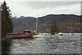
Iron Age and Later PrehistorySite Name: Cherry IslandCountry: Scotland
NOTE: This site is 12.836 km away from the location you searched for.
County: Highlands Type: Crannog
Nearest Town: Inverness Nearest Village: Fort Augustus
Map Ref: NH385102
Latitude: 57.154173N Longitude: 4.671533W
Condition:
| 5 | Perfect |
| 4 | Almost Perfect |
| 3 | Reasonable but with some damage |
| 2 | Ruined but still recognisable as an ancient site |
| 1 | Pretty much destroyed, possibly visible as crop marks |
| 0 | No data. |
| -1 | Completely destroyed |
| 5 | Superb |
| 4 | Good |
| 3 | Ordinary |
| 2 | Not Good |
| 1 | Awful |
| 0 | No data. |
| 5 | Can be driven to, probably with disabled access |
| 4 | Short walk on a footpath |
| 3 | Requiring a bit more of a walk |
| 2 | A long walk |
| 1 | In the middle of nowhere, a nightmare to find |
| 0 | No data. |
| 5 | co-ordinates taken by GPS or official recorded co-ordinates |
| 4 | co-ordinates scaled from a detailed map |
| 3 | co-ordinates scaled from a bad map |
| 2 | co-ordinates of the nearest village |
| 1 | co-ordinates of the nearest town |
| 0 | no data |
Internal Links:
External Links:
")
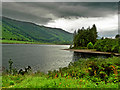
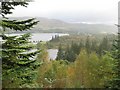
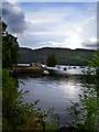
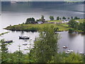
A bronze-age crannog in the south-western part of Loch Ness.
You may be viewing yesterday's version of this page. To see the most up to date information please register for a free account.
")
")
Do not use the above information on other web sites or publications without permission of the contributor.
Nearby Images from Geograph Britain and Ireland:
©2009(licence)
©2007(licence)
©2009(licence)
©2008(licence)
©2008(licence)
The above images may not be of the site on this page, they are loaded from Geograph.
Please Submit an Image of this site or go out and take one for us!
Click here to see more info for this site
Nearby sites
Key: Red: member's photo, Blue: 3rd party photo, Yellow: other image, Green: no photo - please go there and take one, Grey: site destroyed
Download sites to:
KML (Google Earth)
GPX (GPS waypoints)
CSV (Garmin/Navman)
CSV (Excel)
To unlock full downloads you need to sign up as a Contributory Member. Otherwise downloads are limited to 50 sites.
Turn off the page maps and other distractions
Nearby sites listing. In the following links * = Image available
13.3km NNE 30° Boulder near Creag Dhearg Natural Stone / Erratic / Other Natural Feature (NH456215)
13.6km SSW 214° Well of the Heads* Holy Well or Sacred Spring (NN3047399140)
14.0km SW 236° Cill Donnain* Early Christian Sculptured Stone (NH26580276)
19.9km N 355° Mony's Stone* Standing Stone (Menhir) (NH3751530072)
20.1km N 357° Corrimony* Clava Cairn (NH38303029)
20.2km N 357° Corrimony mound Artificial Mound (NH38383038)
20.8km N 358° Curadan's Well* Holy Well or Sacred Spring (NH38753102)
20.8km N 1° Buntait Cup Marked Stone* Rock Art (NH39793102)
21.6km NNW 342° Comar Wood* Stone Fort or Dun (NH3250931008)
23.9km NNE 25° Clachmhor, Culnakirk* Rock Art (NH49443145)
23.9km NNE 25° Carn Daley* Clava Cairn (NH4945431458)
24.5km NE 34° Holy Well (Drumnadrochit)* Holy Well or Sacred Spring (NH530300)
24.6km N 354° St Ignatius' Well* Holy Well or Sacred Spring (NH3709934761)
26.2km SE 129° Dun da Lamh* Stone Fort or Dun (NN582929)
27.0km SSW 197° Glen Roy Chalice Stone* Rock Art (NN295847)
29.5km N 360° Dun Coille Struy Broch or Nuraghe (NH39643976)
30.6km NE 55° Dhuallow Clava Cairn (NH644267)
31.1km ESE 108° Glenbanchor Cairn (NN678994)
31.2km NNE 18° Boblainy* Stone Circle (NH49343951)
32.0km ESE 106° Sidhean Mor Dail A' Chaorainn* Hillfort (NH69060039)
32.5km NE 44° West Town* Chambered Cairn (NH62173258)
32.5km SSW 204° Killichonate Well* Holy Well or Sacred Spring (NN241810)
33.2km NNE 22° Allt Eoghainn* Chambered Tomb (NH5236240392)
33.2km NNE 18° Bruiach* Cairn (NH49984143)
33.3km NNE 16° Culburnie* Stone Circle (NH491418)
View more nearby sites and additional images


 We would like to know more about this location. Please feel free to add a brief description and any relevant information in your own language.
 Wir möchten mehr über diese Stätte erfahren. Bitte zögern Sie nicht, eine kurze Beschreibung und relevante Informationen in Deutsch hinzuzufügen.
 Nous aimerions en savoir encore un peu sur les lieux. S'il vous plaît n'hesitez pas à ajouter une courte description et tous les renseignements pertinents dans votre propre langue.
 Quisieramos informarnos un poco más de las lugares. No dude en añadir una breve descripción y otros datos relevantes en su propio idioma.