<< Other Photo Pages >> Strath Tollidh - Broch or Nuraghe in Scotland in Caithness
Submitted by Andy B on Wednesday, 21 April 2010 Page Views: 2878
Iron Age and Later PrehistorySite Name: Strath TollidhCountry: Scotland
NOTE: This site is 4.703 km away from the location you searched for.
County: Caithness Type: Broch or Nuraghe
Map Ref: NH705990
Latitude: 57.961387N Longitude: 4.190351W
Condition:
| 5 | Perfect |
| 4 | Almost Perfect |
| 3 | Reasonable but with some damage |
| 2 | Ruined but still recognisable as an ancient site |
| 1 | Pretty much destroyed, possibly visible as crop marks |
| 0 | No data. |
| -1 | Completely destroyed |
| 5 | Superb |
| 4 | Good |
| 3 | Ordinary |
| 2 | Not Good |
| 1 | Awful |
| 0 | No data. |
| 5 | Can be driven to, probably with disabled access |
| 4 | Short walk on a footpath |
| 3 | Requiring a bit more of a walk |
| 2 | A long walk |
| 1 | In the middle of nowhere, a nightmare to find |
| 0 | No data. |
| 5 | co-ordinates taken by GPS or official recorded co-ordinates |
| 4 | co-ordinates scaled from a detailed map |
| 3 | co-ordinates scaled from a bad map |
| 2 | co-ordinates of the nearest village |
| 1 | co-ordinates of the nearest town |
| 0 | no data |
Internal Links:
External Links:
I have visited· I would like to visit
Andy B has visited here
")
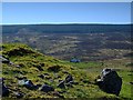
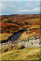
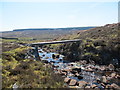
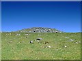
The two straths meet here, Strath Carnaig and Strath Tollidh.
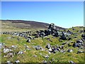
Not much left of the Broch but I am sure that the stone would have been used in the surrounding dry stane wall.
You may be viewing yesterday's version of this page. To see the most up to date information please register for a free account.
")
")
Do not use the above information on other web sites or publications without permission of the contributor.
Nearby Images from Geograph Britain and Ireland:
©2007(licence)
©2007(licence)
©2011(licence)
©2012(licence)
©2007(licence)
The above images may not be of the site on this page, they are loaded from Geograph.
Please Submit an Image of this site or go out and take one for us!
Click here to see more info for this site
Nearby sites
Key: Red: member's photo, Blue: 3rd party photo, Yellow: other image, Green: no photo - please go there and take one, Grey: site destroyed
Download sites to:
KML (Google Earth)
GPX (GPS waypoints)
CSV (Garmin/Navman)
CSV (Excel)
To unlock full downloads you need to sign up as a Contributory Member. Otherwise downloads are limited to 50 sites.
Turn off the page maps and other distractions
Nearby sites listing. In the following links * = Image available
3.6km E 81° Carn Liath (Dornoch) Chambered Cairn (NH74119945)
4.5km E 88° Thor's Tower Broch or Nuraghe (NH7599)
6.4km E 87° Aberscross* Stone Circle (NH7690399077)
6.6km NNE 23° Achnagarron Stones Standing Stones (NC7329804978)
8.6km SSW 201° Achaidh Chambered Cairn* Chambered Cairn (NH671911)
8.9km ESE 119° Skelbo Wood Broch or Nuraghe (NH78209443)
9.0km SSW 207° Kyleoag Chambered Cairn Chambered Cairn (NH662911)
9.2km SSW 199° Cairn, Fairy Glen, Bailenacile Cairn (NH672904)
9.2km SSW 199° Allt nan Eun Chambered Cairn Chambered Cairn (NH672904)
9.4km E 90° St. Carden's Chapel Class I Pictish Symbol Stone (NH79939870)
9.5km NW 306° Allt Na Meirle Broch or Nuraghe (NC63000484)
9.6km S 171° Clach a' Charra* Standing Stone (Menhir) (NH7164789493)
10.0km N 349° West Langwell Ancient Village or Settlement (NC68880888)
10.2km N 352° West Langwell Cairns Cairn (NC69410917)
10.3km N 351° West Langwell Hut Circle Ancient Village or Settlement (NC69300921)
10.3km N 351° Lang Well Holy Well or Sacred Spring (NC69300921)
10.9km SW 226° Loch Migdale Henge (NH62429160)
11.4km N 10° Cnoc An Liath-Bhaid* Stone Circle (NC728102)
11.8km S 189° Ardvannie* Chambered Cairn (NH68238740)
12.0km SSW 213° St Demhan's Cross* Early Christian Sculptured Stone (NH636892)
12.1km W 277° Auchinduich* Stone Circle (NC58450084)
13.0km WSW 258° Invershin Farm* Standing Stone (Menhir) (NH5760796742)
13.1km SSW 200° Dun Alascaig Broch or Nuraghe (NH65698682)
13.2km S 187° Lower Lechanich North Chambered Tomb (NH684859)
13.3km S 187° Lower Lechanich South Chambered Tomb (NH684858)
View more nearby sites and additional images


 We would like to know more about this location. Please feel free to add a brief description and any relevant information in your own language.
 Wir möchten mehr über diese Stätte erfahren. Bitte zögern Sie nicht, eine kurze Beschreibung und relevante Informationen in Deutsch hinzuzufügen.
 Nous aimerions en savoir encore un peu sur les lieux. S'il vous plaît n'hesitez pas à ajouter une courte description et tous les renseignements pertinents dans votre propre langue.
 Quisieramos informarnos un poco más de las lugares. No dude en añadir una breve descripción y otros datos relevantes en su propio idioma.