<< Our Photo Pages >> Nant Cnewr-Fawr Cairn - Cairn in Wales in Powys
Submitted by sem on Tuesday, 05 June 2012 Page Views: 2276
Neolithic and Bronze AgeSite Name: Nant Cnewr-Fawr CairnCountry: Wales
NOTE: This site is 2.368 km away from the location you searched for.
County: Powys Type: Cairn
Nearest Town: Sennybridge Nearest Village: Defynnog
Map Ref: SN9030022608
Latitude: 51.891195N Longitude: 3.595495W
Condition:
| 5 | Perfect |
| 4 | Almost Perfect |
| 3 | Reasonable but with some damage |
| 2 | Ruined but still recognisable as an ancient site |
| 1 | Pretty much destroyed, possibly visible as crop marks |
| 0 | No data. |
| -1 | Completely destroyed |
| 5 | Superb |
| 4 | Good |
| 3 | Ordinary |
| 2 | Not Good |
| 1 | Awful |
| 0 | No data. |
| 5 | Can be driven to, probably with disabled access |
| 4 | Short walk on a footpath |
| 3 | Requiring a bit more of a walk |
| 2 | A long walk |
| 1 | In the middle of nowhere, a nightmare to find |
| 0 | No data. |
| 5 | co-ordinates taken by GPS or official recorded co-ordinates |
| 4 | co-ordinates scaled from a detailed map |
| 3 | co-ordinates scaled from a bad map |
| 2 | co-ordinates of the nearest village |
| 1 | co-ordinates of the nearest town |
| 0 | no data |
Internal Links:
External Links:
I have visited· I would like to visit
sem has visited here
")
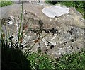
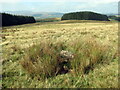
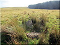
All that remains of this cairn is the cist. The stone has been robbed to build a nearby sheepfold in the shape of a "funky Celtic cross."
RCAHMW NPRN 84769.
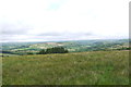
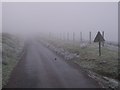
As with the nearby standing stone it is difficult to find, despite being close to a nearby road.
You may be viewing yesterday's version of this page. To see the most up to date information please register for a free account.
Do not use the above information on other web sites or publications without permission of the contributor.
Nearby Images from Geograph Britain and Ireland:
©2020(licence)
©2022(licence)
©2022(licence)
©2015(licence)
©2009(licence)
The above images may not be of the site on this page, they are loaded from Geograph.
Please Submit an Image of this site or go out and take one for us!
Click here to see more info for this site
Nearby sites
Key: Red: member's photo, Blue: 3rd party photo, Yellow: other image, Green: no photo - please go there and take one, Grey: site destroyed
Download sites to:
KML (Google Earth)
GPX (GPS waypoints)
CSV (Garmin/Navman)
CSV (Excel)
To unlock full downloads you need to sign up as a Contributory Member. Otherwise downloads are limited to 50 sites.
Turn off the page maps and other distractions
Nearby sites listing. In the following links * = Image available
181m SSE 166° Nant Cnewr-Fawr Stone* Standing Stone (Menhir) (SN9034122432)
3.9km SSE 163° Fan Nedd stone pillar* Cairn (SN91341883)
4.0km SSE 156° Fan Nedd Cairn* Cairn (SN9184618927)
4.0km SSE 147° Maen Llia* Standing Stone (Menhir) (SN9241719186)
4.1km SSE 148° Llech Llia Recumbent Monolith* Natural Stone / Erratic / Other Natural Feature (SN92381908)
4.1km SSE 147° Rhyd Uchaf Stone Alignment* Stone Row / Alignment (SN92451912)
4.1km NNE 26° Twyn-y-Gaer (Heol Senni) Hillfort (SN922263)
4.2km SSE 152° Maen Llia Barrow Round Barrow(s) (SN922189)
4.2km SSE 150° Llech Llia multi banked henge* Henge (SN92321896)
4.2km NNE 27° Twyn y Gaer (Defynnog)* Hillfort (SN92252630)
4.3km SE 146° Rhyd Uchaf cairn* Cairn (SN92641896)
4.6km WSW 243° Waun Leuci summit cairns* Cairn (SN8618320639)
4.6km W 270° Bwlch Cerrig Duon Cist east* Cairn (SN85682272)
4.7km W 266° Bwllch Cerrig Duon Barrow* Round Barrow(s) (SN85552235)
4.8km W 270° Bwlch Cerrig Duon Cist west* Cist (SN8553122708)
4.9km SE 145° Fan Llia Round Cairn (2)* Cairn (SN92971855)
4.9km NE 46° Tyle Bychan* Standing Stones (SN93872595)
5.0km WSW 256° Waen Llechi* Standing Stone (Menhir) (SN85462150)
5.2km WSW 257° Maen Leuci stone setting* Standing Stones (SN85202156)
5.2km E 99° Craig Cwn Ddu cairns* Cairn (SN95452170)
5.2km WSW 257° Tawe valley Triangle* Standing Stones (SN8516421530)
5.4km WSW 253° Waun Leuci Standing Stone* Standing Stone (Menhir) (SN8512021200)
5.5km SE 143° Fan Llia Summit Cairn* Cairn (SN9353218168)
5.5km WSW 248° Cerrig Duon Row* Multiple Stone Rows / Avenue (SN8515120642)
5.5km WSW 248° Maen Mawr* Stone Row / Alignment (SN85122064)
View more nearby sites and additional images


 We would like to know more about this location. Please feel free to add a brief description and any relevant information in your own language.
 Wir möchten mehr über diese Stätte erfahren. Bitte zögern Sie nicht, eine kurze Beschreibung und relevante Informationen in Deutsch hinzuzufügen.
 Nous aimerions en savoir encore un peu sur les lieux. S'il vous plaît n'hesitez pas à ajouter une courte description et tous les renseignements pertinents dans votre propre langue.
 Quisieramos informarnos un poco más de las lugares. No dude en añadir una breve descripción y otros datos relevantes en su propio idioma.