

<< Our Photo Pages >> Hare Law (Fife) - Cairn in Scotland in Fife
Submitted by cosmic on Saturday, 20 May 2006 Page Views: 10231
Neolithic and Bronze AgeSite Name: Hare Law (Fife)Country: Scotland County: Fife Type: Cairn
Nearest Village: Lochore
Map Ref: NT187961
Latitude: 56.150632N Longitude: 3.310242W
Condition:
| 5 | Perfect |
| 4 | Almost Perfect |
| 3 | Reasonable but with some damage |
| 2 | Ruined but still recognisable as an ancient site |
| 1 | Pretty much destroyed, possibly visible as crop marks |
| 0 | No data. |
| -1 | Completely destroyed |
| 5 | Superb |
| 4 | Good |
| 3 | Ordinary |
| 2 | Not Good |
| 1 | Awful |
| 0 | No data. |
| 5 | Can be driven to, probably with disabled access |
| 4 | Short walk on a footpath |
| 3 | Requiring a bit more of a walk |
| 2 | A long walk |
| 1 | In the middle of nowhere, a nightmare to find |
| 0 | No data. |
| 5 | co-ordinates taken by GPS or official recorded co-ordinates |
| 4 | co-ordinates scaled from a detailed map |
| 3 | co-ordinates scaled from a bad map |
| 2 | co-ordinates of the nearest village |
| 1 | co-ordinates of the nearest town |
| 0 | no data |
Internal Links:
External Links:
 (PID:20818)")
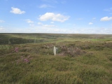
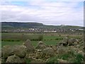
This cairn has suffered mutilation from Victorian excavators (see this pdf and this pdf).
But is noteworthy for the situation which has a wonderful 270 degree vista and the fact that the Victorians did find three cists and two complete urns - one of which was left in situ overnight so that people could view it but thrown aside and shattered by treasure hunters before the excavation was resumed.
You may be viewing yesterday's version of this page. To see the most up to date information please register for a free account.
 (PID:20819)")
 (PID:20817)")
 (PID:20816)")
Do not use the above information on other web sites or publications without permission of the contributor.
Nearby Images from Geograph Britain and Ireland:
©2008(licence)
©2006(licence)
©2014(licence)
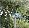
©2014(licence)
©2006(licence)
The above images may not be of the site on this page, they are loaded from Geograph.
Please Submit an Image of this site or go out and take one for us!
Click here to see more info for this site
Nearby sites
Key: Red: member's photo, Blue: 3rd party photo, Yellow: other image, Green: no photo - please go there and take one, Grey: site destroyed
Download sites to:
KML (Google Earth)
GPX (GPS waypoints)
CSV (Garmin/Navman)
CSV (Excel)
To unlock full downloads you need to sign up as a Contributory Member. Otherwise downloads are limited to 50 sites.
Turn off the page maps and other distractions
Nearby sites listing. In the following links * = Image available
1.0km WSW 252° Kirkhall, Lochore Stone Circle (NT177958)
5.0km E 80° Dogton* Class III Pictish Cross Slab (NT2360996863)
5.6km N 357° Scotlandwell* Holy Well or Sacred Spring (NO1847801656)
6.0km N 353° Kilmagadwood Early Bronze Age cemetery Barrow Cemetery (NO1805702119)
6.3km SSE 159° Auchertool Holy Well* Holy Well or Sacred Spring (NT208902)
6.9km NE 38° Strathhendry* Stone Circle (NO23050145)
6.9km WNW 291° Fairy Knowe (Gairneybank) Cairn (NT12309874)
7.1km SW 233° St Ninians Fife Earth Project* Modern Stone Circle etc (NT129919)
9.0km NNW 334° Orwell Standing Stones* Standing Stones (NO14940432)
9.6km SE 142° North Glassmount* Standing Stones (NT244884)
9.9km NW 324° Orwell Cursus Cursus (NO13010423)
10.1km SSE 155° Binn (Burntisland)* Rock Art (NT2278886891)
10.2km WNW 287° Craigton (Kinross) Cairn (NT090993)
10.7km S 175° St Fillan's Well (Aberdour)* Holy Well or Sacred Spring (NT194854)
10.9km E 94° Bogleys* Standing Stone (Menhir) (NT296951)
11.1km S 177° Aberdour Cairn Cairn (NT1985)
11.2km SSE 152° Craigkennockie (Burntisland) Cairn (NT237861)
11.5km SSW 199° St Theriot's Well* Holy Well or Sacred Spring (NT147853)
11.6km NNE 28° East Lomond Hill Hillfort (NO24400620)
11.8km NE 52° Balfarg Henge* Henge (NO2819803123)
11.9km S 183° Barns Farm Dalgety Fife* Barrow Cemetery (NT178842)
12.0km SSW 192° Fordell Standing Stone* Standing Stone (Menhir) (NT15938446)
12.0km NE 54° Balbirnie* Stone Circle (NO2858702969)
12.0km NE 53° Balfarg Riding School mortuary enclosure and henge* Henge (NO28480314)
12.0km NNE 16° Kilgour Class I Pictish Symbol Stone (NO223076)
View more nearby sites and additional images


 We would like to know more about this location. Please feel free to add a brief description and any relevant information in your own language.
 Wir möchten mehr über diese Stätte erfahren. Bitte zögern Sie nicht, eine kurze Beschreibung und relevante Informationen in Deutsch hinzuzufügen.
 Nous aimerions en savoir encore un peu sur les lieux. S'il vous plaît n'hesitez pas à ajouter une courte description et tous les renseignements pertinents dans votre propre langue.
 Quisieramos informarnos un poco más de las lugares. No dude en añadir una breve descripción y otros datos relevantes en su propio idioma.