


<< Our Photo Pages >> St Mary's Motte (Beaumont) - Misc. Earthwork in England in Cumbria
Submitted by Anne T on Tuesday, 22 August 2017 Page Views: 1336
Multi-periodSite Name: St Mary's Motte (Beaumont) Alternative Name: St Mary's Church (Beaumont)Country: England
NOTE: This site is 0.365 km away from the location you searched for.
County: Cumbria Type: Misc. Earthwork
Nearest Town: Carlisle Nearest Village: Beaumont
Map Ref: NY3480459296
Latitude: 54.924076N Longitude: 3.018786W
Condition:
| 5 | Perfect |
| 4 | Almost Perfect |
| 3 | Reasonable but with some damage |
| 2 | Ruined but still recognisable as an ancient site |
| 1 | Pretty much destroyed, possibly visible as crop marks |
| 0 | No data. |
| -1 | Completely destroyed |
| 5 | Superb |
| 4 | Good |
| 3 | Ordinary |
| 2 | Not Good |
| 1 | Awful |
| 0 | No data. |
| 5 | Can be driven to, probably with disabled access |
| 4 | Short walk on a footpath |
| 3 | Requiring a bit more of a walk |
| 2 | A long walk |
| 1 | In the middle of nowhere, a nightmare to find |
| 0 | No data. |
| 5 | co-ordinates taken by GPS or official recorded co-ordinates |
| 4 | co-ordinates scaled from a detailed map |
| 3 | co-ordinates scaled from a bad map |
| 2 | co-ordinates of the nearest village |
| 1 | co-ordinates of the nearest town |
| 0 | no data |
Internal Links:
External Links:
I have visited· I would like to visit
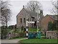
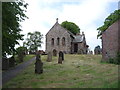
Anne T visited on 20th Aug 2017 - their rating: Cond: 3 Amb: 4 Access: 5 St. Mary's Beaumont: Church built on a motte, on a milecastle on a possible Saxon camp: We came to try to see St. Ann’s Well, marked on the OS map as being just off the small triangular village green, but found it was in a private garden surrounded by either a tall hedge or other buildings, so there was no access and no-one around to ask. According to the Old Cumbria Gazetteer, the well is at NY35055942, which is nearer the River Eden, says the well is at NY35055942 (which is different to the OS map) and: “This provided very cold water, useful for helping set the butter. By the time you’d got back up the bank your bucket was only half full.” Dated to 1867 to 1868.
There were lots of walkers trundling along Hadrian’s Wall Path at this point, with a large notice by the interpretation board saying there was a detour due to a large landslip. By this time, my attention had been grabbed by the interpretation board saying this church was built on the line of Hadrian’s Wall and that at one point, a turret (70A) would have stood on the site of the church. The church guide continues: “When the Normans arrived they constructed a motte and baillie as a vantage point to repel invasion from the Scots …. Stones from the wall provided ready building material.”
This is a very pleasant spot. There were so many tractors driving around at this time of the evening we felt out of place! There are farms all along the road through the village. I’d have liked to have seen across to the River Eden, but the farm buildings and houses along its western bank obscured the view. We decided on one final visit, to try and see St. Edward’s Monument (so wet we couldn’t get near last time).
 (PID:169558)")
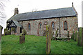
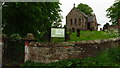
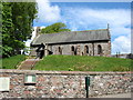
We came to this village to find St. Anne's (or St Ann's Well) which is marked on the OS map, but found it was on private land. Drawn to the interpretation board on the small village green near the church, we were astonished to find this little church was built on top of the site of Roman turret 70A, which in Norman times became a motte, then was replaced in the 12th century by a church. Not surprisingly, the church sits almost on the line of Hadrian's Wall and the modern Hadrian's Wall Path runs just in front of the church.
Walking up to the metal gates into the churchyard at the east end of the church, the form of the motte became clear and we walked all around the church. The motte has been 'nibbled into' at its southern side by the modern road through the village and is much less steep on the northern side, again because more recent farm buildings have been cut into the slope.
More information can be found on Pastscape Monument No. 10752 which adds that the church was restored in the 18th and 19th centuries and still contains stones from Hadrian's Wall (or the turret). They add that the site may originally have been a Saxon or Danish camp.
This site is scheduled - see Historic England List ID 1013510 which tells us this site is strategically placed on a local high point overlooking the River Eden, and that the remains of turret 70a still exist below the motte.
You may be viewing yesterday's version of this page. To see the most up to date information please register for a free account.
 (PID:169557)")
 (PID:169556)")
Do not use the above information on other web sites or publications without permission of the contributor.
Nearby Images from Geograph Britain and Ireland:
©2012(licence)
©2017(licence)
©2023(licence)
©2013(licence)
©2016(licence)
The above images may not be of the site on this page, they are loaded from Geograph.
Please Submit an Image of this site or go out and take one for us!
Click here to see more info for this site
Nearby sites
Key: Red: member's photo, Blue: 3rd party photo, Yellow: other image, Green: no photo - please go there and take one, Grey: site destroyed
Download sites to:
KML (Google Earth)
GPX (GPS waypoints)
CSV (Garmin/Navman)
CSV (Excel)
To unlock full downloads you need to sign up as a Contributory Member. Otherwise downloads are limited to 50 sites.
Turn off the page maps and other distractions
Nearby sites listing. In the following links * = Image available
979m SE 143° St Andrew's Well (Kirkandrews-on-Eden)* Holy Well or Sacred Spring (NY35395851)
2.6km NNE 24° Rockcliffe (Cumbria)* Ancient Cross (NY35896162)
2.8km NW 305° King Edward's Monument* Cairn (NY3257460920)
3.5km SE 127° Stainton West Ancient Mine, Quarry or other Industry (NY3759457137)
5.5km ESE 118° Roman Bridge Remains (Bitts Park)* Ancient Trackway (NY3961056670)
5.5km ESE 116° Hyssop Holme Well (Carlisle)* Holy Well or Sacred Spring (NY3974856801)
5.9km ESE 122° Tullie House Museum* Museum (NY3978556106)
6.0km ESE 111° Homeacres Holy Well (Stanwix)* Holy Well or Sacred Spring (NY40415709)
6.1km ESE 123° Carlisle Anglo Saxon Crosses* Ancient Cross (NY39885595)
6.2km ESE 122° Carlisle Cross* Ancient Cross (NY4008455931)
7.5km WSW 249° Finglandrigg Spa Well (Chalybeate)* Holy Well or Sacred Spring (NY2770956749)
7.6km NNW 331° Lochmaben Stane* Standing Stone (Menhir) (NY3123665983)
8.9km NNE 20° Arthuret Church cross* Ancient Cross (NY37936766)
9.0km NNE 19° St Michael's Holy Well* Holy Well or Sacred Spring (NY3789967755)
9.2km NNW 341° Gretna Sculptured Stone (NY319680)
9.3km SW 230° Fairy Well (Aikton)* Holy Well or Sacred Spring (NY27635340)
9.5km SSE 166° Chapel Flat Stone Circle (NY370500)
9.8km SSE 147° Tarn plantation* Stone Circle (NY4051)
10.4km SE 134° St Ninian's Well (Brisco)* Holy Well or Sacred Spring (NY42265201)
12.0km NW 324° Mossknowe 3* Cairn (NY2793169102)
12.0km NW 325° Mossknowe 2* Cairn (NY2806469266)
12.0km S 183° St Michael's Well (Shawk)* Holy Well or Sacred Spring (NY3395047280)
12.2km S 184° Shawk Quarries Holy Well (Dalston) Holy Well or Sacred Spring (NY3380047100)
12.3km NW 325° Mossknowe Tumulus* Cairn (NY27836948)
12.7km ESE 109° St Cuthbert's Holy Well* Holy Well or Sacred Spring (NY46735496)
View more nearby sites and additional images


 We would like to know more about this location. Please feel free to add a brief description and any relevant information in your own language.
 Wir möchten mehr über diese Stätte erfahren. Bitte zögern Sie nicht, eine kurze Beschreibung und relevante Informationen in Deutsch hinzuzufügen.
 Nous aimerions en savoir encore un peu sur les lieux. S'il vous plaît n'hesitez pas à ajouter une courte description et tous les renseignements pertinents dans votre propre langue.
 Quisieramos informarnos un poco más de las lugares. No dude en añadir una breve descripción y otros datos relevantes en su propio idioma.