<< Our Photo Pages >> St Candida's Well - Holy Well or Sacred Spring in England in Dorset
Submitted by vicky on Monday, 29 March 2004 Page Views: 9907
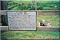
Springs and Holy WellsSite Name: St Candida's Well Alternative Name: The Saints Well, Whitchurch CanonicorumCountry: England
NOTE: This site is 1.267 km away from the location you searched for.
County: Dorset Type: Holy Well or Sacred Spring
Nearest Village: Morcombelake
Map Ref: SY3995193753 Landranger Map Number: 193
Latitude: 50.740267N Longitude: 2.852373W
Condition:
| 5 | Perfect |
| 4 | Almost Perfect |
| 3 | Reasonable but with some damage |
| 2 | Ruined but still recognisable as an ancient site |
| 1 | Pretty much destroyed, possibly visible as crop marks |
| 0 | No data. |
| -1 | Completely destroyed |
| 5 | Superb |
| 4 | Good |
| 3 | Ordinary |
| 2 | Not Good |
| 1 | Awful |
| 0 | No data. |
| 5 | Can be driven to, probably with disabled access |
| 4 | Short walk on a footpath |
| 3 | Requiring a bit more of a walk |
| 2 | A long walk |
| 1 | In the middle of nowhere, a nightmare to find |
| 0 | No data. |
| 5 | co-ordinates taken by GPS or official recorded co-ordinates |
| 4 | co-ordinates scaled from a detailed map |
| 3 | co-ordinates scaled from a bad map |
| 2 | co-ordinates of the nearest village |
| 1 | co-ordinates of the nearest town |
| 0 | no data |
Internal Links:
External Links:
")
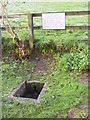
This well is recorded as Pastscape Monument No. 449775, which tells us the well consists of "a flow of water exuding from the hillside through a modern pipe into a hollow in the ground presumably caused by cattle .... ccording to local tradition the water has special healing powers for the eyes".
The Journal of Antiquities also features a page for this well as part of their entry for St Candida’s Church, Whitchurch Canonicorum, Dorset; scroll down their page for a description, local tradition and a list of reference sources for more information.
You may be viewing yesterday's version of this page. To see the most up to date information please register for a free account.
")
")
")
")
Do not use the above information on other web sites or publications without permission of the contributor.
Nearby Images from Geograph Britain and Ireland:
©2008(licence)
©2007(licence)
©2015(licence)
©2009(licence)
©2015(licence)
The above images may not be of the site on this page, they are loaded from Geograph.
Please Submit an Image of this site or go out and take one for us!
Click here to see more info for this site
Nearby sites
Key: Red: member's photo, Blue: 3rd party photo, Yellow: other image, Green: no photo - please go there and take one, Grey: site destroyed
Download sites to:
KML (Google Earth)
GPX (GPS waypoints)
CSV (Garmin/Navman)
CSV (Excel)
To unlock full downloads you need to sign up as a Contributory Member. Otherwise downloads are limited to 50 sites.
Turn off the page maps and other distractions
Nearby sites listing. In the following links * = Image available
1.7km N 350° St Candida & Holy Cross (Whitchurch Canonicorum)* Early Christian Sculptured Stone (SY3967895432)
1.8km SSE 159° Golden Cap Barrows* Barrow Cemetery (SY40569211)
3.8km SE 126° Doghouse Hill* Ancient Village or Settlement (SY430915)
4.6km NW 323° Coney's Castle* Hillfort (SY372975)
6.0km NNW 332° Lambert's Castle* Hillfort (SY372991)
6.0km WSW 255° Leper's Well (Lyme Regis)* Holy Well or Sacred Spring (SY3411292224)
6.8km N 3° Bettiscombe Stone Natural Stone / Erratic / Other Natural Feature (ST4036800561)
7.7km N 9° Pilsdon Pen* Hillfort (ST413013)
8.3km NNE 26° Lewesdon Hillfort Hillfort (ST437012)
9.6km NNE 20° St Dunstan's Well* Holy Well or Sacred Spring (ST433028)
9.7km W 265° Shapwick Hill Bowl Barrows Barrow Cemetery (SY303930)
10.6km ESE 117° Bind Barrow* Round Barrow(s) (SY494888)
10.8km E 98° Shipton Hill* Hillfort (SY507921)
11.4km WNW 294° Axminster Castle* Hillfort (SY296986)
11.7km W 271° Musbury Castle* Hillfort (SY282941)
13.0km E 99° Chilcombe Hill Barrows* Round Barrow(s) (SY528916)
13.1km E 97° Chilcombe Hill* Hillfort (SY530920)
13.5km NNE 31° Pickett Farm Neolithic Site Misc. Earthwork (ST47100519)
13.8km W 260° Hawksdown Camp Hillfort (SY26299143)
14.2km E 85° Eggardon Hill* Hillfort (SY54129472)
14.6km ESE 113° Puncknowle Bowl Barrows Round Barrow(s) (SY53308783)
14.7km E 86° Eggardon earthwork* Henge (SY54689460)
14.8km NW 307° Membury Castle Hillfort (ST282028)
15.2km NE 50° Hore Stones* Standing Stones (ST5178603403)
15.3km NE 44° Higher Ground Meadow Modern Burial Mound* Artificial Mound (ST5066904650)
View more nearby sites and additional images


 We would like to know more about this location. Please feel free to add a brief description and any relevant information in your own language.
 Wir möchten mehr über diese Stätte erfahren. Bitte zögern Sie nicht, eine kurze Beschreibung und relevante Informationen in Deutsch hinzuzufügen.
 Nous aimerions en savoir encore un peu sur les lieux. S'il vous plaît n'hesitez pas à ajouter une courte description et tous les renseignements pertinents dans votre propre langue.
 Quisieramos informarnos un poco más de las lugares. No dude en añadir una breve descripción y otros datos relevantes en su propio idioma.